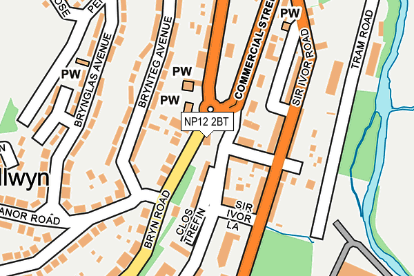
NP12 2BT lies on Station Houses in Pontllanfraith, Blackwood. NP12 2BT is located in the Pontllanfraith electoral ward, within the unitary authority of Caerphilly and the Welsh Parliamentary constituency of Islwyn. The Local Health Board is Aneurin Bevan University and the police force is Gwent. This postcode has been in use since June 1999.


GetTheData
Source: OS OpenMap – Local (Ordnance Survey)
Source: OS VectorMap District (Ordnance Survey)
Licence: Open Government Licence (requires attribution)
| Easting | 317758 |
| Northing | 195547 |
| Latitude | 51.652677 |
| Longitude | -3.190192 |
GetTheData
Source: Open Postcode Geo
Licence: Open Government Licence
| Street | Station Houses |
| Locality | Pontllanfraith |
| Town/City | Blackwood |
| Country | Wales |
| Postcode District | NP12 |
➜ See where NP12 is on a map ➜ Where is Pontllanfraith? | |
GetTheData
Source: Land Registry Price Paid Data
Licence: Open Government Licence
Elevation or altitude of NP12 2BT as distance above sea level:
| Metres | Feet | |
|---|---|---|
| Elevation | 150m | 492ft |
Elevation is measured from the approximate centre of the postcode, to the nearest point on an OS contour line from OS Terrain 50, which has contour spacing of ten vertical metres.
➜ How high above sea level am I? Find the elevation of your current position using your device's GPS.
GetTheData
Source: Open Postcode Elevation
Licence: Open Government Licence
| Ward | Pontllanfraith |
| Constituency | Islwyn |
GetTheData
Source: ONS Postcode Database
Licence: Open Government Licence
| Bird In Hand (Bryn Road) | Pontllanfraith | 40m |
| Bird In Hand (Bryn Road) | Pontllanfraith | 41m |
| Tredegar Junction (Blackwood Road) | Pontllanfraith | 77m |
| King David Tyres (Sir Ivor's Road) | Pontllanfraith | 111m |
| Tredegar Junction (Blackwood Road) | Pontllanfraith | 113m |
| Hengoed Station | 2.4km |
| Pengam Station | 3.4km |
| Newbridge Station | 3.6km |
GetTheData
Source: NaPTAN
Licence: Open Government Licence
| Percentage of properties with Next Generation Access | 100.0% |
| Percentage of properties with Superfast Broadband | 100.0% |
| Percentage of properties with Ultrafast Broadband | 0.0% |
| Percentage of properties with Full Fibre Broadband | 0.0% |
Superfast Broadband is between 30Mbps and 300Mbps
Ultrafast Broadband is > 300Mbps
| Percentage of properties unable to receive 2Mbps | 0.0% |
| Percentage of properties unable to receive 5Mbps | 0.0% |
| Percentage of properties unable to receive 10Mbps | 0.0% |
| Percentage of properties unable to receive 30Mbps | 0.0% |
GetTheData
Source: Ofcom
Licence: Ofcom Terms of Use (requires attribution)
GetTheData
Source: ONS Postcode Database
Licence: Open Government Licence


➜ Get more ratings from the Food Standards Agency
GetTheData
Source: Food Standards Agency
Licence: FSA terms & conditions
| Last Collection | |||
|---|---|---|---|
| Location | Mon-Fri | Sat | Distance |
| Bryn Road | 16:15 | 11:15 | 957m |
| Blackwood Post Office | 18:00 | 12:30 | 1,482m |
| Pentwynmawr | 16:00 | 11:30 | 1,983m |
GetTheData
Source: Dracos
Licence: Creative Commons Attribution-ShareAlike
The below table lists the International Territorial Level (ITL) codes (formerly Nomenclature of Territorial Units for Statistics (NUTS) codes) and Local Administrative Units (LAU) codes for NP12 2BT:
| ITL 1 Code | Name |
|---|---|
| TLL | Wales |
| ITL 2 Code | Name |
| TLL1 | West Wales and The Valleys |
| ITL 3 Code | Name |
| TLL16 | Gwent Valleys |
| LAU 1 Code | Name |
| W06000018 | Caerphilly |
GetTheData
Source: ONS Postcode Directory
Licence: Open Government Licence
The below table lists the Census Output Area (OA), Lower Layer Super Output Area (LSOA), and Middle Layer Super Output Area (MSOA) for NP12 2BT:
| Code | Name | |
|---|---|---|
| OA | W00007348 | |
| LSOA | W01001403 | Caerphilly 011C |
| MSOA | W02000300 | Caerphilly 011 |
GetTheData
Source: ONS Postcode Directory
Licence: Open Government Licence
| NP12 2JX | Penllwyn Avenue | 68m |
| NP12 2BU | Bryn Road | 75m |
| NP12 2BS | Blackwood Road | 115m |
| NP12 2BX | Brynteg Avenue | 126m |
| NP12 2JH | Sir Ivors Road | 129m |
| NP12 2JL | Sir Ivors Road | 133m |
| NP12 2DB | Brynglas Avenue | 179m |
| NP12 2NN | Manor Road | 188m |
| NP12 2JU | Gelligroes Road | 191m |
| NP12 2DD | Brynglas Avenue | 200m |
GetTheData
Source: Open Postcode Geo; Land Registry Price Paid Data
Licence: Open Government Licence