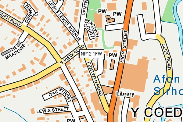
NP12 1FW is located in the Blackwood electoral ward, within the unitary authority of Caerphilly and the Welsh Parliamentary constituency of Islwyn. The Local Health Board is Aneurin Bevan University and the police force is Gwent. This postcode has been in use since March 2017.


GetTheData
Source: OS OpenMap – Local (Ordnance Survey)
Source: OS VectorMap District (Ordnance Survey)
Licence: Open Government Licence (requires attribution)
| Easting | 317386 |
| Northing | 197521 |
| Latitude | 51.670367 |
| Longitude | -3.196036 |
GetTheData
Source: Open Postcode Geo
Licence: Open Government Licence
| Country | Wales |
| Postcode District | NP12 |
➜ See where NP12 is on a map ➜ Where is Blackwood? | |
GetTheData
Source: Land Registry Price Paid Data
Licence: Open Government Licence
| Ward | Blackwood |
| Constituency | Islwyn |
GetTheData
Source: ONS Postcode Database
Licence: Open Government Licence
| Asda (High Street) | Blackwood | 74m |
| Aldi (High Street) | Blackwood | 88m |
| Pentwyn Road Garage (Pentwyn Road) | Blackwood | 99m |
| Pentwyn Road Garage (Pentwyn Road) | Blackwood | 102m |
| Cenotaph (Lewis Avenue) | Blackwood | 142m |
| Pengam Station | 2.4km |
| Gilfach Fargoed Station | 2.6km |
| Hengoed Station | 3.2km |
GetTheData
Source: NaPTAN
Licence: Open Government Licence
| Percentage of properties with Next Generation Access | 100.0% |
| Percentage of properties with Superfast Broadband | 100.0% |
| Percentage of properties with Ultrafast Broadband | 0.0% |
| Percentage of properties with Full Fibre Broadband | 0.0% |
Superfast Broadband is between 30Mbps and 300Mbps
Ultrafast Broadband is > 300Mbps
| Median download speed | 19.9Mbps |
| Average download speed | 35.4Mbps |
| Maximum download speed | 80.00Mbps |
| Median upload speed | 1.2Mbps |
| Average upload speed | 7.1Mbps |
| Maximum upload speed | 20.00Mbps |
| Percentage of properties unable to receive 2Mbps | 0.0% |
| Percentage of properties unable to receive 5Mbps | 0.0% |
| Percentage of properties unable to receive 10Mbps | 0.0% |
| Percentage of properties unable to receive 30Mbps | 0.0% |
GetTheData
Source: Ofcom
Licence: Ofcom Terms of Use (requires attribution)
GetTheData
Source: ONS Postcode Database
Licence: Open Government Licence


➜ Get more ratings from the Food Standards Agency
GetTheData
Source: Food Standards Agency
Licence: FSA terms & conditions
| Last Collection | |||
|---|---|---|---|
| Location | Mon-Fri | Sat | Distance |
| Bloomfield Road Post Office | 16:00 | 11:45 | 266m |
| Blackwood Post Office | 18:00 | 12:30 | 528m |
| Cefn Fforest Post Office | 17:00 | 12:00 | 1,203m |
GetTheData
Source: Dracos
Licence: Creative Commons Attribution-ShareAlike
The below table lists the International Territorial Level (ITL) codes (formerly Nomenclature of Territorial Units for Statistics (NUTS) codes) and Local Administrative Units (LAU) codes for NP12 1FW:
| ITL 1 Code | Name |
|---|---|
| TLL | Wales |
| ITL 2 Code | Name |
| TLL1 | West Wales and The Valleys |
| ITL 3 Code | Name |
| TLL16 | Gwent Valleys |
| LAU 1 Code | Name |
| W06000018 | Caerphilly |
GetTheData
Source: ONS Postcode Directory
Licence: Open Government Licence
The below table lists the Census Output Area (OA), Lower Layer Super Output Area (LSOA), and Middle Layer Super Output Area (MSOA) for NP12 1FW:
| Code | Name | |
|---|---|---|
| OA | W00007079 | |
| LSOA | W01001347 | Caerphilly 005C |
| MSOA | W02000294 | Caerphilly 005 |
GetTheData
Source: ONS Postcode Directory
Licence: Open Government Licence
| NP12 1HN | Pentwyn Road | 78m |
| NP12 1AY | High Street | 82m |
| NP12 1HL | Pentwyn Court | 98m |
| NP12 1QA | Cefn Road | 121m |
| NP12 1HR | South View Road | 132m |
| NP12 1BA | High Street | 154m |
| NP12 1PZ | Mount Pleasant | 164m |
| NP12 1HW | Pentwyn Road | 179m |
| NP12 1BE | High Street | 185m |
| NP12 1PU | Holly Place | 186m |
GetTheData
Source: Open Postcode Geo; Land Registry Price Paid Data
Licence: Open Government Licence