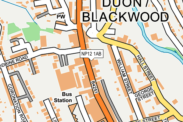
NP12 1AB lies on High Street in Blackwood. NP12 1AB is located in the Blackwood electoral ward, within the unitary authority of Caerphilly and the Welsh Parliamentary constituency of Islwyn. The Local Health Board is Aneurin Bevan University and the police force is Gwent. This postcode has been in use since June 1999.


GetTheData
Source: OS OpenMap – Local (Ordnance Survey)
Source: OS VectorMap District (Ordnance Survey)
Licence: Open Government Licence (requires attribution)
| Easting | 317442 |
| Northing | 197111 |
| Latitude | 51.666687 |
| Longitude | -3.195121 |
GetTheData
Source: Open Postcode Geo
Licence: Open Government Licence
| Street | High Street |
| Town/City | Blackwood |
| Country | Wales |
| Postcode District | NP12 |
➜ See where NP12 is on a map ➜ Where is Blackwood? | |
GetTheData
Source: Land Registry Price Paid Data
Licence: Open Government Licence
Elevation or altitude of NP12 1AB as distance above sea level:
| Metres | Feet | |
|---|---|---|
| Elevation | 160m | 525ft |
Elevation is measured from the approximate centre of the postcode, to the nearest point on an OS contour line from OS Terrain 50, which has contour spacing of ten vertical metres.
➜ How high above sea level am I? Find the elevation of your current position using your device's GPS.
GetTheData
Source: Open Postcode Elevation
Licence: Open Government Licence
| Ward | Blackwood |
| Constituency | Islwyn |
GetTheData
Source: ONS Postcode Database
Licence: Open Government Licence
| Pentwyn Road Garage (Pentwyn Road) | Blackwood | 320m |
| Pentwyn Road Garage (Pentwyn Road) | Blackwood | 321m |
| Asda (High Street) | Blackwood | 353m |
| Asda Car Park (Grounds) | Blackwood | 353m |
| Woodbine Road (Albany Road) | Blackwood | 362m |
| Pengam Station | 2.5km |
| Gilfach Fargoed Station | 2.9km |
| Hengoed Station | 2.9km |
GetTheData
Source: NaPTAN
Licence: Open Government Licence
| Median download speed | 20.5Mbps |
| Average download speed | 26.7Mbps |
| Maximum download speed | 73.75Mbps |
| Median upload speed | 1.2Mbps |
| Average upload speed | 4.2Mbps |
| Maximum upload speed | 20.00Mbps |
GetTheData
Source: Ofcom
Licence: Ofcom Terms of Use (requires attribution)
GetTheData
Source: ONS Postcode Database
Licence: Open Government Licence


➜ Get more ratings from the Food Standards Agency
GetTheData
Source: Food Standards Agency
Licence: FSA terms & conditions
| Last Collection | |||
|---|---|---|---|
| Location | Mon-Fri | Sat | Distance |
| Blackwood Post Office | 18:00 | 12:30 | 115m |
| Bloomfield Road Post Office | 16:00 | 11:45 | 476m |
| Cefn Fforest Post Office | 17:00 | 12:00 | 1,413m |
GetTheData
Source: Dracos
Licence: Creative Commons Attribution-ShareAlike
The below table lists the International Territorial Level (ITL) codes (formerly Nomenclature of Territorial Units for Statistics (NUTS) codes) and Local Administrative Units (LAU) codes for NP12 1AB:
| ITL 1 Code | Name |
|---|---|
| TLL | Wales |
| ITL 2 Code | Name |
| TLL1 | West Wales and The Valleys |
| ITL 3 Code | Name |
| TLL16 | Gwent Valleys |
| LAU 1 Code | Name |
| W06000018 | Caerphilly |
GetTheData
Source: ONS Postcode Directory
Licence: Open Government Licence
The below table lists the Census Output Area (OA), Lower Layer Super Output Area (LSOA), and Middle Layer Super Output Area (MSOA) for NP12 1AB:
| Code | Name | |
|---|---|---|
| OA | W00007058 | |
| LSOA | W01001350 | Caerphilly 009C |
| MSOA | W02000298 | Caerphilly 009 |
GetTheData
Source: ONS Postcode Directory
Licence: Open Government Licence
| NP12 1AF | High Street | 39m |
| NP12 1NU | William Street | 73m |
| NP12 1NR | Hall Street | 78m |
| NP12 1AD | High Street | 79m |
| NP12 1AE | High Street | 88m |
| NP12 1QL | Highland Terrace | 118m |
| NP12 1QN | Highland Terrace | 121m |
| NP12 1NW | William Street | 137m |
| NP12 1PN | High Street | 151m |
| NP12 1QJ | Woodbine Road | 152m |
GetTheData
Source: Open Postcode Geo; Land Registry Price Paid Data
Licence: Open Government Licence