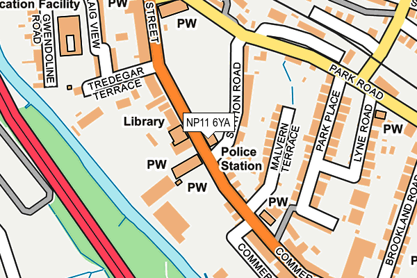
NP11 6YA is located in the Risca West electoral ward, within the unitary authority of Caerphilly and the Welsh Parliamentary constituency of Islwyn. The Local Health Board is Aneurin Bevan University and the police force is Gwent. This postcode has been in use since June 1999.


GetTheData
Source: OS OpenMap – Local (Ordnance Survey)
Source: OS VectorMap District (Ordnance Survey)
Licence: Open Government Licence (requires attribution)
| Easting | 323950 |
| Northing | 190304 |
| Latitude | 51.606415 |
| Longitude | -3.099559 |
GetTheData
Source: Open Postcode Geo
Licence: Open Government Licence
| Country | Wales |
| Postcode District | NP11 |
➜ See where NP11 is on a map ➜ Where is Risca? | |
GetTheData
Source: Land Registry Price Paid Data
Licence: Open Government Licence
Elevation or altitude of NP11 6YA as distance above sea level:
| Metres | Feet | |
|---|---|---|
| Elevation | 50m | 164ft |
Elevation is measured from the approximate centre of the postcode, to the nearest point on an OS contour line from OS Terrain 50, which has contour spacing of ten vertical metres.
➜ How high above sea level am I? Find the elevation of your current position using your device's GPS.
GetTheData
Source: Open Postcode Elevation
Licence: Open Government Licence
| Ward | Risca West |
| Constituency | Islwyn |
GetTheData
Source: ONS Postcode Database
Licence: Open Government Licence
| St Margaret's Church (Commercial Street) | Pontymister | 155m |
| St Margaret's Church (Commercial Street) | Pontymister | 167m |
| Moriah Baptist Church (Tredegar Street) | Risca | 176m |
| Spar (Tredegar Street) | Risca | 199m |
| Park Road | Risca | 213m |
| Risca & Pontymister Station | 0.5km |
| Crosskeys Station | 2.4km |
| Rogerstone Station | 2.6km |
GetTheData
Source: NaPTAN
Licence: Open Government Licence
GetTheData
Source: ONS Postcode Database
Licence: Open Government Licence


➜ Get more ratings from the Food Standards Agency
GetTheData
Source: Food Standards Agency
Licence: FSA terms & conditions
| Last Collection | |||
|---|---|---|---|
| Location | Mon-Fri | Sat | Distance |
| Rogerstone Post Office | 17:30 | 12:00 | 3,198m |
| Tydu Rogerstone | 16:00 | 11:15 | 3,522m |
| Tregwilym Road | 16:00 | 11:15 | 3,900m |
GetTheData
Source: Dracos
Licence: Creative Commons Attribution-ShareAlike
The below table lists the International Territorial Level (ITL) codes (formerly Nomenclature of Territorial Units for Statistics (NUTS) codes) and Local Administrative Units (LAU) codes for NP11 6YA:
| ITL 1 Code | Name |
|---|---|
| TLL | Wales |
| ITL 2 Code | Name |
| TLL1 | West Wales and The Valleys |
| ITL 3 Code | Name |
| TLL16 | Gwent Valleys |
| LAU 1 Code | Name |
| W06000018 | Caerphilly |
GetTheData
Source: ONS Postcode Directory
Licence: Open Government Licence
The below table lists the Census Output Area (OA), Lower Layer Super Output Area (LSOA), and Middle Layer Super Output Area (MSOA) for NP11 6YA:
| Code | Name | |
|---|---|---|
| OA | W00007385 | |
| LSOA | W01001412 | Caerphilly 017B |
| MSOA | W02000306 | Caerphilly 017 |
GetTheData
Source: ONS Postcode Directory
Licence: Open Government Licence
| NP11 6BX | Station Road | 62m |
| NP11 6AU | Malvern Terrace | 89m |
| NP11 6BW | Tredegar Street | 110m |
| NP11 6BT | Tredegar Terrace | 128m |
| NP11 6AS | Park Place | 149m |
| NP11 6BY | Tredegar Terrace | 166m |
| NP11 6BN | Park Place | 171m |
| NP11 6BZ | Wesley Place | 191m |
| NP11 6PW | Park Road | 202m |
| NP11 6AY | Commercial Street | 206m |
GetTheData
Source: Open Postcode Geo; Land Registry Price Paid Data
Licence: Open Government Licence