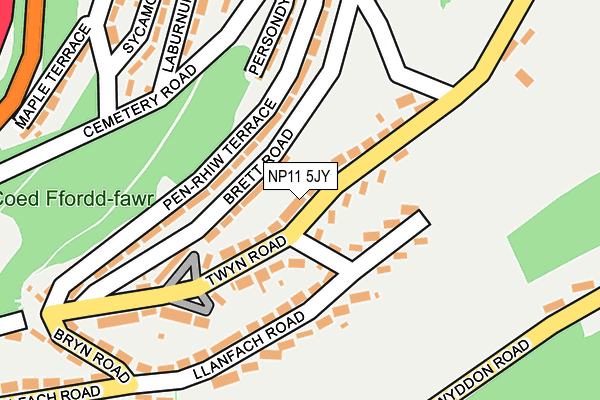
NP11 5JY lies on Twyn Road in Abercarn, Newport. NP11 5JY is located in the Abercarn electoral ward, within the unitary authority of Caerphilly and the Welsh Parliamentary constituency of Islwyn. The Local Health Board is Aneurin Bevan University and the police force is Gwent. This postcode has been in use since June 1999.


GetTheData
Source: OS OpenMap – Local (Ordnance Survey)
Source: OS VectorMap District (Ordnance Survey)
Licence: Open Government Licence (requires attribution)
| Easting | 322121 |
| Northing | 195303 |
| Latitude | 51.651103 |
| Longitude | -3.127077 |
GetTheData
Source: Open Postcode Geo
Licence: Open Government Licence
| Street | Twyn Road |
| Locality | Abercarn |
| Town/City | Newport |
| Country | Wales |
| Postcode District | NP11 |
➜ See where NP11 is on a map ➜ Where is Abercarn? | |
GetTheData
Source: Land Registry Price Paid Data
Licence: Open Government Licence
Elevation or altitude of NP11 5JY as distance above sea level:
| Metres | Feet | |
|---|---|---|
| Elevation | 200m | 656ft |
Elevation is measured from the approximate centre of the postcode, to the nearest point on an OS contour line from OS Terrain 50, which has contour spacing of ten vertical metres.
➜ How high above sea level am I? Find the elevation of your current position using your device's GPS.
GetTheData
Source: Open Postcode Elevation
Licence: Open Government Licence
| Ward | Abercarn |
| Constituency | Islwyn |
GetTheData
Source: ONS Postcode Database
Licence: Open Government Licence
2020 9 OCT £232,000 |
2019 25 OCT £229,000 |
2012 8 JUN £115,000 |
GetTheData
Source: HM Land Registry Price Paid Data
Licence: Contains HM Land Registry data © Crown copyright and database right 2025. This data is licensed under the Open Government Licence v3.0.
| Clytha Square (Llanfach Road) | Llanfach | 54m |
| Penrhiw Terrace | Abercarn | 103m |
| Twyn Place (Twyn Road) | Llanfach | 157m |
| Persondy Terrace (Cemetery Road) | Persondy | 246m |
| Maple Terrace (Acacia Terrace) | Persondy | 277m |
| Newbridge Station | 2km |
| Crosskeys Station | 3.4km |
GetTheData
Source: NaPTAN
Licence: Open Government Licence
| Percentage of properties with Next Generation Access | 100.0% |
| Percentage of properties with Superfast Broadband | 5.7% |
| Percentage of properties with Ultrafast Broadband | 0.0% |
| Percentage of properties with Full Fibre Broadband | 0.0% |
Superfast Broadband is between 30Mbps and 300Mbps
Ultrafast Broadband is > 300Mbps
| Median download speed | 13.3Mbps |
| Average download speed | 12.5Mbps |
| Maximum download speed | 33.16Mbps |
| Median upload speed | 1.0Mbps |
| Average upload speed | 1.5Mbps |
| Maximum upload speed | 5.52Mbps |
| Percentage of properties unable to receive 2Mbps | 0.0% |
| Percentage of properties unable to receive 5Mbps | 0.0% |
| Percentage of properties unable to receive 10Mbps | 0.0% |
| Percentage of properties unable to receive 30Mbps | 94.3% |
GetTheData
Source: Ofcom
Licence: Ofcom Terms of Use (requires attribution)
Estimated total energy consumption in NP11 5JY by fuel type, 2015.
| Consumption (kWh) | 480,478 |
|---|---|
| Meter count | 35 |
| Mean (kWh/meter) | 13,728 |
| Median (kWh/meter) | 16,190 |
| Consumption (kWh) | 113,727 |
|---|---|
| Meter count | 34 |
| Mean (kWh/meter) | 3,345 |
| Median (kWh/meter) | 2,730 |
GetTheData
Source: Postcode level gas estimates: 2015 (experimental)
Source: Postcode level electricity estimates: 2015 (experimental)
Licence: Open Government Licence
GetTheData
Source: ONS Postcode Database
Licence: Open Government Licence


➜ Get more ratings from the Food Standards Agency
GetTheData
Source: Food Standards Agency
Licence: FSA terms & conditions
| Last Collection | |||
|---|---|---|---|
| Location | Mon-Fri | Sat | Distance |
| Newbridge Post Office | 17:00 | 11:45 | 1,917m |
| Pentwynmawr | 16:00 | 11:30 | 2,657m |
| Blackwood Post Office | 18:00 | 12:30 | 4,973m |
GetTheData
Source: Dracos
Licence: Creative Commons Attribution-ShareAlike
The below table lists the International Territorial Level (ITL) codes (formerly Nomenclature of Territorial Units for Statistics (NUTS) codes) and Local Administrative Units (LAU) codes for NP11 5JY:
| ITL 1 Code | Name |
|---|---|
| TLL | Wales |
| ITL 2 Code | Name |
| TLL1 | West Wales and The Valleys |
| ITL 3 Code | Name |
| TLL16 | Gwent Valleys |
| LAU 1 Code | Name |
| W06000018 | Caerphilly |
GetTheData
Source: ONS Postcode Directory
Licence: Open Government Licence
The below table lists the Census Output Area (OA), Lower Layer Super Output Area (LSOA), and Middle Layer Super Output Area (MSOA) for NP11 5JY:
| Code | Name | |
|---|---|---|
| OA | W00006968 | |
| LSOA | W01001328 | Caerphilly 014B |
| MSOA | W02000303 | Caerphilly 014 |
GetTheData
Source: ONS Postcode Directory
Licence: Open Government Licence
| NP11 5JW | Brett Road | 54m |
| NP11 5JZ | Clytha Square | 82m |
| NP11 5JU | Penrhiw Terrace | 120m |
| NP11 5LA | Llanfach Road | 139m |
| NP11 5AS | Twyn Road | 150m |
| NP11 5BT | Cemetery Lane | 151m |
| NP11 5JX | Twyn Place | 158m |
| NP11 5JT | Penrhiw Terrace | 158m |
| NP11 5JS | Persondy Terrace | 180m |
| NP11 5JR | Ystrad Terrace | 224m |
GetTheData
Source: Open Postcode Geo; Land Registry Price Paid Data
Licence: Open Government Licence