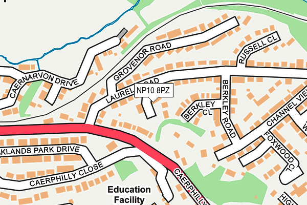
NP10 8PZ lies on Wentworth Close in Bassaleg, Newport. NP10 8PZ is located in the Graig electoral ward, within the unitary authority of Newport and the Welsh Parliamentary constituency of Newport West. The Local Health Board is Aneurin Bevan University and the police force is Gwent. This postcode has been in use since June 1999.


GetTheData
Source: OS OpenMap – Local (Ordnance Survey)
Source: OS VectorMap District (Ordnance Survey)
Licence: Open Government Licence (requires attribution)
| Easting | 326657 |
| Northing | 187289 |
| Latitude | 51.579671 |
| Longitude | -3.059846 |
GetTheData
Source: Open Postcode Geo
Licence: Open Government Licence
| Street | Wentworth Close |
| Locality | Bassaleg |
| Town/City | Newport |
| Country | Wales |
| Postcode District | NP10 |
➜ See where NP10 is on a map ➜ Where is Newport? | |
GetTheData
Source: Land Registry Price Paid Data
Licence: Open Government Licence
Elevation or altitude of NP10 8PZ as distance above sea level:
| Metres | Feet | |
|---|---|---|
| Elevation | 60m | 197ft |
Elevation is measured from the approximate centre of the postcode, to the nearest point on an OS contour line from OS Terrain 50, which has contour spacing of ten vertical metres.
➜ How high above sea level am I? Find the elevation of your current position using your device's GPS.
GetTheData
Source: Open Postcode Elevation
Licence: Open Government Licence
| Ward | Graig |
| Constituency | Newport West |
GetTheData
Source: ONS Postcode Database
Licence: Open Government Licence
3, WENTWORTH CLOSE, BASSALEG, NEWPORT, NP10 8PZ 2017 11 DEC £228,500 |
3, WENTWORTH CLOSE, BASSALEG, NEWPORT, NP10 8PZ 2017 11 DEC £228,500 |
GARTH COURTYARD, WENTWORTH CLOSE, BASSALEG, NEWPORT, NP10 8PZ 2006 30 NOV £312,500 |
GARTH FARM HOUSE, WENTWORTH CLOSE, BASSALEG, NEWPORT, NP10 8PZ 2005 15 APR £297,000 |
GARTH FARM HOUSE, WENTWORTH CLOSE, BASSALEG, NEWPORT, NP10 8PZ 1999 27 AUG £97,995 |
GetTheData
Source: HM Land Registry Price Paid Data
Licence: Contains HM Land Registry data © Crown copyright and database right 2025. This data is licensed under the Open Government Licence v3.0.
| Wentworth Close (Laurel Road) | Bassaleg | 46m |
| Wentworth Close (Laurel Road) | Bassaleg | 47m |
| Friendly Fox (Caerphilly Road) | Bassaleg | 85m |
| Friendly Fox (Caerphilly Road) | Bassaleg | 182m |
| Channel View (Laurel Road) | Bassaleg | 296m |
| Rogerstone Station | 1.8km |
| Risca & Pontymister Station | 3.7km |
| Newport (S Wales) Station | 4.2km |
GetTheData
Source: NaPTAN
Licence: Open Government Licence
| Percentage of properties with Next Generation Access | 100.0% |
| Percentage of properties with Superfast Broadband | 100.0% |
| Percentage of properties with Ultrafast Broadband | 0.0% |
| Percentage of properties with Full Fibre Broadband | 0.0% |
Superfast Broadband is between 30Mbps and 300Mbps
Ultrafast Broadband is > 300Mbps
| Percentage of properties unable to receive 2Mbps | 0.0% |
| Percentage of properties unable to receive 5Mbps | 0.0% |
| Percentage of properties unable to receive 10Mbps | 0.0% |
| Percentage of properties unable to receive 30Mbps | 0.0% |
GetTheData
Source: Ofcom
Licence: Ofcom Terms of Use (requires attribution)
Estimated total energy consumption in NP10 8PZ by fuel type, 2015.
| Consumption (kWh) | 24,571 |
|---|---|
| Meter count | 6 |
| Mean (kWh/meter) | 4,095 |
| Median (kWh/meter) | 3,820 |
GetTheData
Source: Postcode level gas estimates: 2015 (experimental)
Source: Postcode level electricity estimates: 2015 (experimental)
Licence: Open Government Licence
GetTheData
Source: ONS Postcode Database
Licence: Open Government Licence


➜ Get more ratings from the Food Standards Agency
GetTheData
Source: Food Standards Agency
Licence: FSA terms & conditions
| Last Collection | |||
|---|---|---|---|
| Location | Mon-Fri | Sat | Distance |
| Tregwilym Road | 16:00 | 11:15 | 752m |
| Tydu Rogerstone | 16:00 | 11:15 | 884m |
| Rogerstone Post Office | 17:30 | 12:00 | 1,355m |
GetTheData
Source: Dracos
Licence: Creative Commons Attribution-ShareAlike
The below table lists the International Territorial Level (ITL) codes (formerly Nomenclature of Territorial Units for Statistics (NUTS) codes) and Local Administrative Units (LAU) codes for NP10 8PZ:
| ITL 1 Code | Name |
|---|---|
| TLL | Wales |
| ITL 2 Code | Name |
| TLL2 | East Wales |
| ITL 3 Code | Name |
| TLL21 | Monmouthshire and Newport |
| LAU 1 Code | Name |
| W06000022 | Newport |
GetTheData
Source: ONS Postcode Directory
Licence: Open Government Licence
The below table lists the Census Output Area (OA), Lower Layer Super Output Area (LSOA), and Middle Layer Super Output Area (MSOA) for NP10 8PZ:
| Code | Name | |
|---|---|---|
| OA | W00008503 | |
| LSOA | W01001638 | Newport 016C |
| MSOA | W02000362 | Newport 016 |
GetTheData
Source: ONS Postcode Directory
Licence: Open Government Licence
| NP10 8RA | Orchard Close | 62m |
| NP10 8PT | Laurel Road | 66m |
| NP10 8XS | Laurel Road | 76m |
| NP10 8PS | Laurel Road | 76m |
| NP10 8PR | Berkley Close | 76m |
| NP10 8LW | Caerphilly Road | 117m |
| NP10 8QA | Laurel Road | 142m |
| NP10 8PP | Berkley Road | 155m |
| NP10 8PY | Grosvenor Road | 166m |
| NP10 8PJ | Channel View | 197m |
GetTheData
Source: Open Postcode Geo; Land Registry Price Paid Data
Licence: Open Government Licence