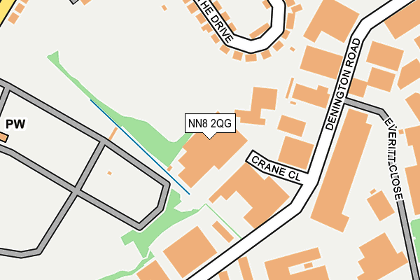
NN8 2QG is located in the Croyland and Swanspool electoral ward, within the unitary authority of North Northamptonshire and the English Parliamentary constituency of Wellingborough. The Sub Integrated Care Board (ICB) Location is NHS Northamptonshire ICB - 78H and the police force is Northamptonshire. This postcode has been in use since August 1992.


GetTheData
Source: OS OpenMap – Local (Ordnance Survey)
Source: OS VectorMap District (Ordnance Survey)
Licence: Open Government Licence (requires attribution)
| Easting | 489383 |
| Northing | 266937 |
| Latitude | 52.293303 |
| Longitude | -0.690849 |
GetTheData
Source: Open Postcode Geo
Licence: Open Government Licence
| Country | England |
| Postcode District | NN8 |
➜ See where NN8 is on a map ➜ Where is Wellingborough? | |
GetTheData
Source: Land Registry Price Paid Data
Licence: Open Government Licence
Elevation or altitude of NN8 2QG as distance above sea level:
| Metres | Feet | |
|---|---|---|
| Elevation | 50m | 164ft |
Elevation is measured from the approximate centre of the postcode, to the nearest point on an OS contour line from OS Terrain 50, which has contour spacing of ten vertical metres.
➜ How high above sea level am I? Find the elevation of your current position using your device's GPS.
GetTheData
Source: Open Postcode Elevation
Licence: Open Government Licence
| Ward | Croyland And Swanspool |
| Constituency | Wellingborough |
GetTheData
Source: ONS Postcode Database
Licence: Open Government Licence
| Crane Close (Denington Road) | Wellingborough | 155m |
| Crane Close (Denington Road) | Wellingborough | 159m |
| Dennington House (Denington Road) | Wellingborough | 171m |
| Dennington House (Denington Road) | Wellingborough | 188m |
| Mayfayre House (Denington Road) | Wellingborough | 247m |
| Wellingborough Station | 1.5km |
GetTheData
Source: NaPTAN
Licence: Open Government Licence
GetTheData
Source: ONS Postcode Database
Licence: Open Government Licence


➜ Get more ratings from the Food Standards Agency
GetTheData
Source: Food Standards Agency
Licence: FSA terms & conditions
| Last Collection | |||
|---|---|---|---|
| Location | Mon-Fri | Sat | Distance |
| Dennington Est | 18:30 | 147m | |
| Dennington Est | 18:30 | 11:00 | 148m |
| Tesco's Store Turnells Mill Ln | 16:15 | 11:00 | 565m |
GetTheData
Source: Dracos
Licence: Creative Commons Attribution-ShareAlike
The below table lists the International Territorial Level (ITL) codes (formerly Nomenclature of Territorial Units for Statistics (NUTS) codes) and Local Administrative Units (LAU) codes for NN8 2QG:
| ITL 1 Code | Name |
|---|---|
| TLF | East Midlands (England) |
| ITL 2 Code | Name |
| TLF2 | Leicestershire, Rutland and Northamptonshire |
| ITL 3 Code | Name |
| TLF25 | North Northamptonshire |
| LAU 1 Code | Name |
| E07000156 | Wellingborough |
GetTheData
Source: ONS Postcode Directory
Licence: Open Government Licence
The below table lists the Census Output Area (OA), Lower Layer Super Output Area (LSOA), and Middle Layer Super Output Area (MSOA) for NN8 2QG:
| Code | Name | |
|---|---|---|
| OA | E00138994 | |
| LSOA | E01027317 | Wellingborough 008A |
| MSOA | E02005699 | Wellingborough 008 |
GetTheData
Source: ONS Postcode Directory
Licence: Open Government Licence
| NN8 2QH | Denington Road | 128m |
| NN8 2DD | The Drive | 212m |
| NN8 2QR | Denington Court | 212m |
| NN8 2DF | The Drive | 225m |
| NN8 2DE | The Drive | 255m |
| NN8 2DB | The Drive | 269m |
| NN8 2JH | Doddington Road | 288m |
| NN8 2DA | Broadway | 352m |
| NN8 2LX | Campbell Road | 427m |
| NN8 2LJ | Doddington Road | 443m |
GetTheData
Source: Open Postcode Geo; Land Registry Price Paid Data
Licence: Open Government Licence