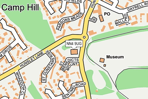
NN4 9UG is located in the Sixfields electoral ward, within the unitary authority of West Northamptonshire and the English Parliamentary constituency of South Northamptonshire. The Sub Integrated Care Board (ICB) Location is NHS Northamptonshire ICB - 78H and the police force is Northamptonshire. This postcode has been in use since July 1983.


GetTheData
Source: OS OpenMap – Local (Ordnance Survey)
Source: OS VectorMap District (Ordnance Survey)
Licence: Open Government Licence (requires attribution)
| Easting | 473333 |
| Northing | 258547 |
| Latitude | 52.220261 |
| Longitude | -0.927951 |
GetTheData
Source: Open Postcode Geo
Licence: Open Government Licence
| Country | England |
| Postcode District | NN4 |
➜ See where NN4 is on a map ➜ Where is Northampton? | |
GetTheData
Source: Land Registry Price Paid Data
Licence: Open Government Licence
Elevation or altitude of NN4 9UG as distance above sea level:
| Metres | Feet | |
|---|---|---|
| Elevation | 100m | 328ft |
Elevation is measured from the approximate centre of the postcode, to the nearest point on an OS contour line from OS Terrain 50, which has contour spacing of ten vertical metres.
➜ How high above sea level am I? Find the elevation of your current position using your device's GPS.
GetTheData
Source: Open Postcode Elevation
Licence: Open Government Licence
| Ward | Sixfields |
| Constituency | South Northamptonshire |
GetTheData
Source: ONS Postcode Database
Licence: Open Government Licence
| Museum & Railway (Hunsbury Hill Road) | Camp Hill | 26m |
| Hunsbury Hill Road (Hunslet Lane) | Camp Hill | 64m |
| Museum & Railway (Hunsbury Hill Road) | Camp Hill | 143m |
| Health Centre (Hunsbury Hill Road) | Camp Hill | 165m |
| Whaddon Close (Hunslet Lane) | Camp Hill | 197m |
| Northampton Station | 2.4km |
GetTheData
Source: NaPTAN
Licence: Open Government Licence
GetTheData
Source: ONS Postcode Database
Licence: Open Government Licence


➜ Get more ratings from the Food Standards Agency
GetTheData
Source: Food Standards Agency
Licence: FSA terms & conditions
| Last Collection | |||
|---|---|---|---|
| Location | Mon-Fri | Sat | Distance |
| Camphill Tso | 17:30 | 11:30 | 156m |
| Greenglades | 17:30 | 11:30 | 377m |
| Tansy Close | 17:30 | 11:30 | 653m |
GetTheData
Source: Dracos
Licence: Creative Commons Attribution-ShareAlike
The below table lists the International Territorial Level (ITL) codes (formerly Nomenclature of Territorial Units for Statistics (NUTS) codes) and Local Administrative Units (LAU) codes for NN4 9UG:
| ITL 1 Code | Name |
|---|---|
| TLF | East Midlands (England) |
| ITL 2 Code | Name |
| TLF2 | Leicestershire, Rutland and Northamptonshire |
| ITL 3 Code | Name |
| TLF24 | West Northamptonshire |
| LAU 1 Code | Name |
| E07000154 | Northampton |
GetTheData
Source: ONS Postcode Directory
Licence: Open Government Licence
The below table lists the Census Output Area (OA), Lower Layer Super Output Area (LSOA), and Middle Layer Super Output Area (MSOA) for NN4 9UG:
| Code | Name | |
|---|---|---|
| OA | E00138626 | |
| LSOA | E01027252 | Northampton 026D |
| MSOA | E02005675 | Northampton 026 |
GetTheData
Source: ONS Postcode Directory
Licence: Open Government Licence
| NN4 9XN | St Benedicts Mount | 80m |
| NN4 9XL | St Dunstans Rise | 120m |
| NN4 9UF | Sentinel Road | 169m |
| NN4 9YN | Summerfields | 206m |
| NN4 9UR | Mallard Close | 232m |
| NN4 9SZ | Gresham Drive | 264m |
| NN4 9RQ | Farraxton Square | 275m |
| NN4 9YJ | Cullahill Court | 280m |
| NN4 9YG | Miller Hill | 282m |
| NN4 9XS | Whaddon Close | 286m |
GetTheData
Source: Open Postcode Geo; Land Registry Price Paid Data
Licence: Open Government Licence