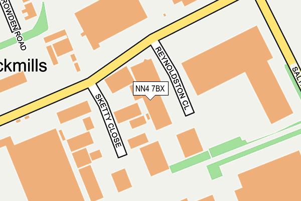
NN4 7BX is located in the Nene Valley electoral ward, within the unitary authority of West Northamptonshire and the English Parliamentary constituency of South Northamptonshire. The Sub Integrated Care Board (ICB) Location is NHS Northamptonshire ICB - 78H and the police force is Northamptonshire. This postcode has been in use since June 1997.


GetTheData
Source: OS OpenMap – Local (Ordnance Survey)
Source: OS VectorMap District (Ordnance Survey)
Licence: Open Government Licence (requires attribution)
| Easting | 478152 |
| Northing | 258377 |
| Latitude | 52.218071 |
| Longitude | -0.857463 |
GetTheData
Source: Open Postcode Geo
Licence: Open Government Licence
| Country | England |
| Postcode District | NN4 |
➜ See where NN4 is on a map ➜ Where is Northampton? | |
GetTheData
Source: Land Registry Price Paid Data
Licence: Open Government Licence
Elevation or altitude of NN4 7BX as distance above sea level:
| Metres | Feet | |
|---|---|---|
| Elevation | 60m | 197ft |
Elevation is measured from the approximate centre of the postcode, to the nearest point on an OS contour line from OS Terrain 50, which has contour spacing of ten vertical metres.
➜ How high above sea level am I? Find the elevation of your current position using your device's GPS.
GetTheData
Source: Open Postcode Elevation
Licence: Open Government Licence
| Ward | Nene Valley |
| Constituency | South Northamptonshire |
GetTheData
Source: ONS Postcode Database
Licence: Open Government Licence
| Christian Salveston (Caswell Road) | Brackmills | 108m |
| Junction With Salthouse Road (Caswell Road) | Brackmills | 262m |
| Great Bear Distribution (Salthouse Road) | Brackmills | 282m |
| Great Bear Distribution (Salthouse Road) | Brackmills | 294m |
| Sterling Business Park (Salthouse Road) | Brackmills | 318m |
| Northampton Station | 4km |
GetTheData
Source: NaPTAN
Licence: Open Government Licence
GetTheData
Source: ONS Postcode Database
Licence: Open Government Licence


➜ Get more ratings from the Food Standards Agency
GetTheData
Source: Food Standards Agency
Licence: FSA terms & conditions
| Last Collection | |||
|---|---|---|---|
| Location | Mon-Fri | Sat | Distance |
| Kilvey Road | 467m | ||
| Kilvey Road | 18:30 | 11:30 | 469m |
| Liliput Road | 18:30 | 11:30 | 635m |
GetTheData
Source: Dracos
Licence: Creative Commons Attribution-ShareAlike
The below table lists the International Territorial Level (ITL) codes (formerly Nomenclature of Territorial Units for Statistics (NUTS) codes) and Local Administrative Units (LAU) codes for NN4 7BX:
| ITL 1 Code | Name |
|---|---|
| TLF | East Midlands (England) |
| ITL 2 Code | Name |
| TLF2 | Leicestershire, Rutland and Northamptonshire |
| ITL 3 Code | Name |
| TLF24 | West Northamptonshire |
| LAU 1 Code | Name |
| E07000154 | Northampton |
GetTheData
Source: ONS Postcode Directory
Licence: Open Government Licence
The below table lists the Census Output Area (OA), Lower Layer Super Output Area (LSOA), and Middle Layer Super Output Area (MSOA) for NN4 7BX:
| Code | Name | |
|---|---|---|
| OA | E00138381 | |
| LSOA | E01027202 | Northampton 028D |
| MSOA | E02005677 | Northampton 028 |
GetTheData
Source: ONS Postcode Directory
Licence: Open Government Licence
| NN4 7PL | Sketty Close | 158m |
| NN4 7EX | Salthouse Road | 291m |
| NN4 7AE | Houghton Lane | 416m |
| NN4 7BQ | Kilvey Road | 529m |
| NN4 7BE | Pennard Close | 630m |
| NN4 7PU | Caswell Road | 684m |
| NN4 7BH | Oxwich Close | 718m |
| NN4 7BD | Salthouse Road | 732m |
| NN4 7DY | Osyth Close | 854m |
| NN4 7PN | Mercury Drive | 1066m |
GetTheData
Source: Open Postcode Geo; Land Registry Price Paid Data
Licence: Open Government Licence