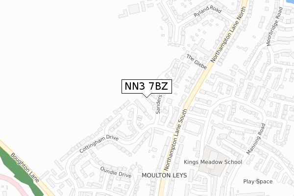
NN3 7BZ is located in the Moulton electoral ward, within the unitary authority of West Northamptonshire and the English Parliamentary constituency of Daventry. The Sub Integrated Care Board (ICB) Location is NHS Northamptonshire ICB - 78H and the police force is Northamptonshire. This postcode has been in use since September 2018.


GetTheData
Source: OS Open Zoomstack (Ordnance Survey)
Licence: Open Government Licence (requires attribution)
Attribution: Contains OS data © Crown copyright and database right 2025
Source: Open Postcode Geo
Licence: Open Government Licence (requires attribution)
Attribution: Contains OS data © Crown copyright and database right 2025; Contains Royal Mail data © Royal Mail copyright and database right 2025; Source: Office for National Statistics licensed under the Open Government Licence v.3.0
| Easting | 477928 |
| Northing | 265368 |
| Latitude | 52.280957 |
| Longitude | -0.859116 |
GetTheData
Source: Open Postcode Geo
Licence: Open Government Licence
| Country | England |
| Postcode District | NN3 |
➜ See where NN3 is on a map ➜ Where is Moulton? | |
GetTheData
Source: Land Registry Price Paid Data
Licence: Open Government Licence
| Ward | Moulton |
| Constituency | Daventry |
GetTheData
Source: ONS Postcode Database
Licence: Open Government Licence
2, STANTON CLOSE, MOULTON, NORTHAMPTON, NN3 7BZ 2018 21 DEC £385,000 |
GetTheData
Source: HM Land Registry Price Paid Data
Licence: Contains HM Land Registry data © Crown copyright and database right 2025. This data is licensed under the Open Government Licence v3.0.
| Manning Court (Manning Road) | Moulton Leys | 168m |
| Manning Court (Manning Road) | Moulton Leys | 185m |
| Cottingham Drive (Northampton Lane South) | Moulton Leys | 193m |
| Cottingham Drive (Northampton Lane South) | Moulton Leys | 223m |
| Ryland Road (Northampton Lane South) | Moulton | 326m |
| Northampton Station | 5.8km |
GetTheData
Source: NaPTAN
Licence: Open Government Licence
| Percentage of properties with Next Generation Access | 100.0% |
| Percentage of properties with Superfast Broadband | 100.0% |
| Percentage of properties with Ultrafast Broadband | 100.0% |
| Percentage of properties with Full Fibre Broadband | 100.0% |
Superfast Broadband is between 30Mbps and 300Mbps
Ultrafast Broadband is > 300Mbps
| Percentage of properties unable to receive 2Mbps | 0.0% |
| Percentage of properties unable to receive 5Mbps | 0.0% |
| Percentage of properties unable to receive 10Mbps | 0.0% |
| Percentage of properties unable to receive 30Mbps | 0.0% |
GetTheData
Source: Ofcom
Licence: Ofcom Terms of Use (requires attribution)
GetTheData
Source: ONS Postcode Database
Licence: Open Government Licence


➜ Get more ratings from the Food Standards Agency
GetTheData
Source: Food Standards Agency
Licence: FSA terms & conditions
| Last Collection | |||
|---|---|---|---|
| Location | Mon-Fri | Sat | Distance |
| Northampton Lane | 17:30 | 09:30 | 346m |
| Manning Road | 17:30 | 09:30 | 394m |
| Three Ways | 17:30 | 11:30 | 441m |
GetTheData
Source: Dracos
Licence: Creative Commons Attribution-ShareAlike
The below table lists the International Territorial Level (ITL) codes (formerly Nomenclature of Territorial Units for Statistics (NUTS) codes) and Local Administrative Units (LAU) codes for NN3 7BZ:
| ITL 1 Code | Name |
|---|---|
| TLF | East Midlands (England) |
| ITL 2 Code | Name |
| TLF2 | Leicestershire, Rutland and Northamptonshire |
| ITL 3 Code | Name |
| TLF24 | West Northamptonshire |
| LAU 1 Code | Name |
| E07000151 | Daventry |
GetTheData
Source: ONS Postcode Directory
Licence: Open Government Licence
The below table lists the Census Output Area (OA), Lower Layer Super Output Area (LSOA), and Middle Layer Super Output Area (MSOA) for NN3 7BZ:
| Code | Name | |
|---|---|---|
| OA | E00137413 | |
| LSOA | E01027020 | Daventry 005D |
| MSOA | E02005623 | Daventry 005 |
GetTheData
Source: ONS Postcode Directory
Licence: Open Government Licence
| NN3 7LQ | Gayhurst Close | 78m |
| NN3 7BB | Southcourt | 82m |
| NN3 7LH | Medbourne Close | 146m |
| NN3 7LG | Cottingham Drive | 148m |
| NN3 7RH | Northampton Lane South | 156m |
| NN3 7LJ | Old Orchard Lane Cottingham Drive | 175m |
| NN3 7UJ | Edges Court | 183m |
| NN3 7HE | Manning Court | 196m |
| NN3 7DG | The Glebe | 206m |
| NN3 7RD | Greenwood Close | 237m |
GetTheData
Source: Open Postcode Geo; Land Registry Price Paid Data
Licence: Open Government Licence