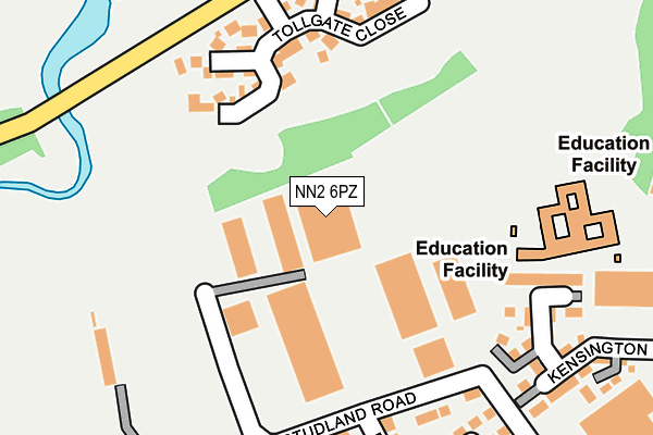
NN2 6PZ is located in the Kingsthorpe South electoral ward, within the unitary authority of West Northamptonshire and the English Parliamentary constituency of Northampton North. The Sub Integrated Care Board (ICB) Location is NHS Northamptonshire ICB - 78H and the police force is Northamptonshire. This postcode has been in use since January 1991.


GetTheData
Source: OS OpenMap – Local (Ordnance Survey)
Source: OS VectorMap District (Ordnance Survey)
Licence: Open Government Licence (requires attribution)
| Easting | 474805 |
| Northing | 262593 |
| Latitude | 52.256432 |
| Longitude | -0.905514 |
GetTheData
Source: Open Postcode Geo
Licence: Open Government Licence
| Country | England |
| Postcode District | NN2 |
➜ See where NN2 is on a map ➜ Where is Northampton? | |
GetTheData
Source: Land Registry Price Paid Data
Licence: Open Government Licence
Elevation or altitude of NN2 6PZ as distance above sea level:
| Metres | Feet | |
|---|---|---|
| Elevation | 70m | 230ft |
Elevation is measured from the approximate centre of the postcode, to the nearest point on an OS contour line from OS Terrain 50, which has contour spacing of ten vertical metres.
➜ How high above sea level am I? Find the elevation of your current position using your device's GPS.
GetTheData
Source: Open Postcode Elevation
Licence: Open Government Licence
| Ward | Kingsthorpe South |
| Constituency | Northampton North |
GetTheData
Source: ONS Postcode Database
Licence: Open Government Licence
| Grose's Garage (Queens Park Parade) | Queens Park | 335m |
| Grose's Garage (Queens Park Parade) | Queens Park | 361m |
| The Cock Ph (Mill Lane) | Kingsthorpe | 431m |
| The Cock Ph (Harborough Road) | Kingsthorpe | 461m |
| Balmoral Road (Kingsthorpe Road) | Kingsthorpe Hollow | 497m |
| Northampton Station | 2.1km |
GetTheData
Source: NaPTAN
Licence: Open Government Licence
GetTheData
Source: ONS Postcode Database
Licence: Open Government Licence


➜ Get more ratings from the Food Standards Agency
GetTheData
Source: Food Standards Agency
Licence: FSA terms & conditions
| Last Collection | |||
|---|---|---|---|
| Location | Mon-Fri | Sat | Distance |
| Queens Park Parade | 17:30 | 11:30 | 353m |
| Kingsthorpe Green | 17:30 | 11:30 | 523m |
| Cock Hotel | 17:30 | 12:00 | 531m |
GetTheData
Source: Dracos
Licence: Creative Commons Attribution-ShareAlike
The below table lists the International Territorial Level (ITL) codes (formerly Nomenclature of Territorial Units for Statistics (NUTS) codes) and Local Administrative Units (LAU) codes for NN2 6PZ:
| ITL 1 Code | Name |
|---|---|
| TLF | East Midlands (England) |
| ITL 2 Code | Name |
| TLF2 | Leicestershire, Rutland and Northamptonshire |
| ITL 3 Code | Name |
| TLF24 | West Northamptonshire |
| LAU 1 Code | Name |
| E07000154 | Northampton |
GetTheData
Source: ONS Postcode Directory
Licence: Open Government Licence
The below table lists the Census Output Area (OA), Lower Layer Super Output Area (LSOA), and Middle Layer Super Output Area (MSOA) for NN2 6PZ:
| Code | Name | |
|---|---|---|
| OA | E00138324 | |
| LSOA | E01027190 | Northampton 008A |
| MSOA | E02005657 | Northampton 008 |
GetTheData
Source: ONS Postcode Directory
Licence: Open Government Licence
| NN2 6NE | Studland Road | 147m |
| NN2 6RP | Tollgate Close | 161m |
| NN2 6NP | Kensington Close | 231m |
| NN2 6ND | Branksome Avenue | 273m |
| NN2 6LZ | Bembridge Drive | 288m |
| NN2 6RQ | Mill Lane | 311m |
| NN2 6LY | Motspur Drive | 348m |
| NN2 6PT | Thornton Hall Close | 353m |
| NN2 6LP | Queens Park Parade | 377m |
| NN2 6LR | Queens Park Parade | 377m |
GetTheData
Source: Open Postcode Geo; Land Registry Price Paid Data
Licence: Open Government Licence