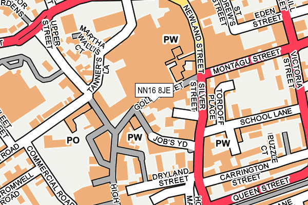
NN16 8JE is located in the Northall electoral ward, within the unitary authority of North Northamptonshire and the English Parliamentary constituency of Kettering. The Sub Integrated Care Board (ICB) Location is NHS Northamptonshire ICB - 78H and the police force is Northamptonshire. This postcode has been in use since January 1980.


GetTheData
Source: OS OpenMap – Local (Ordnance Survey)
Source: OS VectorMap District (Ordnance Survey)
Licence: Open Government Licence (requires attribution)
| Easting | 486698 |
| Northing | 278813 |
| Latitude | 52.400488 |
| Longitude | -0.727130 |
GetTheData
Source: Open Postcode Geo
Licence: Open Government Licence
| Country | England |
| Postcode District | NN16 |
➜ See where NN16 is on a map ➜ Where is Kettering? | |
GetTheData
Source: Land Registry Price Paid Data
Licence: Open Government Licence
Elevation or altitude of NN16 8JE as distance above sea level:
| Metres | Feet | |
|---|---|---|
| Elevation | 90m | 295ft |
Elevation is measured from the approximate centre of the postcode, to the nearest point on an OS contour line from OS Terrain 50, which has contour spacing of ten vertical metres.
➜ How high above sea level am I? Find the elevation of your current position using your device's GPS.
GetTheData
Source: Open Postcode Elevation
Licence: Open Government Licence
| Ward | Northall |
| Constituency | Kettering |
GetTheData
Source: ONS Postcode Database
Licence: Open Government Licence
| Newland Centre (Newland Street) | Kettering | 136m |
| Mattha Wallis Court (Tanners Lane) | Kettering | 138m |
| Newland Centre (Newland Street) | Kettering | 148m |
| Newland Centre (Newland Street) | Kettering | 158m |
| Newland Centre (Newland Street) | Kettering | 167m |
| Kettering Station | 0.8km |
GetTheData
Source: NaPTAN
Licence: Open Government Licence
GetTheData
Source: ONS Postcode Database
Licence: Open Government Licence


➜ Get more ratings from the Food Standards Agency
GetTheData
Source: Food Standards Agency
Licence: FSA terms & conditions
| Last Collection | |||
|---|---|---|---|
| Location | Mon-Fri | Sat | Distance |
| Pytchley Lodge Road | 18:30 | 158m | |
| Green Lane | 17:15 | 12:15 | 319m |
| Ivy Road | 17:15 | 12:00 | 380m |
GetTheData
Source: Dracos
Licence: Creative Commons Attribution-ShareAlike
The below table lists the International Territorial Level (ITL) codes (formerly Nomenclature of Territorial Units for Statistics (NUTS) codes) and Local Administrative Units (LAU) codes for NN16 8JE:
| ITL 1 Code | Name |
|---|---|
| TLF | East Midlands (England) |
| ITL 2 Code | Name |
| TLF2 | Leicestershire, Rutland and Northamptonshire |
| ITL 3 Code | Name |
| TLF25 | North Northamptonshire |
| LAU 1 Code | Name |
| E07000153 | Kettering |
GetTheData
Source: ONS Postcode Directory
Licence: Open Government Licence
The below table lists the Census Output Area (OA), Lower Layer Super Output Area (LSOA), and Middle Layer Super Output Area (MSOA) for NN16 8JE:
| Code | Name | |
|---|---|---|
| OA | E00137912 | |
| LSOA | E01027110 | Kettering 007B |
| MSOA | E02005645 | Kettering 007 |
GetTheData
Source: ONS Postcode Directory
Licence: Open Government Licence
| NN16 8JB | Gold Street | 38m |
| NN16 0BL | Meeting Lane | 40m |
| NN16 0BN | Silver Street | 77m |
| NN16 8SY | High Street | 102m |
| NN16 8SA | High Street | 108m |
| NN16 8SX | High Street | 132m |
| NN16 0DR | Lahnstein Court | 142m |
| NN16 8JH | Newland Street | 147m |
| NN16 0BS | Dalkeith Place | 150m |
| NN16 0BP | British Lane | 161m |
GetTheData
Source: Open Postcode Geo; Land Registry Price Paid Data
Licence: Open Government Licence