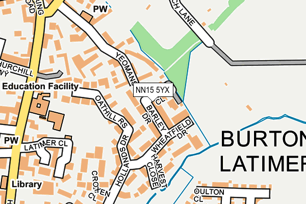
NN15 5YX is located in the Ise electoral ward, within the unitary authority of North Northamptonshire and the English Parliamentary constituency of Kettering. The Sub Integrated Care Board (ICB) Location is NHS Northamptonshire ICB - 78H and the police force is Northamptonshire. This postcode has been in use since May 2017.


GetTheData
Source: OS OpenMap – Local (Ordnance Survey)
Source: OS VectorMap District (Ordnance Survey)
Licence: Open Government Licence (requires attribution)
| Easting | 489704 |
| Northing | 278162 |
| Latitude | 52.394154 |
| Longitude | -0.683134 |
GetTheData
Source: Open Postcode Geo
Licence: Open Government Licence
| Country | England |
| Postcode District | NN15 |
➜ See where NN15 is on a map ➜ Where is Kettering? | |
GetTheData
Source: Land Registry Price Paid Data
Licence: Open Government Licence
| Ward | Ise |
| Constituency | Kettering |
GetTheData
Source: ONS Postcode Database
Licence: Open Government Licence
2021 26 MAY £362,000 |
2020 27 NOV £245,000 |
2019 14 OCT £349,995 |
32, CLAYDON AVENUE, BARTON SEAGRAVE, KETTERING, NN15 5YX 2019 27 SEP £319,995 |
25, CLAYDON AVENUE, BARTON SEAGRAVE, KETTERING, NN15 5YX 2019 26 SEP £399,995 |
22, CLAYDON AVENUE, BARTON SEAGRAVE, KETTERING, NN15 5YX 2019 5 AUG £390,995 |
23, CLAYDON AVENUE, BARTON SEAGRAVE, KETTERING, NN15 5YX 2018 27 APR £358,495 |
2017 29 SEP £279,995 |
2, CLAYDON AVENUE, BARTON SEAGRAVE, KETTERING, NN15 5YX 2017 30 JUN £408,995 |
GetTheData
Source: HM Land Registry Price Paid Data
Licence: Contains HM Land Registry data © Crown copyright and database right 2025. This data is licensed under the Open Government Licence v3.0.
| St Stephens Road (Deeble Road) | Kettering | 401m |
| St Stephens Road (Deeble Road) | Kettering | 407m |
| The Leather Craftsman Ph (St Stephen's Rd) | Kettering | 438m |
| 42 St Stephens Road (St Stephens Road) | Kettering | 476m |
| St Lukes Close (St Johns Road) | Kettering | 501m |
| Kettering Station | 3.3km |
GetTheData
Source: NaPTAN
Licence: Open Government Licence
| Percentage of properties with Next Generation Access | 97.6% |
| Percentage of properties with Superfast Broadband | 97.6% |
| Percentage of properties with Ultrafast Broadband | 97.6% |
| Percentage of properties with Full Fibre Broadband | 97.6% |
Superfast Broadband is between 30Mbps and 300Mbps
Ultrafast Broadband is > 300Mbps
| Percentage of properties unable to receive 2Mbps | 0.0% |
| Percentage of properties unable to receive 5Mbps | 2.4% |
| Percentage of properties unable to receive 10Mbps | 2.4% |
| Percentage of properties unable to receive 30Mbps | 2.4% |
GetTheData
Source: Ofcom
Licence: Ofcom Terms of Use (requires attribution)
GetTheData
Source: ONS Postcode Database
Licence: Open Government Licence


➜ Get more ratings from the Food Standards Agency
GetTheData
Source: Food Standards Agency
Licence: FSA terms & conditions
| Last Collection | |||
|---|---|---|---|
| Location | Mon-Fri | Sat | Distance |
| St Johns Road | 17:15 | 11:30 | 677m |
| Barton Seagrave Tso | 17:30 | 11:00 | 1,405m |
| 17 Lower Street | 19:00 | 12:30 | 1,562m |
GetTheData
Source: Dracos
Licence: Creative Commons Attribution-ShareAlike
The below table lists the International Territorial Level (ITL) codes (formerly Nomenclature of Territorial Units for Statistics (NUTS) codes) and Local Administrative Units (LAU) codes for NN15 5YX:
| ITL 1 Code | Name |
|---|---|
| TLF | East Midlands (England) |
| ITL 2 Code | Name |
| TLF2 | Leicestershire, Rutland and Northamptonshire |
| ITL 3 Code | Name |
| TLF25 | North Northamptonshire |
| LAU 1 Code | Name |
| E07000153 | Kettering |
GetTheData
Source: ONS Postcode Directory
Licence: Open Government Licence
The below table lists the Census Output Area (OA), Lower Layer Super Output Area (LSOA), and Middle Layer Super Output Area (MSOA) for NN15 5YX:
| Code | Name | |
|---|---|---|
| OA | E00137967 | |
| LSOA | E01027121 | Kettering 010E |
| MSOA | E02005648 | Kettering 010 |
GetTheData
Source: ONS Postcode Directory
Licence: Open Government Licence
| NN15 5AD | Warkton Lane | 225m |
| NN15 5AP | Warkton Lane | 236m |
| NN15 5EJ | St Saviours Road | 248m |
| NN15 5DX | St Simons Close | 254m |
| NN15 5EL | St Saviours Road | 294m |
| NN15 5DT | St Francis Close | 327m |
| NN15 5DU | St Philips Close | 330m |
| NN15 5HN | Deeble Road | 344m |
| NN15 5HJ | St Johns Road | 371m |
| NN15 5EE | St Catherines Road | 402m |
GetTheData
Source: Open Postcode Geo; Land Registry Price Paid Data
Licence: Open Government Licence