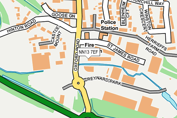
NN13 7EF lies on Oxford Road in Brackley. NN13 7EF is located in the Brackley electoral ward, within the unitary authority of West Northamptonshire and the English Parliamentary constituency of South Northamptonshire. The Sub Integrated Care Board (ICB) Location is NHS Northamptonshire ICB - 78H and the police force is Northamptonshire. This postcode has been in use since August 1993.


GetTheData
Source: OS OpenMap – Local (Ordnance Survey)
Source: OS VectorMap District (Ordnance Survey)
Licence: Open Government Licence (requires attribution)
| Easting | 458458 |
| Northing | 236429 |
| Latitude | 52.023207 |
| Longitude | -1.149458 |
GetTheData
Source: Open Postcode Geo
Licence: Open Government Licence
| Street | Oxford Road |
| Town/City | Brackley |
| Country | England |
| Postcode District | NN13 |
➜ See where NN13 is on a map ➜ Where is Brackley? | |
GetTheData
Source: Land Registry Price Paid Data
Licence: Open Government Licence
Elevation or altitude of NN13 7EF as distance above sea level:
| Metres | Feet | |
|---|---|---|
| Elevation | 110m | 361ft |
Elevation is measured from the approximate centre of the postcode, to the nearest point on an OS contour line from OS Terrain 50, which has contour spacing of ten vertical metres.
➜ How high above sea level am I? Find the elevation of your current position using your device's GPS.
GetTheData
Source: Open Postcode Elevation
Licence: Open Government Licence
| Ward | Brackley |
| Constituency | South Northamptonshire |
GetTheData
Source: ONS Postcode Database
Licence: Open Government Licence
| Tesco (Oxford Road) | Brackley | 38m |
| Tesco (Oxford Road) | Brackley | 64m |
| Tesco Store Car Park (Oxford Road) | Brackley | 161m |
| Churchill Way (Bridge Street) | Brackley | 204m |
| Churchill Way | Brackley | 244m |
GetTheData
Source: NaPTAN
Licence: Open Government Licence
Estimated total energy consumption in NN13 7EF by fuel type, 2015.
| Consumption (kWh) | 157,751 |
|---|---|
| Meter count | 12 |
| Mean (kWh/meter) | 13,146 |
| Median (kWh/meter) | 6,135 |
GetTheData
Source: Postcode level gas estimates: 2015 (experimental)
Source: Postcode level electricity estimates: 2015 (experimental)
Licence: Open Government Licence
GetTheData
Source: ONS Postcode Database
Licence: Open Government Licence


➜ Get more ratings from the Food Standards Agency
GetTheData
Source: Food Standards Agency
Licence: FSA terms & conditions
| Last Collection | |||
|---|---|---|---|
| Location | Mon-Fri | Sat | Distance |
| Tesco | 16:30 | 12:00 | 84m |
| Market Square | 17:00 | 12:00 | 494m |
| Banbury Road | 16:45 | 08:00 | 641m |
GetTheData
Source: Dracos
Licence: Creative Commons Attribution-ShareAlike
The below table lists the International Territorial Level (ITL) codes (formerly Nomenclature of Territorial Units for Statistics (NUTS) codes) and Local Administrative Units (LAU) codes for NN13 7EF:
| ITL 1 Code | Name |
|---|---|
| TLF | East Midlands (England) |
| ITL 2 Code | Name |
| TLF2 | Leicestershire, Rutland and Northamptonshire |
| ITL 3 Code | Name |
| TLF24 | West Northamptonshire |
| LAU 1 Code | Name |
| E07000155 | South Northamptonshire |
GetTheData
Source: ONS Postcode Directory
Licence: Open Government Licence
The below table lists the Census Output Area (OA), Lower Layer Super Output Area (LSOA), and Middle Layer Super Output Area (MSOA) for NN13 7EF:
| Code | Name | |
|---|---|---|
| OA | E00138704 | |
| LSOA | E01027264 | South Northamptonshire 010A |
| MSOA | E02005690 | South Northamptonshire 010 |
GetTheData
Source: ONS Postcode Directory
Licence: Open Government Licence
| NN13 7FD | Oxford Road | 90m |
| NN13 7XY | St James Road | 119m |
| NN13 7EW | Bridge Street | 137m |
| NN13 7HF | Castle Mount | 146m |
| NN13 7ET | Blenheim Croft | 168m |
| NN13 7EG | Marlborough Croft | 170m |
| NN13 7TA | Herrieffs Farm Road | 182m |
| NN13 7GG | Goose Green | 189m |
| NN13 7HA | Bridge Street | 190m |
| NN13 7EH | Churchill Way | 216m |
GetTheData
Source: Open Postcode Geo; Land Registry Price Paid Data
Licence: Open Government Licence