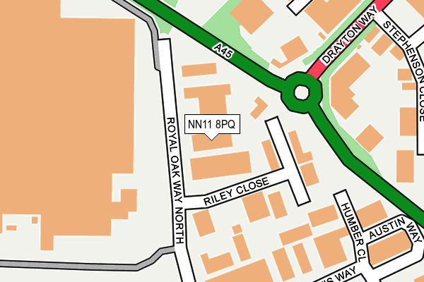
NN11 8PQ lies on Royal Oak Way North in Royal Oak Industrial Estate, Daventry. NN11 8PQ is located in the Daventry West electoral ward, within the unitary authority of West Northamptonshire and the English Parliamentary constituency of Daventry. The Sub Integrated Care Board (ICB) Location is NHS Northamptonshire ICB - 78H and the police force is Northamptonshire. This postcode has been in use since September 2004.


GetTheData
Source: OS OpenMap – Local (Ordnance Survey)
Source: OS VectorMap District (Ordnance Survey)
Licence: Open Government Licence (requires attribution)
| Easting | 455671 |
| Northing | 263635 |
| Latitude | 52.268080 |
| Longitude | -1.185608 |
GetTheData
Source: Open Postcode Geo
Licence: Open Government Licence
| Street | Royal Oak Way North |
| Locality | Royal Oak Industrial Estate |
| Town/City | Daventry |
| Country | England |
| Postcode District | NN11 |
➜ See where NN11 is on a map ➜ Where is Daventry? | |
GetTheData
Source: Land Registry Price Paid Data
Licence: Open Government Licence
Elevation or altitude of NN11 8PQ as distance above sea level:
| Metres | Feet | |
|---|---|---|
| Elevation | 170m | 558ft |
Elevation is measured from the approximate centre of the postcode, to the nearest point on an OS contour line from OS Terrain 50, which has contour spacing of ten vertical metres.
➜ How high above sea level am I? Find the elevation of your current position using your device's GPS.
GetTheData
Source: Open Postcode Elevation
Licence: Open Government Licence
| Ward | Daventry West |
| Constituency | Daventry |
GetTheData
Source: ONS Postcode Database
Licence: Open Government Licence
OAK HOUSE, ROYAL OAK WAY NORTH, ROYAL OAK INDUSTRIAL ESTATE, DAVENTRY, NN11 8PQ 2004 26 NOV £115,000 |
OAK HOUSE, ROYAL OAK WAY NORTH, ROYAL OAK INDUSTRIAL ESTATE, DAVENTRY, NN11 8PQ 2002 2 OCT £110,000 |
GetTheData
Source: HM Land Registry Price Paid Data
Licence: Contains HM Land Registry data © Crown copyright and database right 2025. This data is licensed under the Open Government Licence v3.0.
| Royal Oak Industry Estate (Braunston Road) | Daventry | 244m |
| Stephenson Close (Drayton Way) | Daventry | 326m |
| Stephenson Close (Drayton Way) | Daventry | 326m |
| Royal Oak Industry Estate (Braunston Road) | Daventry | 334m |
| Bentley Way (Prospect Way) | Daventry | 431m |
GetTheData
Source: NaPTAN
Licence: Open Government Licence
| Median download speed | 4.3Mbps |
| Average download speed | 5.1Mbps |
| Maximum download speed | 11.19Mbps |
| Median upload speed | 0.9Mbps |
| Average upload speed | 0.9Mbps |
| Maximum upload speed | 1.19Mbps |
GetTheData
Source: Ofcom
Licence: Ofcom Terms of Use (requires attribution)
GetTheData
Source: ONS Postcode Database
Licence: Open Government Licence


➜ Get more ratings from the Food Standards Agency
GetTheData
Source: Food Standards Agency
Licence: FSA terms & conditions
| Last Collection | |||
|---|---|---|---|
| Location | Mon-Fri | Sat | Distance |
| Prospect Way | 18:30 | 427m | |
| Braunstton Sub | 16:15 | 08:00 | 3,024m |
| Church Road | 16:15 | 07:45 | 3,207m |
GetTheData
Source: Dracos
Licence: Creative Commons Attribution-ShareAlike
The below table lists the International Territorial Level (ITL) codes (formerly Nomenclature of Territorial Units for Statistics (NUTS) codes) and Local Administrative Units (LAU) codes for NN11 8PQ:
| ITL 1 Code | Name |
|---|---|
| TLF | East Midlands (England) |
| ITL 2 Code | Name |
| TLF2 | Leicestershire, Rutland and Northamptonshire |
| ITL 3 Code | Name |
| TLF24 | West Northamptonshire |
| LAU 1 Code | Name |
| E07000151 | Daventry |
GetTheData
Source: ONS Postcode Directory
Licence: Open Government Licence
The below table lists the Census Output Area (OA), Lower Layer Super Output Area (LSOA), and Middle Layer Super Output Area (MSOA) for NN11 8PQ:
| Code | Name | |
|---|---|---|
| OA | E00137370 | |
| LSOA | E01027009 | Daventry 008C |
| MSOA | E02005626 | Daventry 008 |
GetTheData
Source: ONS Postcode Directory
Licence: Open Government Licence
| NN11 8QT | Riley Close | 90m |
| NN11 8RF | Stephenson Close | 280m |
| NN11 8XW | Rutherford Way | 363m |
| NN11 8RJ | James Watt Close | 364m |
| NN11 8RB | Brunel Close | 420m |
| NN11 8RT | Caxton Close | 421m |
| NN11 9UE | Timken Way | 428m |
| NN11 9UQ | Timken Way | 432m |
| NN11 9UR | Timken Way | 459m |
| NN11 9UB | Timken Way | 468m |
GetTheData
Source: Open Postcode Geo; Land Registry Price Paid Data
Licence: Open Government Licence