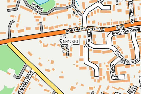
NN10 6FJ is located in the Higham Ferrers electoral ward, within the unitary authority of North Northamptonshire and the English Parliamentary constituency of Wellingborough. The Sub Integrated Care Board (ICB) Location is NHS Northamptonshire ICB - 78H and the police force is Northamptonshire. This postcode has been in use since July 2017.


GetTheData
Source: OS OpenMap – Local (Ordnance Survey)
Source: OS VectorMap District (Ordnance Survey)
Licence: Open Government Licence (requires attribution)
| Easting | 495317 |
| Northing | 267925 |
| Latitude | 52.301201 |
| Longitude | -0.603574 |
GetTheData
Source: Open Postcode Geo
Licence: Open Government Licence
| Country | England |
| Postcode District | NN10 |
➜ See where NN10 is on a map ➜ Where is Rushden? | |
GetTheData
Source: Land Registry Price Paid Data
Licence: Open Government Licence
| Ward | Higham Ferrers |
| Constituency | Wellingborough |
GetTheData
Source: ONS Postcode Database
Licence: Open Government Licence
4, CORRINA GARDENS, RUSHDEN, NN10 6FJ 2018 9 APR £420,000 |
2, CORRINA GARDENS, RUSHDEN, NN10 6FJ 2017 1 DEC £495,000 |
3, CORRINA GARDENS, RUSHDEN, NN10 6FJ 2017 3 NOV £462,500 |
1, CORINNA GARDENS, RUSHDEN, NN10 6FJ 2017 21 JUL £385,000 |
GetTheData
Source: HM Land Registry Price Paid Data
Licence: Contains HM Land Registry data © Crown copyright and database right 2024. This data is licensed under the Open Government Licence v3.0.
| Kilburn Place (Higham Road) | Rushden | 443m |
| Kilburn Place (Higham Road) | Rushden | 454m |
| Hayway (Higham Road) | Rushden | 514m |
| Northampton Road (Higham Road) | Higham Ferrers | 532m |
| Northampton Road (Higham Road) | Higham Ferrers | 539m |
| Wellingborough Station | 5km |
GetTheData
Source: NaPTAN
Licence: Open Government Licence
| Percentage of properties with Next Generation Access | 100.0% |
| Percentage of properties with Superfast Broadband | 100.0% |
| Percentage of properties with Ultrafast Broadband | 0.0% |
| Percentage of properties with Full Fibre Broadband | 0.0% |
Superfast Broadband is between 30Mbps and 300Mbps
Ultrafast Broadband is > 300Mbps
| Percentage of properties unable to receive 2Mbps | 0.0% |
| Percentage of properties unable to receive 5Mbps | 0.0% |
| Percentage of properties unable to receive 10Mbps | 0.0% |
| Percentage of properties unable to receive 30Mbps | 0.0% |
GetTheData
Source: Ofcom
Licence: Ofcom Terms of Use (requires attribution)
GetTheData
Source: ONS Postcode Database
Licence: Open Government Licence


➜ Get more ratings from the Food Standards Agency
GetTheData
Source: Food Standards Agency
Licence: FSA terms & conditions
| Last Collection | |||
|---|---|---|---|
| Location | Mon-Fri | Sat | Distance |
| Larkhill | 17:00 | 11:00 | 94m |
| South End | 17:15 | 11:15 | 536m |
| Wharf Road Tso | 17:15 | 11:15 | 810m |
GetTheData
Source: Dracos
Licence: Creative Commons Attribution-ShareAlike
The below table lists the International Territorial Level (ITL) codes (formerly Nomenclature of Territorial Units for Statistics (NUTS) codes) and Local Administrative Units (LAU) codes for NN10 6FJ:
| ITL 1 Code | Name |
|---|---|
| TLF | East Midlands (England) |
| ITL 2 Code | Name |
| TLF2 | Leicestershire, Rutland and Northamptonshire |
| ITL 3 Code | Name |
| TLF25 | North Northamptonshire |
| LAU 1 Code | Name |
| E07000152 | East Northamptonshire |
GetTheData
Source: ONS Postcode Directory
Licence: Open Government Licence
The below table lists the Census Output Area (OA), Lower Layer Super Output Area (LSOA), and Middle Layer Super Output Area (MSOA) for NN10 6FJ:
| Code | Name | |
|---|---|---|
| OA | E00172235 | |
| LSOA | E01027063 | East Northamptonshire 008C |
| MSOA | E02005636 | East Northamptonshire 008 |
GetTheData
Source: ONS Postcode Directory
Licence: Open Government Licence
| NN10 6AJ | Northampton Road | 28m |
| NN10 6BG | Larkhill | 133m |
| NN10 6AL | Northampton Road | 145m |
| NN10 8PB | Owen Way | 153m |
| NN10 6AQ | Hayway | 205m |
| NN10 6EG | Swallow Drive | 215m |
| NN10 6EL | Oakfield | 236m |
| NN10 6YZ | Martin Close | 241m |
| NN10 8PF | Donne Close | 243m |
| NN10 6YB | Rushmere Way | 244m |
GetTheData
Source: Open Postcode Geo; Land Registry Price Paid Data
Licence: Open Government Licence