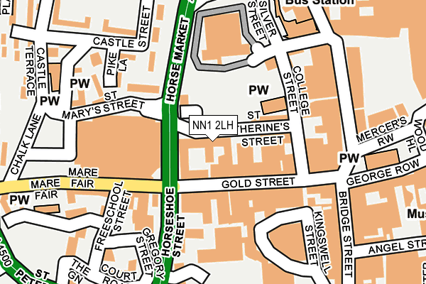
NN1 2LH is located in the Castle electoral ward, within the unitary authority of West Northamptonshire and the English Parliamentary constituency of Northampton South. The Sub Integrated Care Board (ICB) Location is NHS Northamptonshire ICB - 78H and the police force is Northamptonshire. This postcode has been in use since August 1992.


GetTheData
Source: OS OpenMap – Local (Ordnance Survey)
Source: OS VectorMap District (Ordnance Survey)
Licence: Open Government Licence (requires attribution)
| Easting | 475216 |
| Northing | 260471 |
| Latitude | 52.237302 |
| Longitude | -0.899965 |
GetTheData
Source: Open Postcode Geo
Licence: Open Government Licence
| Country | England |
| Postcode District | NN1 |
➜ See where NN1 is on a map ➜ Where is Northampton? | |
GetTheData
Source: Land Registry Price Paid Data
Licence: Open Government Licence
Elevation or altitude of NN1 2LH as distance above sea level:
| Metres | Feet | |
|---|---|---|
| Elevation | 70m | 230ft |
Elevation is measured from the approximate centre of the postcode, to the nearest point on an OS contour line from OS Terrain 50, which has contour spacing of ten vertical metres.
➜ How high above sea level am I? Find the elevation of your current position using your device's GPS.
GetTheData
Source: Open Postcode Elevation
Licence: Open Government Licence
| Ward | Castle |
| Constituency | Northampton South |
GetTheData
Source: ONS Postcode Database
Licence: Open Government Licence
| St Peters Walk (Gold Street) | Northampton | 68m |
| Marefair (Horsemarket) | Northampton | 76m |
| Sol Central (Marefair) | Northampton | 134m |
| Sol Central (Marefair) | Northampton | 142m |
| Drapery | Northampton | 184m |
| Northampton Station | 0.5km |
GetTheData
Source: NaPTAN
Licence: Open Government Licence
GetTheData
Source: ONS Postcode Database
Licence: Open Government Licence


➜ Get more ratings from the Food Standards Agency
GetTheData
Source: Food Standards Agency
Licence: FSA terms & conditions
| Last Collection | |||
|---|---|---|---|
| Location | Mon-Fri | Sat | Distance |
| Marefair | 17:30 | 12:45 | 142m |
| Drapery | 18:45 | 11:30 | 196m |
| The Parade | 18:45 | 11:30 | 283m |
GetTheData
Source: Dracos
Licence: Creative Commons Attribution-ShareAlike
The below table lists the International Territorial Level (ITL) codes (formerly Nomenclature of Territorial Units for Statistics (NUTS) codes) and Local Administrative Units (LAU) codes for NN1 2LH:
| ITL 1 Code | Name |
|---|---|
| TLF | East Midlands (England) |
| ITL 2 Code | Name |
| TLF2 | Leicestershire, Rutland and Northamptonshire |
| ITL 3 Code | Name |
| TLF24 | West Northamptonshire |
| LAU 1 Code | Name |
| E07000154 | Northampton |
GetTheData
Source: ONS Postcode Directory
Licence: Open Government Licence
The below table lists the Census Output Area (OA), Lower Layer Super Output Area (LSOA), and Middle Layer Super Output Area (MSOA) for NN1 2LH:
| Code | Name | |
|---|---|---|
| OA | E00169259 | |
| LSOA | E01032979 | Northampton 021F |
| MSOA | E02005670 | Northampton 021 |
GetTheData
Source: ONS Postcode Directory
Licence: Open Government Licence
| NN1 1RS | Gold Street | 52m |
| NN1 1RA | Gold Street | 86m |
| NN1 1AJ | Adelaide Place | 132m |
| NN1 2QP | College Street | 137m |
| NN1 1SR | Marefair | 150m |
| NN1 2ET | Drapery | 163m |
| NN1 1TA | Gregory Street | 167m |
| NN1 1PB | Woolmonger Street | 171m |
| NN1 1PU | Woolmonger Street | 171m |
| NN1 2RJ | Pike Lane | 173m |
GetTheData
Source: Open Postcode Geo; Land Registry Price Paid Data
Licence: Open Government Licence