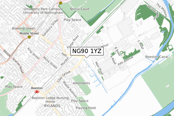
NG90 1YZ is located in the Beeston Rylands electoral ward, within the local authority district of Broxtowe and the English Parliamentary constituency of Broxtowe. The Sub Integrated Care Board (ICB) Location is NHS Nottingham and Nottinghamshire ICB - 52R and the police force is Nottinghamshire. This postcode has been in use since August 2018.


GetTheData
Source: OS Open Zoomstack (Ordnance Survey)
Licence: Open Government Licence (requires attribution)
Attribution: Contains OS data © Crown copyright and database right 2025
Source: Open Postcode Geo
Licence: Open Government Licence (requires attribution)
Attribution: Contains OS data © Crown copyright and database right 2025; Contains Royal Mail data © Royal Mail copyright and database right 2025; Source: Office for National Statistics licensed under the Open Government Licence v.3.0
| Easting | 454102 |
| Northing | 336709 |
| Latitude | 52.925095 |
| Longitude | -1.196687 |
GetTheData
Source: Open Postcode Geo
Licence: Open Government Licence
| Country | England |
| Postcode District | NG90 |
GetTheData
Source: Land Registry Price Paid Data
Licence: Open Government Licence
| Ward | Beeston Rylands |
| Constituency | Broxtowe |
GetTheData
Source: ONS Postcode Database
Licence: Open Government Licence
| Lilac Grove | Beeston Rylands | 86m |
| Lilac Grove | Beeston Rylands | 117m |
| The Parrs (Lilac Grove) | Beeston Rylands | 302m |
| The Parrs (Lilac Grove) | Beeston Rylands | 360m |
| Building D6 (First Avenue) | Boots | 374m |
| University Boulevard Tram Stop (University Boulevard) | Nottingham University Main Campus | 874m |
| Middle Street Tram Stop (Middle Street) | Beeston | 887m |
| Beeston Centre Tram Stop (Styring Street) | Beeston | 1,217m |
| University Of Nottingham Tram Stop (University Boulevard) | Nottingham University Main Campus | 1,465m |
| Beeston Station | 0.9km |
| Attenborough Station | 3.1km |
| Nottingham Station | 4.2km |
GetTheData
Source: NaPTAN
Licence: Open Government Licence
GetTheData
Source: ONS Postcode Database
Licence: Open Government Licence

➜ Get more ratings from the Food Standards Agency
GetTheData
Source: Food Standards Agency
Licence: FSA terms & conditions
| Last Collection | |||
|---|---|---|---|
| Location | Mon-Fri | Sat | Distance |
| Nottingham Mailcentre | 19:30 | 14:00 | 368m |
| Mailcentre | 371m | ||
| Lilac Grove | 17:00 | 10:30 | 475m |
GetTheData
Source: Dracos
Licence: Creative Commons Attribution-ShareAlike
The below table lists the International Territorial Level (ITL) codes (formerly Nomenclature of Territorial Units for Statistics (NUTS) codes) and Local Administrative Units (LAU) codes for NG90 1YZ:
| ITL 1 Code | Name |
|---|---|
| TLF | East Midlands (England) |
| ITL 2 Code | Name |
| TLF1 | Derbyshire and Nottinghamshire |
| ITL 3 Code | Name |
| TLF16 | South Nottinghamshire |
| LAU 1 Code | Name |
| E07000172 | Broxtowe |
GetTheData
Source: ONS Postcode Directory
Licence: Open Government Licence
The below table lists the Census Output Area (OA), Lower Layer Super Output Area (LSOA), and Middle Layer Super Output Area (MSOA) for NG90 1YZ:
| Code | Name | |
|---|---|---|
| OA | E00143090 | |
| LSOA | E01028083 | Broxtowe 012D |
| MSOA | E02005861 | Broxtowe 012 |
GetTheData
Source: ONS Postcode Directory
Licence: Open Government Licence
| NG9 1PF | Lilac Grove | 352m |
| NG9 2WF | Murden Way | 362m |
| NG9 1PN | Technology Drive | 367m |
| NG9 2DX | Templar Road | 379m |
| NG9 2EY | Beacon Road | 381m |
| NG9 2WB | Eaton Close | 385m |
| NG9 1PR | Leyton Crescent | 420m |
| NG9 2EZ | Dallas York Road | 434m |
| NG9 2WE | Hartley Drive | 436m |
| NG9 2WD | Gale Close | 438m |
GetTheData
Source: Open Postcode Geo; Land Registry Price Paid Data
Licence: Open Government Licence