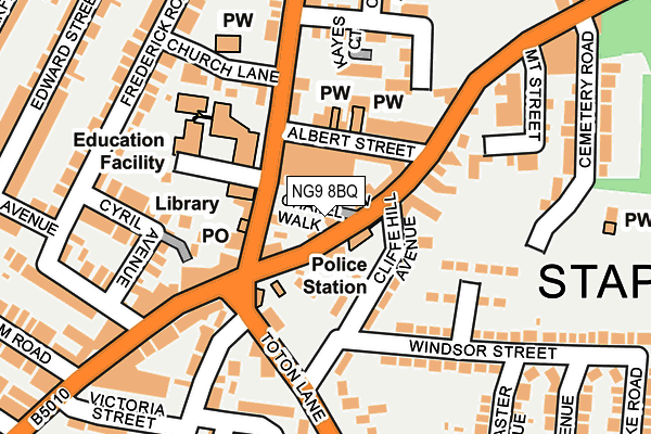
NG9 8BQ lies on Wesleyan Chapel Walk in Stapleford, Nottingham. NG9 8BQ is located in the Stapleford South East electoral ward, within the local authority district of Broxtowe and the English Parliamentary constituency of Broxtowe. The Sub Integrated Care Board (ICB) Location is NHS Nottingham and Nottinghamshire ICB - 52R and the police force is Nottinghamshire. This postcode has been in use since January 1980.


GetTheData
Source: OS OpenMap – Local (Ordnance Survey)
Source: OS VectorMap District (Ordnance Survey)
Licence: Open Government Licence (requires attribution)
| Easting | 448948 |
| Northing | 337200 |
| Latitude | 52.929982 |
| Longitude | -1.273274 |
GetTheData
Source: Open Postcode Geo
Licence: Open Government Licence
| Street | Wesleyan Chapel Walk |
| Locality | Stapleford |
| Town/City | Nottingham |
| Country | England |
| Postcode District | NG9 |
➜ See where NG9 is on a map ➜ Where is Stapleford? | |
GetTheData
Source: Land Registry Price Paid Data
Licence: Open Government Licence
Elevation or altitude of NG9 8BQ as distance above sea level:
| Metres | Feet | |
|---|---|---|
| Elevation | 50m | 164ft |
Elevation is measured from the approximate centre of the postcode, to the nearest point on an OS contour line from OS Terrain 50, which has contour spacing of ten vertical metres.
➜ How high above sea level am I? Find the elevation of your current position using your device's GPS.
GetTheData
Source: Open Postcode Elevation
Licence: Open Government Licence
| Ward | Stapleford South East |
| Constituency | Broxtowe |
GetTheData
Source: ONS Postcode Database
Licence: Open Government Licence
| Chequers Inn (Nottingham Road) | Stapleford | 65m |
| Arthur Mee Centre (Church Street) | Stapleford | 77m |
| Albert Street (Nottingham Road) | Stapleford | 94m |
| Cliffe Hill Avenue (Toton Lane) | Stapleford | 133m |
| Cliffe Hill Avenue (Toton Lane) | Stapleford | 138m |
| Toton Lane Tram Stop (Toton Lane) | Toton | 1,480m |
| Inham Road Tram Stop (Eskdale Drive) | Chilwell | 1,870m |
| Attenborough Station | 3.9km |
| Beeston Station | 4.5km |
GetTheData
Source: NaPTAN
Licence: Open Government Licence
GetTheData
Source: ONS Postcode Database
Licence: Open Government Licence

➜ Get more ratings from the Food Standards Agency
GetTheData
Source: Food Standards Agency
Licence: FSA terms & conditions
| Last Collection | |||
|---|---|---|---|
| Location | Mon-Fri | Sat | Distance |
| Stapleford Post Office | 17:15 | 12:00 | 76m |
| Mill Road | 17:15 | 12:00 | 297m |
| Warren Avenue | 17:15 | 12:00 | 316m |
GetTheData
Source: Dracos
Licence: Creative Commons Attribution-ShareAlike
The below table lists the International Territorial Level (ITL) codes (formerly Nomenclature of Territorial Units for Statistics (NUTS) codes) and Local Administrative Units (LAU) codes for NG9 8BQ:
| ITL 1 Code | Name |
|---|---|
| TLF | East Midlands (England) |
| ITL 2 Code | Name |
| TLF1 | Derbyshire and Nottinghamshire |
| ITL 3 Code | Name |
| TLF16 | South Nottinghamshire |
| LAU 1 Code | Name |
| E07000172 | Broxtowe |
GetTheData
Source: ONS Postcode Directory
Licence: Open Government Licence
The below table lists the Census Output Area (OA), Lower Layer Super Output Area (LSOA), and Middle Layer Super Output Area (MSOA) for NG9 8BQ:
| Code | Name | |
|---|---|---|
| OA | E00143332 | |
| LSOA | E01028130 | Broxtowe 010C |
| MSOA | E02005859 | Broxtowe 010 |
GetTheData
Source: ONS Postcode Directory
Licence: Open Government Licence
| NG9 8AB | Nottingham Road | 35m |
| NG9 8HJ | Church Street | 86m |
| NG9 8DB | Albert Street | 88m |
| NG9 7HD | Cliff Hill Avenue | 100m |
| NG9 8AA | Nottingham Road | 113m |
| NG9 8AD | Nottingham Road | 122m |
| NG9 8GA | Church Street | 127m |
| NG9 8DA | Church Street | 127m |
| NG9 7HA | Toton Lane | 142m |
| NG9 8DF | Upper Orchard Street | 158m |
GetTheData
Source: Open Postcode Geo; Land Registry Price Paid Data
Licence: Open Government Licence