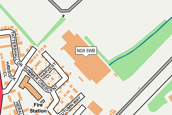
NG9 5WB is located in the Beeston Central electoral ward, within the local authority district of Broxtowe and the English Parliamentary constituency of Broxtowe. The Sub Integrated Care Board (ICB) Location is NHS Nottingham and Nottinghamshire ICB - 52R and the police force is Nottinghamshire. This postcode has been in use since April 2014.


GetTheData
Source: OS OpenMap – Local (Ordnance Survey)
Source: OS VectorMap District (Ordnance Survey)
Licence: Open Government Licence (requires attribution)
| Easting | 454020 |
| Northing | 337246 |
| Latitude | 52.929910 |
| Longitude | -1.197821 |
GetTheData
Source: Open Postcode Geo
Licence: Open Government Licence
| Country | England |
| Postcode District | NG9 |
➜ See where NG9 is on a map ➜ Where is Beeston? | |
GetTheData
Source: Land Registry Price Paid Data
Licence: Open Government Licence
Elevation or altitude of NG9 5WB as distance above sea level:
| Metres | Feet | |
|---|---|---|
| Elevation | 30m | 98ft |
Elevation is measured from the approximate centre of the postcode, to the nearest point on an OS contour line from OS Terrain 50, which has contour spacing of ten vertical metres.
➜ How high above sea level am I? Find the elevation of your current position using your device's GPS.
GetTheData
Source: Open Postcode Elevation
Licence: Open Government Licence
| Ward | Beeston Central |
| Constituency | Broxtowe |
GetTheData
Source: ONS Postcode Database
Licence: Open Government Licence
| Salisbury Street (Queens Road East) | Beeston | 322m |
| Salisbury Street (Queens Road East) | Beeston | 324m |
| Hassocks Lane (Queens Road East) | Beeston | 333m |
| Paddling Pool (University Boulevard) | Nottingham University Main Campus | 351m |
| Paddling Pool (University Boulevard) | Nottingham University Main Campus | 368m |
| University Boulevard Tram Stop (University Boulevard) | Nottingham University Main Campus | 387m |
| Middle Street Tram Stop (Middle Street) | Beeston | 790m |
| University Of Nottingham Tram Stop (University Boulevard) | Nottingham University Main Campus | 1,035m |
| Beeston Centre Tram Stop (Styring Street) | Beeston | 1,249m |
| Queens Medical Centre Tram Stop (South Road) | Queens Medical Centre | 1,694m |
| Beeston Station | 1.2km |
| Attenborough Station | 3.5km |
| Nottingham Station | 3.9km |
GetTheData
Source: NaPTAN
Licence: Open Government Licence
GetTheData
Source: ONS Postcode Database
Licence: Open Government Licence


➜ Get more ratings from the Food Standards Agency
GetTheData
Source: Food Standards Agency
Licence: FSA terms & conditions
| Last Collection | |||
|---|---|---|---|
| Location | Mon-Fri | Sat | Distance |
| Mailcentre | 174m | ||
| Nottingham Mailcentre | 19:30 | 14:00 | 177m |
| Salisbury Street | 17:30 | 11:30 | 324m |
GetTheData
Source: Dracos
Licence: Creative Commons Attribution-ShareAlike
| Risk of NG9 5WB flooding from rivers and sea | High |
| ➜ NG9 5WB flood map | |
GetTheData
Source: Open Flood Risk by Postcode
Licence: Open Government Licence
The below table lists the International Territorial Level (ITL) codes (formerly Nomenclature of Territorial Units for Statistics (NUTS) codes) and Local Administrative Units (LAU) codes for NG9 5WB:
| ITL 1 Code | Name |
|---|---|
| TLF | East Midlands (England) |
| ITL 2 Code | Name |
| TLF1 | Derbyshire and Nottinghamshire |
| ITL 3 Code | Name |
| TLF16 | South Nottinghamshire |
| LAU 1 Code | Name |
| E07000172 | Broxtowe |
GetTheData
Source: ONS Postcode Directory
Licence: Open Government Licence
The below table lists the Census Output Area (OA), Lower Layer Super Output Area (LSOA), and Middle Layer Super Output Area (MSOA) for NG9 5WB:
| Code | Name | |
|---|---|---|
| OA | E00143049 | |
| LSOA | E01028074 | Broxtowe 011B |
| MSOA | E02005860 | Broxtowe 011 |
GetTheData
Source: ONS Postcode Directory
Licence: Open Government Licence
| NG9 2GX | Summer Crescent | 119m |
| NG9 2GQ | Hassocks Lane | 218m |
| NG9 2GP | Tattershall Drive | 270m |
| NG9 2DW | Herald Close | 283m |
| NG9 2GH | Hassocks Close | 286m |
| NG9 2GR | Serina Court | 322m |
| NG9 2DT | Lambeth Court | 328m |
| NG9 2GS | Queens Road East | 345m |
| NG9 2GN | Queens Road East | 346m |
| NG9 2DX | Templar Road | 350m |
GetTheData
Source: Open Postcode Geo; Land Registry Price Paid Data
Licence: Open Government Licence