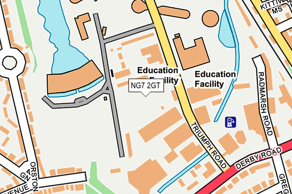
NG7 2GT is located in the Lenton & Wollaton East electoral ward, within the unitary authority of Nottingham and the English Parliamentary constituency of Nottingham South. The Sub Integrated Care Board (ICB) Location is NHS Nottingham and Nottinghamshire ICB - 52R and the police force is Nottinghamshire. This postcode has been in use since October 2009.


GetTheData
Source: OS OpenMap – Local (Ordnance Survey)
Source: OS VectorMap District (Ordnance Survey)
Licence: Open Government Licence (requires attribution)
| Easting | 454970 |
| Northing | 339445 |
| Latitude | 52.949600 |
| Longitude | -1.183314 |
GetTheData
Source: Open Postcode Geo
Licence: Open Government Licence
| Country | England |
| Postcode District | NG7 |
➜ See where NG7 is on a map ➜ Where is Nottingham? | |
GetTheData
Source: Land Registry Price Paid Data
Licence: Open Government Licence
Elevation or altitude of NG7 2GT as distance above sea level:
| Metres | Feet | |
|---|---|---|
| Elevation | 30m | 98ft |
Elevation is measured from the approximate centre of the postcode, to the nearest point on an OS contour line from OS Terrain 50, which has contour spacing of ten vertical metres.
➜ How high above sea level am I? Find the elevation of your current position using your device's GPS.
GetTheData
Source: Open Postcode Elevation
Licence: Open Government Licence
| Ward | Lenton & Wollaton East |
| Constituency | Nottingham South |
GetTheData
Source: ONS Postcode Database
Licence: Open Government Licence
| Triumph Road | Radford | 29m |
| Triumph Road | Radford | 105m |
| Triumph Road (Derby Road) | Lenton | 200m |
| Hillside (Derby Road) | Lenton | 269m |
| Hillside (Derby Road) | Lenton | 299m |
| Gregory Street Tram Stop (Lenton Lane) | Lenton | 762m |
| Queens Medical Centre Tram Stop (South Road) | Queens Medical Centre | 784m |
| University Of Nottingham Tram Stop (University Boulevard) | Nottingham University Main Campus | 1,414m |
| Ng2 Tram Stop (Enterprise Way) | Lenton Lane Industrial Estate | 1,490m |
| High School Tram Stop (Waverley Street) | Arboretum | 2,044m |
| Nottingham Station | 2.5km |
| Beeston Station | 3.6km |
| Attenborough Station | 5.8km |
GetTheData
Source: NaPTAN
Licence: Open Government Licence
GetTheData
Source: ONS Postcode Database
Licence: Open Government Licence


➜ Get more ratings from the Food Standards Agency
GetTheData
Source: Food Standards Agency
Licence: FSA terms & conditions
| Last Collection | |||
|---|---|---|---|
| Location | Mon-Fri | Sat | Distance |
| Hillside | 17:00 | 11:00 | 290m |
| Charnock Avenue | 16:30 | 12:30 | 338m |
| Faraday Road | 17:30 | 11:00 | 449m |
GetTheData
Source: Dracos
Licence: Creative Commons Attribution-ShareAlike
The below table lists the International Territorial Level (ITL) codes (formerly Nomenclature of Territorial Units for Statistics (NUTS) codes) and Local Administrative Units (LAU) codes for NG7 2GT:
| ITL 1 Code | Name |
|---|---|
| TLF | East Midlands (England) |
| ITL 2 Code | Name |
| TLF1 | Derbyshire and Nottinghamshire |
| ITL 3 Code | Name |
| TLF14 | Nottingham |
| LAU 1 Code | Name |
| E06000018 | Nottingham |
GetTheData
Source: ONS Postcode Directory
Licence: Open Government Licence
The below table lists the Census Output Area (OA), Lower Layer Super Output Area (LSOA), and Middle Layer Super Output Area (MSOA) for NG7 2GT:
| Code | Name | |
|---|---|---|
| OA | E00070531 | |
| LSOA | E01013974 | Nottingham 032B |
| MSOA | E02002899 | Nottingham 032 |
GetTheData
Source: ONS Postcode Directory
Licence: Open Government Licence
| NG7 2DZ | Derby Road | 240m |
| NG7 2DU | Faraday Road | 261m |
| NG7 2LH | Gregory Court | 273m |
| NG7 2LS | Rathmines Close | 287m |
| NG7 2DH | Kittiwake Mews | 287m |
| NG8 1AJ | Orston Drive | 304m |
| NG8 1AH | Orston Green | 313m |
| NG7 2LQ | Ingham Grove | 320m |
| NG7 2DE | Heron Drive | 336m |
| NG7 2DX | Derby Road | 344m |
GetTheData
Source: Open Postcode Geo; Land Registry Price Paid Data
Licence: Open Government Licence