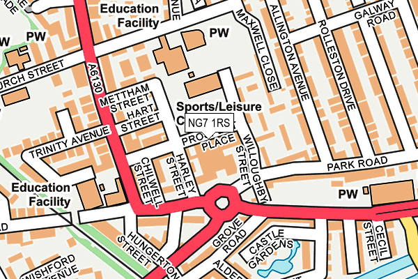
NG7 1RS is located in the Lenton & Wollaton East electoral ward, within the unitary authority of Nottingham and the English Parliamentary constituency of Nottingham South. The Sub Integrated Care Board (ICB) Location is NHS Nottingham and Nottinghamshire ICB - 52R and the police force is Nottinghamshire. This postcode has been in use since October 1984.


GetTheData
Source: OS OpenMap – Local (Ordnance Survey)
Source: OS VectorMap District (Ordnance Survey)
Licence: Open Government Licence (requires attribution)
| Easting | 455731 |
| Northing | 339247 |
| Latitude | 52.947722 |
| Longitude | -1.172027 |
GetTheData
Source: Open Postcode Geo
Licence: Open Government Licence
| Country | England |
| Postcode District | NG7 |
➜ See where NG7 is on a map ➜ Where is Nottingham? | |
GetTheData
Source: Land Registry Price Paid Data
Licence: Open Government Licence
Elevation or altitude of NG7 1RS as distance above sea level:
| Metres | Feet | |
|---|---|---|
| Elevation | 30m | 98ft |
Elevation is measured from the approximate centre of the postcode, to the nearest point on an OS contour line from OS Terrain 50, which has contour spacing of ten vertical metres.
➜ How high above sea level am I? Find the elevation of your current position using your device's GPS.
GetTheData
Source: Open Postcode Elevation
Licence: Open Government Licence
| Ward | Lenton & Wollaton East |
| Constituency | Nottingham South |
GetTheData
Source: ONS Postcode Database
Licence: Open Government Licence
| Trinity Avenue (Lenton Boulevard) | Lenton | 128m |
| Trinity Avenue (Lenton Boulevard) | Lenton | 151m |
| Alderney Street (Castle Boulevard) | Lenton | 155m |
| Church Street (Lenton Boulevard) | Lenton | 172m |
| Church Street (Lenton Boulevard) | Lenton | 172m |
| Gregory Street Tram Stop (Lenton Lane) | Lenton | 545m |
| Ng2 Tram Stop (Enterprise Way) | Lenton Lane Industrial Estate | 798m |
| Queens Medical Centre Tram Stop (South Road) | Queens Medical Centre | 975m |
| Meadows Way West Tram Stop (Meadows Way) | Meadows | 1,138m |
| Old Market Square Tram Stop (South Parade) | Nottingham | 1,548m |
| Nottingham Station | 1.7km |
| Beeston Station | 3.8km |
| Attenborough Station | 6.1km |
GetTheData
Source: NaPTAN
Licence: Open Government Licence
GetTheData
Source: ONS Postcode Database
Licence: Open Government Licence


➜ Get more ratings from the Food Standards Agency
GetTheData
Source: Food Standards Agency
Licence: FSA terms & conditions
| Last Collection | |||
|---|---|---|---|
| Location | Mon-Fri | Sat | Distance |
| Grove Road | 17:00 | 11:00 | 139m |
| New Lenton Post Office | 17:00 | 11:30 | 148m |
| Church Street/Digby Avenue | 17:30 | 11:00 | 182m |
GetTheData
Source: Dracos
Licence: Creative Commons Attribution-ShareAlike
The below table lists the International Territorial Level (ITL) codes (formerly Nomenclature of Territorial Units for Statistics (NUTS) codes) and Local Administrative Units (LAU) codes for NG7 1RS:
| ITL 1 Code | Name |
|---|---|
| TLF | East Midlands (England) |
| ITL 2 Code | Name |
| TLF1 | Derbyshire and Nottinghamshire |
| ITL 3 Code | Name |
| TLF14 | Nottingham |
| LAU 1 Code | Name |
| E06000018 | Nottingham |
GetTheData
Source: ONS Postcode Directory
Licence: Open Government Licence
The below table lists the Census Output Area (OA), Lower Layer Super Output Area (LSOA), and Middle Layer Super Output Area (MSOA) for NG7 1RS:
| Code | Name | |
|---|---|---|
| OA | E00070270 | |
| LSOA | E01033408 | Nottingham 031H |
| MSOA | E02002898 | Nottingham 031 |
GetTheData
Source: ONS Postcode Directory
Licence: Open Government Licence
| NG7 1RQ | Willoughby Street | 39m |
| NG7 1RZ | Harley Street | 41m |
| NG7 1SA | Sherwin Road | 64m |
| NG7 1SP | Willoughby Street | 67m |
| NG7 1SE | Harley Street | 72m |
| NG7 1SD | Osmaston Street | 75m |
| NG7 1SF | Hart Street | 87m |
| NG7 1SB | Chilwell Street | 87m |
| NG7 1SN | Maxwell Close | 112m |
| NG7 1SH | Mettham Street | 135m |
GetTheData
Source: Open Postcode Geo; Land Registry Price Paid Data
Licence: Open Government Licence