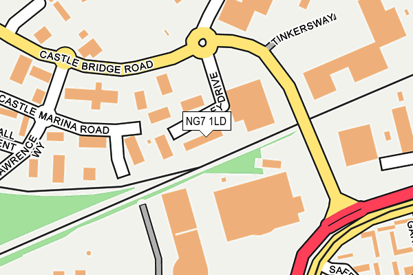
NG7 1LD is located in the Castle electoral ward, within the unitary authority of Nottingham and the English Parliamentary constituency of Nottingham South. The Sub Integrated Care Board (ICB) Location is NHS Nottingham and Nottinghamshire ICB - 52R and the police force is Nottinghamshire. This postcode has been in use since January 1992.


GetTheData
Source: OS OpenMap – Local (Ordnance Survey)
Source: OS VectorMap District (Ordnance Survey)
Licence: Open Government Licence (requires attribution)
| Easting | 456383 |
| Northing | 338842 |
| Latitude | 52.944034 |
| Longitude | -1.162392 |
GetTheData
Source: Open Postcode Geo
Licence: Open Government Licence
| Country | England |
| Postcode District | NG7 |
➜ See where NG7 is on a map ➜ Where is Nottingham? | |
GetTheData
Source: Land Registry Price Paid Data
Licence: Open Government Licence
Elevation or altitude of NG7 1LD as distance above sea level:
| Metres | Feet | |
|---|---|---|
| Elevation | 30m | 98ft |
Elevation is measured from the approximate centre of the postcode, to the nearest point on an OS contour line from OS Terrain 50, which has contour spacing of ten vertical metres.
➜ How high above sea level am I? Find the elevation of your current position using your device's GPS.
GetTheData
Source: Open Postcode Elevation
Licence: Open Government Licence
| Ward | Castle |
| Constituency | Nottingham South |
GetTheData
Source: ONS Postcode Database
Licence: Open Government Licence
| Holiday Inn (Castle Bridge Road) | Castle Marina | 139m |
| Holiday Inn (Castle Bridge Road) | Castle Marina | 156m |
| Queens Drive (Castle Bridge Road) | Queens Drive | 193m |
| Queens Drive (Castle Bridge Road) | Queens Drive | 211m |
| Ng2 Homebase (Queens Drive) | Queens Drive | 233m |
| Ng2 Tram Stop (Enterprise Way) | Lenton Lane Industrial Estate | 307m |
| Meadows Way West Tram Stop (Meadows Way) | Meadows | 390m |
| Meadows Embankment Tram Stop (Queens Walk) | Meadows | 804m |
| Queens Walk Tram Stop (Queens Walk) | Meadows | 818m |
| Gregory Street Tram Stop (Lenton Lane) | Lenton | 984m |
| Nottingham Station | 1.1km |
| Beeston Station | 4km |
| Attenborough Station | 6.3km |
GetTheData
Source: NaPTAN
Licence: Open Government Licence
Estimated total energy consumption in NG7 1LD by fuel type, 2015.
| Consumption (kWh) | 39,380 |
|---|---|
| Meter count | 6 |
| Mean (kWh/meter) | 6,563 |
| Median (kWh/meter) | 1 |
GetTheData
Source: Postcode level gas estimates: 2015 (experimental)
Source: Postcode level electricity estimates: 2015 (experimental)
Licence: Open Government Licence
GetTheData
Source: ONS Postcode Database
Licence: Open Government Licence


➜ Get more ratings from the Food Standards Agency
GetTheData
Source: Food Standards Agency
Licence: FSA terms & conditions
| Last Collection | |||
|---|---|---|---|
| Location | Mon-Fri | Sat | Distance |
| Castle Marina Business Park | 18:30 | 81m | |
| Lenton Road | 17:30 | 11:00 | 523m |
| Thrumpton Drive | 17:30 | 11:30 | 607m |
GetTheData
Source: Dracos
Licence: Creative Commons Attribution-ShareAlike
| Risk of NG7 1LD flooding from rivers and sea | Low |
| ➜ NG7 1LD flood map | |
GetTheData
Source: Open Flood Risk by Postcode
Licence: Open Government Licence
The below table lists the International Territorial Level (ITL) codes (formerly Nomenclature of Territorial Units for Statistics (NUTS) codes) and Local Administrative Units (LAU) codes for NG7 1LD:
| ITL 1 Code | Name |
|---|---|
| TLF | East Midlands (England) |
| ITL 2 Code | Name |
| TLF1 | Derbyshire and Nottinghamshire |
| ITL 3 Code | Name |
| TLF14 | Nottingham |
| LAU 1 Code | Name |
| E06000018 | Nottingham |
GetTheData
Source: ONS Postcode Directory
Licence: Open Government Licence
The below table lists the Census Output Area (OA), Lower Layer Super Output Area (LSOA), and Middle Layer Super Output Area (MSOA) for NG7 1LD:
| Code | Name | |
|---|---|---|
| OA | E00069992 | |
| LSOA | E01013870 | Nottingham 040A |
| MSOA | E02006905 | Nottingham 040 |
GetTheData
Source: ONS Postcode Directory
Licence: Open Government Licence
| NG7 1GJ | Flamingo Court | 274m |
| NG7 1HT | The Quays | 276m |
| NG7 1TL | Plover Wharf | 295m |
| NG2 1QE | Phoenix Close | 318m |
| NG7 1HR | The Quays | 324m |
| NG2 1PW | Crammond Close | 329m |
| NG2 1QF | Saffron Gardens | 329m |
| NG7 1TJ | Dunlin Wharf | 336m |
| NG7 1GW | Teal Wharf | 339m |
| NG7 1SL | Church Square | 351m |
GetTheData
Source: Open Postcode Geo; Land Registry Price Paid Data
Licence: Open Government Licence