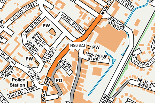
NG6 8ZJ is located in the Bulwell electoral ward, within the unitary authority of Nottingham and the English Parliamentary constituency of Nottingham North. The Sub Integrated Care Board (ICB) Location is NHS Nottingham and Nottinghamshire ICB - 52R and the police force is Nottinghamshire. This postcode has been in use since June 2018.


GetTheData
Source: OS OpenMap – Local (Ordnance Survey)
Source: OS VectorMap District (Ordnance Survey)
Licence: Open Government Licence (requires attribution)
| Easting | 454038 |
| Northing | 345334 |
| Latitude | 53.002626 |
| Longitude | -1.196203 |
GetTheData
Source: Open Postcode Geo
Licence: Open Government Licence
| Country | England |
| Postcode District | NG6 |
➜ See where NG6 is on a map ➜ Where is Nottingham? | |
GetTheData
Source: Land Registry Price Paid Data
Licence: Open Government Licence
| Ward | Bulwell |
| Constituency | Nottingham North |
GetTheData
Source: ONS Postcode Database
Licence: Open Government Licence
| Duke Street (Bulwell High Road) | Bulwell | 60m |
| Duke Street (Bulwell High Road) | Bulwell | 75m |
| Duke Street (Bulwell High Road) | Bulwell | 89m |
| Merchant Street (Main Street) | Bulwell | 105m |
| Merchant Street (Main Street) | Bulwell | 139m |
| Bulwell Tram Stop (Station Road) | Bulwell | 334m |
| Bulwell Forest Tram Stop (Bestwood Road) | Bulwell Forest | 488m |
| Moor Bridge Tram Stop (Hucknall Lane) | Moor Bridge | 1,457m |
| Highbury Vale Tram Stop (Highbury Vale) | Highbury Vale | 1,496m |
| Bulwell Station | 0.3km |
| Hucknall Station | 4km |
GetTheData
Source: NaPTAN
Licence: Open Government Licence
| Percentage of properties with Next Generation Access | 100.0% |
| Percentage of properties with Superfast Broadband | 100.0% |
| Percentage of properties with Ultrafast Broadband | 100.0% |
| Percentage of properties with Full Fibre Broadband | 0.0% |
Superfast Broadband is between 30Mbps and 300Mbps
Ultrafast Broadband is > 300Mbps
| Percentage of properties unable to receive 2Mbps | 0.0% |
| Percentage of properties unable to receive 5Mbps | 0.0% |
| Percentage of properties unable to receive 10Mbps | 0.0% |
| Percentage of properties unable to receive 30Mbps | 0.0% |
GetTheData
Source: Ofcom
Licence: Ofcom Terms of Use (requires attribution)
GetTheData
Source: ONS Postcode Database
Licence: Open Government Licence


➜ Get more ratings from the Food Standards Agency
GetTheData
Source: Food Standards Agency
Licence: FSA terms & conditions
| Last Collection | |||
|---|---|---|---|
| Location | Mon-Fri | Sat | Distance |
| Bulwell Post Office | 17:15 | 12:00 | 157m |
| Ravensworth Road | 17:30 | 12:00 | 433m |
| Cantrell Road | 17:30 | 12:00 | 442m |
GetTheData
Source: Dracos
Licence: Creative Commons Attribution-ShareAlike
The below table lists the International Territorial Level (ITL) codes (formerly Nomenclature of Territorial Units for Statistics (NUTS) codes) and Local Administrative Units (LAU) codes for NG6 8ZJ:
| ITL 1 Code | Name |
|---|---|
| TLF | East Midlands (England) |
| ITL 2 Code | Name |
| TLF1 | Derbyshire and Nottinghamshire |
| ITL 3 Code | Name |
| TLF14 | Nottingham |
| LAU 1 Code | Name |
| E06000018 | Nottingham |
GetTheData
Source: ONS Postcode Directory
Licence: Open Government Licence
The below table lists the Census Output Area (OA), Lower Layer Super Output Area (LSOA), and Middle Layer Super Output Area (MSOA) for NG6 8ZJ:
| Code | Name | |
|---|---|---|
| OA | E00070029 | |
| LSOA | E01013885 | Nottingham 002E |
| MSOA | E02002869 | Nottingham 002 |
GetTheData
Source: ONS Postcode Directory
Licence: Open Government Licence
| NG6 8EZ | Main Street | 59m |
| NG6 8FL | Robinsons Hill | 68m |
| NG6 8ET | Main Street | 71m |
| NG6 8FQ | Stockton Street | 76m |
| NG6 8EU | Montague Street | 90m |
| NG6 8FR | Strelley Street | 107m |
| NG6 8ED | Main Street | 109m |
| NG6 8EA | Hazel Street | 119m |
| NG6 8FN | Ravensworth Road | 125m |
| NG6 8HA | Commercial Road | 145m |
GetTheData
Source: Open Postcode Geo; Land Registry Price Paid Data
Licence: Open Government Licence
| Main Street | At Any Time | 11m |
| Pilkington Street | At Any Time | 198m |
| Main Street | At Any Time | 268m |
GetTheData
Source: Disabled parking spaces, Nottingham City Council, 19/02/2013
Licence: Open Government Licence