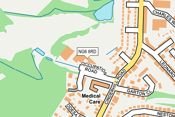
NG6 8RD is located in the Bulwell electoral ward, within the unitary authority of Nottingham and the English Parliamentary constituency of Nottingham North. The Sub Integrated Care Board (ICB) Location is NHS Nottingham and Nottinghamshire ICB - 52R and the police force is Nottinghamshire. This postcode has been in use since January 1980.


GetTheData
Source: OS OpenMap – Local (Ordnance Survey)
Source: OS VectorMap District (Ordnance Survey)
Licence: Open Government Licence (requires attribution)
| Easting | 453753 |
| Northing | 344147 |
| Latitude | 52.991985 |
| Longitude | -1.200647 |
GetTheData
Source: Open Postcode Geo
Licence: Open Government Licence
| Country | England |
| Postcode District | NG6 |
➜ See where NG6 is on a map ➜ Where is Nottingham? | |
GetTheData
Source: Land Registry Price Paid Data
Licence: Open Government Licence
Elevation or altitude of NG6 8RD as distance above sea level:
| Metres | Feet | |
|---|---|---|
| Elevation | 50m | 164ft |
Elevation is measured from the approximate centre of the postcode, to the nearest point on an OS contour line from OS Terrain 50, which has contour spacing of ten vertical metres.
➜ How high above sea level am I? Find the elevation of your current position using your device's GPS.
GetTheData
Source: Open Postcode Elevation
Licence: Open Government Licence
| Ward | Bulwell |
| Constituency | Nottingham North |
GetTheData
Source: ONS Postcode Database
Licence: Open Government Licence
| Leonard Street (Cinderhill Road) | Hempshill Vale | 177m |
| Headstocks (Cinderhill Road) | Cinderhill | 201m |
| Leonard Street (Cinderhill Road) | Hempshill Vale | 218m |
| Headstocks (Cinderhill Road) | Cinderhill | 262m |
| Glenn's (Cinderhill Road) | Hempshill Vale | 299m |
| Cinderhill Tram Stop (Cinderhill Road) | Cinderhill | 332m |
| Phoenix Park Tram Stop (Millennium Way East) | Phoenix Park | 543m |
| Highbury Vale Tram Stop (Highbury Vale) | Highbury Vale | 760m |
| Bulwell Tram Stop (Station Road) | Bulwell | 932m |
| David Lane Tram Stop (Vernon Road) | Basford | 1,471m |
| Bulwell Station | 0.9km |
| Nottingham Station | 6.2km |
GetTheData
Source: NaPTAN
Licence: Open Government Licence
GetTheData
Source: ONS Postcode Database
Licence: Open Government Licence


➜ Get more ratings from the Food Standards Agency
GetTheData
Source: Food Standards Agency
Licence: FSA terms & conditions
| Last Collection | |||
|---|---|---|---|
| Location | Mon-Fri | Sat | Distance |
| Leonard Street | 17:30 | 11:30 | 131m |
| Neston Drive | 17:30 | 11:30 | 309m |
| Northall Avenue | 17:30 | 09:30 | 428m |
GetTheData
Source: Dracos
Licence: Creative Commons Attribution-ShareAlike
The below table lists the International Territorial Level (ITL) codes (formerly Nomenclature of Territorial Units for Statistics (NUTS) codes) and Local Administrative Units (LAU) codes for NG6 8RD:
| ITL 1 Code | Name |
|---|---|
| TLF | East Midlands (England) |
| ITL 2 Code | Name |
| TLF1 | Derbyshire and Nottinghamshire |
| ITL 3 Code | Name |
| TLF14 | Nottingham |
| LAU 1 Code | Name |
| E06000018 | Nottingham |
GetTheData
Source: ONS Postcode Directory
Licence: Open Government Licence
The below table lists the Census Output Area (OA), Lower Layer Super Output Area (LSOA), and Middle Layer Super Output Area (MSOA) for NG6 8RD:
| Code | Name | |
|---|---|---|
| OA | E00070050 | |
| LSOA | E01013876 | Nottingham 005B |
| MSOA | E02002872 | Nottingham 005 |
GetTheData
Source: ONS Postcode Directory
Licence: Open Government Licence
| NG6 8RP | Anford Close | 107m |
| NG6 8RB | Paddock Close | 123m |
| NG6 8SD | Cinderhill Road | 138m |
| NG6 8RN | Dursley Close | 151m |
| NG6 8RL | Cinderhill Road | 169m |
| NG6 8RQ | Cinderhill Road | 171m |
| NG6 8RZ | Garton Close | 200m |
| NG6 8SE | Cinderhill Road | 207m |
| NG6 8SB | Cinderhill Road | 232m |
| NG6 8QR | Donbas Close | 233m |
GetTheData
Source: Open Postcode Geo; Land Registry Price Paid Data
Licence: Open Government Licence