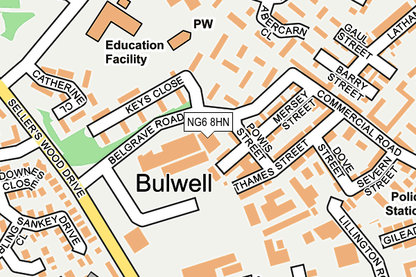
NG6 8HN is located in the Bulwell electoral ward, within the unitary authority of Nottingham and the English Parliamentary constituency of Nottingham North. The Sub Integrated Care Board (ICB) Location is NHS Nottingham and Nottinghamshire ICB - 52R and the police force is Nottinghamshire. This postcode has been in use since January 1980.


GetTheData
Source: OS OpenMap – Local (Ordnance Survey)
Source: OS VectorMap District (Ordnance Survey)
Licence: Open Government Licence (requires attribution)
| Easting | 453489 |
| Northing | 345273 |
| Latitude | 53.002132 |
| Longitude | -1.204393 |
GetTheData
Source: Open Postcode Geo
Licence: Open Government Licence
| Country | England |
| Postcode District | NG6 |
➜ See where NG6 is on a map ➜ Where is Nottingham? | |
GetTheData
Source: Land Registry Price Paid Data
Licence: Open Government Licence
Elevation or altitude of NG6 8HN as distance above sea level:
| Metres | Feet | |
|---|---|---|
| Elevation | 50m | 164ft |
Elevation is measured from the approximate centre of the postcode, to the nearest point on an OS contour line from OS Terrain 50, which has contour spacing of ten vertical metres.
➜ How high above sea level am I? Find the elevation of your current position using your device's GPS.
GetTheData
Source: Open Postcode Elevation
Licence: Open Government Licence
| Ward | Bulwell |
| Constituency | Nottingham North |
GetTheData
Source: ONS Postcode Database
Licence: Open Government Licence
| Sellers Wood Drive H&r (Sellers Wood Drive) | Snape Wood | 215m |
| Catherine Close (Hoewood Road) | Bulwell | 265m |
| Catherine Close (Hoewood Road) | Bulwell | 272m |
| Rock Street Od (Rock Street) | Bulwell | 334m |
| Bardney Drive (Hoewood Road) | Bulwell | 387m |
| Bulwell Tram Stop (Station Road) | Bulwell | 675m |
| Bulwell Forest Tram Stop (Bestwood Road) | Bulwell Forest | 992m |
| Phoenix Park Tram Stop (Millennium Way East) | Phoenix Park | 1,472m |
| Cinderhill Tram Stop (Cinderhill Road) | Cinderhill | 1,482m |
| Highbury Vale Tram Stop (Highbury Vale) | Highbury Vale | 1,687m |
| Bulwell Station | 0.6km |
| Hucknall Station | 4.1km |
GetTheData
Source: NaPTAN
Licence: Open Government Licence
GetTheData
Source: ONS Postcode Database
Licence: Open Government Licence


➜ Get more ratings from the Food Standards Agency
GetTheData
Source: Food Standards Agency
Licence: FSA terms & conditions
| Last Collection | |||
|---|---|---|---|
| Location | Mon-Fri | Sat | Distance |
| Dogwood Avenue | 17:30 | 11:30 | 390m |
| Crabtree Road | 17:30 | 11:30 | 437m |
| Bulwell Post Office | 17:15 | 12:00 | 550m |
GetTheData
Source: Dracos
Licence: Creative Commons Attribution-ShareAlike
The below table lists the International Territorial Level (ITL) codes (formerly Nomenclature of Territorial Units for Statistics (NUTS) codes) and Local Administrative Units (LAU) codes for NG6 8HN:
| ITL 1 Code | Name |
|---|---|
| TLF | East Midlands (England) |
| ITL 2 Code | Name |
| TLF1 | Derbyshire and Nottinghamshire |
| ITL 3 Code | Name |
| TLF14 | Nottingham |
| LAU 1 Code | Name |
| E06000018 | Nottingham |
GetTheData
Source: ONS Postcode Directory
Licence: Open Government Licence
The below table lists the Census Output Area (OA), Lower Layer Super Output Area (LSOA), and Middle Layer Super Output Area (MSOA) for NG6 8HN:
| Code | Name | |
|---|---|---|
| OA | E00070033 | |
| LSOA | E01013885 | Nottingham 002E |
| MSOA | E02002869 | Nottingham 002 |
GetTheData
Source: ONS Postcode Directory
Licence: Open Government Licence
| NG6 8HZ | Powis Street | 77m |
| NG6 8JL | Keys Close | 93m |
| NG6 8JA | Mersey Street | 127m |
| NG6 8JG | Musters Walk | 137m |
| NG6 8JF | Bethnal Walk | 152m |
| NG6 8HW | Thames Street | 172m |
| NG6 8TZ | Rufford Walk | 179m |
| NG6 8JB | Commercial Road | 192m |
| NG6 8JP | Catherine Close | 200m |
| NG6 8LR | Dove Street | 205m |
GetTheData
Source: Open Postcode Geo; Land Registry Price Paid Data
Licence: Open Government Licence
| Pilkington Street | At Any Time | 469m |
GetTheData
Source: Disabled parking spaces, Nottingham City Council, 19/02/2013
Licence: Open Government Licence