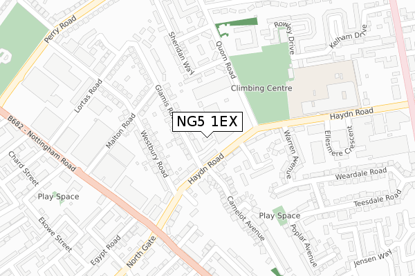
NG5 1EX is located in the Berridge electoral ward, within the unitary authority of Nottingham and the English Parliamentary constituency of Nottingham East. The Sub Integrated Care Board (ICB) Location is NHS Nottingham and Nottinghamshire ICB - 52R and the police force is Nottinghamshire. This postcode has been in use since October 2019.


GetTheData
Source: OS Open Zoomstack (Ordnance Survey)
Licence: Open Government Licence (requires attribution)
Attribution: Contains OS data © Crown copyright and database right 2025
Source: Open Postcode Geo
Licence: Open Government Licence (requires attribution)
Attribution: Contains OS data © Crown copyright and database right 2025; Contains Royal Mail data © Royal Mail copyright and database right 2025; Source: Office for National Statistics licensed under the Open Government Licence v.3.0
| Easting | 456199 |
| Northing | 342712 |
| Latitude | 52.978837 |
| Longitude | -1.164459 |
GetTheData
Source: Open Postcode Geo
Licence: Open Government Licence
| Country | England |
| Postcode District | NG5 |
➜ See where NG5 is on a map ➜ Where is Nottingham? | |
GetTheData
Source: Land Registry Price Paid Data
Licence: Open Government Licence
| Ward | Berridge |
| Constituency | Nottingham East |
GetTheData
Source: ONS Postcode Database
Licence: Open Government Licence
| Haydn Road (Nottingham Road) | Basford | 261m |
| Haydn Road (Nottingham Road) | Sherwood Rise | 293m |
| Zulu Road (Nottingham Road) | Basford | 320m |
| Monsall Street (North Gate) | Basford | 334m |
| Zulu Road (Nottingham Road) | Basford | 363m |
| Basford Tram Stop (Vernon Road) | Basford | 999m |
| Shipstone Street Tram Stop (Shipstone Street) | Radford | 1,010m |
| Beaconsfield Street Tram Stop (Noel Street) | Forest Fields | 1,045m |
| Wilkinson Street Tram Stop (Wilkinson Street) | Basford | 1,189m |
| Radford Road Tram Stop (Radford Road) | Forest Fields | 1,201m |
| Bulwell Station | 3.2km |
| Nottingham Station | 3.7km |
GetTheData
Source: NaPTAN
Licence: Open Government Licence
GetTheData
Source: ONS Postcode Database
Licence: Open Government Licence


➜ Get more ratings from the Food Standards Agency
GetTheData
Source: Food Standards Agency
Licence: FSA terms & conditions
| Last Collection | |||
|---|---|---|---|
| Location | Mon-Fri | Sat | Distance |
| Westbury Road | 17:30 | 10:30 | 175m |
| Egypt Road | 17:30 | 12:30 | 261m |
| Perry Road | 17:30 | 10:30 | 448m |
GetTheData
Source: Dracos
Licence: Creative Commons Attribution-ShareAlike
The below table lists the International Territorial Level (ITL) codes (formerly Nomenclature of Territorial Units for Statistics (NUTS) codes) and Local Administrative Units (LAU) codes for NG5 1EX:
| ITL 1 Code | Name |
|---|---|
| TLF | East Midlands (England) |
| ITL 2 Code | Name |
| TLF1 | Derbyshire and Nottinghamshire |
| ITL 3 Code | Name |
| TLF14 | Nottingham |
| LAU 1 Code | Name |
| E06000018 | Nottingham |
GetTheData
Source: ONS Postcode Directory
Licence: Open Government Licence
The below table lists the Census Output Area (OA), Lower Layer Super Output Area (LSOA), and Middle Layer Super Output Area (MSOA) for NG5 1EX:
| Code | Name | |
|---|---|---|
| OA | E00069839 | |
| LSOA | E01013838 | Nottingham 012B |
| MSOA | E02002879 | Nottingham 012 |
GetTheData
Source: ONS Postcode Directory
Licence: Open Government Licence
| NG5 1EA | Haydn Road | 82m |
| NG5 1DU | Moores Place | 102m |
| NG5 1DZ | Haydn Road | 120m |
| NG5 1DY | Langdon Close | 121m |
| NG5 1ED | Glamis Road | 131m |
| NG5 1EF | Glamis Road | 148m |
| NG5 1EP | Westbury Road | 150m |
| NG5 1DP | Linette Close | 190m |
| NG5 1EG | Malton Road | 196m |
| NG5 1DE | Warren Avenue | 198m |
GetTheData
Source: Open Postcode Geo; Land Registry Price Paid Data
Licence: Open Government Licence