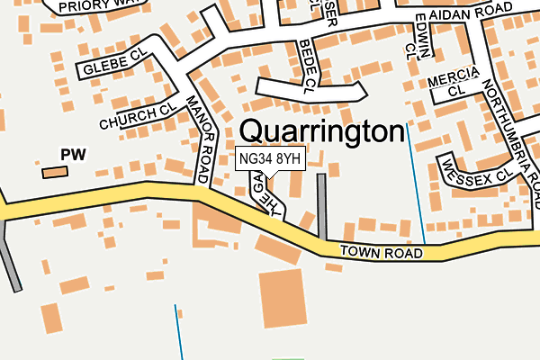
NG34 8YH is located in the Sleaford Holdingham electoral ward, within the local authority district of North Kesteven and the English Parliamentary constituency of Sleaford and North Hykeham. The Sub Integrated Care Board (ICB) Location is NHS Lincolnshire ICB - 71E and the police force is Lincolnshire. This postcode has been in use since October 2015.


GetTheData
Source: OS OpenMap – Local (Ordnance Survey)
Source: OS VectorMap District (Ordnance Survey)
Licence: Open Government Licence (requires attribution)
| Easting | 506866 |
| Northing | 347731 |
| Latitude | 53.016245 |
| Longitude | -0.408446 |
GetTheData
Source: Open Postcode Geo
Licence: Open Government Licence
| Country | England |
| Postcode District | NG34 |
➜ See where NG34 is on a map | |
GetTheData
Source: Land Registry Price Paid Data
Licence: Open Government Licence
Elevation or altitude of NG34 8YH as distance above sea level:
| Metres | Feet | |
|---|---|---|
| Elevation | 20m | 66ft |
Elevation is measured from the approximate centre of the postcode, to the nearest point on an OS contour line from OS Terrain 50, which has contour spacing of ten vertical metres.
➜ How high above sea level am I? Find the elevation of your current position using your device's GPS.
GetTheData
Source: Open Postcode Elevation
Licence: Open Government Licence
| Ward | Sleaford Holdingham |
| Constituency | Sleaford And North Hykeham |
GetTheData
Source: ONS Postcode Database
Licence: Open Government Licence
| Summerfield Drive (Woodside Avenue) | Sleaford | 729m |
| Birchwood Road (Woodside Avenue) | Sleaford | 808m |
| Ripon Drive (Almond Walk) | Sleaford | 857m |
| Hazel Grove (Almond Walk) | Sleaford | 951m |
| Exeter Drive (York Road) | Sleaford | 973m |
| Sleaford Station | 2.3km |
| Ruskington Station | 3.4km |
| Rauceby Station | 4.7km |
GetTheData
Source: NaPTAN
Licence: Open Government Licence
GetTheData
Source: ONS Postcode Database
Licence: Open Government Licence

➜ Get more ratings from the Food Standards Agency
GetTheData
Source: Food Standards Agency
Licence: FSA terms & conditions
| Last Collection | |||
|---|---|---|---|
| Location | Mon-Fri | Sat | Distance |
| Licoln Road Post Office | 17:00 | 11:30 | 1,152m |
| Tennyson Avenue | 17:45 | 11:15 | 1,452m |
| East Road Ind Est | 18:30 | 10:30 | 1,502m |
GetTheData
Source: Dracos
Licence: Creative Commons Attribution-ShareAlike
The below table lists the International Territorial Level (ITL) codes (formerly Nomenclature of Territorial Units for Statistics (NUTS) codes) and Local Administrative Units (LAU) codes for NG34 8YH:
| ITL 1 Code | Name |
|---|---|
| TLF | East Midlands (England) |
| ITL 2 Code | Name |
| TLF3 | Lincolnshire |
| ITL 3 Code | Name |
| TLF30 | Lincolnshire CC |
| LAU 1 Code | Name |
| E07000139 | North Kesteven |
GetTheData
Source: ONS Postcode Directory
Licence: Open Government Licence
The below table lists the Census Output Area (OA), Lower Layer Super Output Area (LSOA), and Middle Layer Super Output Area (MSOA) for NG34 8YH:
| Code | Name | |
|---|---|---|
| OA | E00133200 | |
| LSOA | E01026230 | North Kesteven 010B |
| MSOA | E02005462 | North Kesteven 010 |
GetTheData
Source: ONS Postcode Directory
Licence: Open Government Licence
| NG34 8JG | Greenfield Road | 640m |
| NG34 8TZ | Woodside Court | 655m |
| NG34 8UQ | Greenfield Road | 702m |
| NG34 8WL | Taunton Close | 714m |
| NG34 8WW | Oxford Court | 729m |
| NG34 8UH | Woodside Avenue | 749m |
| NG34 8TU | Summerfield Court | 793m |
| NG34 8TY | Ashby Court | 797m |
| NG34 8WH | Winchester Way | 800m |
| NG34 8WG | Winchester Way | 808m |
GetTheData
Source: Open Postcode Geo; Land Registry Price Paid Data
Licence: Open Government Licence