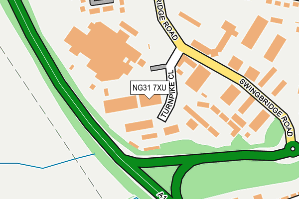
NG31 7XU is located in the Grantham Earlesfield electoral ward, within the local authority district of South Kesteven and the English Parliamentary constituency of Grantham and Stamford. The Sub Integrated Care Board (ICB) Location is NHS Lincolnshire ICB - 71E and the police force is Lincolnshire. This postcode has been in use since October 1987.


GetTheData
Source: OS OpenMap – Local (Ordnance Survey)
Source: OS VectorMap District (Ordnance Survey)
Licence: Open Government Licence (requires attribution)
| Easting | 489821 |
| Northing | 334410 |
| Latitude | 52.899659 |
| Longitude | -0.666134 |
GetTheData
Source: Open Postcode Geo
Licence: Open Government Licence
| Country | England |
| Postcode District | NG31 |
➜ See where NG31 is on a map ➜ Where is Grantham? | |
GetTheData
Source: Land Registry Price Paid Data
Licence: Open Government Licence
Elevation or altitude of NG31 7XU as distance above sea level:
| Metres | Feet | |
|---|---|---|
| Elevation | 70m | 230ft |
Elevation is measured from the approximate centre of the postcode, to the nearest point on an OS contour line from OS Terrain 50, which has contour spacing of ten vertical metres.
➜ How high above sea level am I? Find the elevation of your current position using your device's GPS.
GetTheData
Source: Open Postcode Elevation
Licence: Open Government Licence
| Ward | Grantham Earlesfield |
| Constituency | Grantham And Stamford |
GetTheData
Source: ONS Postcode Database
Licence: Open Government Licence
| Turnpike Close (Swingbridge Road) | Grantham | 180m |
| Turnpike Close (Swingbridge Road) | Grantham | 181m |
| Ramada Hotel (Swingbridge Road) | Grantham | 232m |
| Ramada Hotel (Swingbridge Road) | Grantham | 274m |
| Squash Centre (Harlaxton Road) | Grantham | 275m |
| Grantham Station | 1.8km |
GetTheData
Source: NaPTAN
Licence: Open Government Licence
Estimated total energy consumption in NG31 7XU by fuel type, 2015.
| Consumption (kWh) | 157,769 |
|---|---|
| Meter count | 16 |
| Mean (kWh/meter) | 9,861 |
| Median (kWh/meter) | 5,036 |
GetTheData
Source: Postcode level gas estimates: 2015 (experimental)
Source: Postcode level electricity estimates: 2015 (experimental)
Licence: Open Government Licence
GetTheData
Source: ONS Postcode Database
Licence: Open Government Licence


➜ Get more ratings from the Food Standards Agency
GetTheData
Source: Food Standards Agency
Licence: FSA terms & conditions
| Last Collection | |||
|---|---|---|---|
| Location | Mon-Fri | Sat | Distance |
| Ellesmere Business Park | 18:30 | 11:45 | 211m |
| Kittybriggs Lane | 17:00 | 11:45 | 563m |
| Dysart Road Post Office | 17:00 | 12:00 | 1,242m |
GetTheData
Source: Dracos
Licence: Creative Commons Attribution-ShareAlike
The below table lists the International Territorial Level (ITL) codes (formerly Nomenclature of Territorial Units for Statistics (NUTS) codes) and Local Administrative Units (LAU) codes for NG31 7XU:
| ITL 1 Code | Name |
|---|---|
| TLF | East Midlands (England) |
| ITL 2 Code | Name |
| TLF3 | Lincolnshire |
| ITL 3 Code | Name |
| TLF30 | Lincolnshire CC |
| LAU 1 Code | Name |
| E07000141 | South Kesteven |
GetTheData
Source: ONS Postcode Directory
Licence: Open Government Licence
The below table lists the Census Output Area (OA), Lower Layer Super Output Area (LSOA), and Middle Layer Super Output Area (MSOA) for NG31 7XU:
| Code | Name | |
|---|---|---|
| OA | E00133635 | |
| LSOA | E01026308 | South Kesteven 005A |
| MSOA | E02005480 | South Kesteven 005 |
GetTheData
Source: ONS Postcode Directory
Licence: Open Government Licence
| NG31 7XT | Swingbridge Road | 298m |
| NG31 7XN | Shaw Road | 318m |
| NG31 7JX | Harlaxton Road | 319m |
| NG31 7XJ | Hawthorne Court | 342m |
| NG31 7XL | Larch Close | 345m |
| NG31 7JT | Harlaxton Road | 397m |
| NG31 7XW | Sycamore Court | 402m |
| NG31 7XP | Kinoulton Court | 404m |
| NG31 7JU | Welwyn Close | 417m |
| NG31 7XD | Hornsby Road | 430m |
GetTheData
Source: Open Postcode Geo; Land Registry Price Paid Data
Licence: Open Government Licence