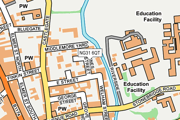
NG31 6QT lies on Riverside in Grantham. NG31 6QT is located in the Grantham St Wulfram's electoral ward, within the local authority district of South Kesteven and the English Parliamentary constituency of Grantham and Stamford. The Sub Integrated Care Board (ICB) Location is NHS Lincolnshire ICB - 71E and the police force is Lincolnshire. This postcode has been in use since January 1980.


GetTheData
Source: OS OpenMap – Local (Ordnance Survey)
Source: OS VectorMap District (Ordnance Survey)
Licence: Open Government Licence (requires attribution)
| Easting | 491677 |
| Northing | 335924 |
| Latitude | 52.912930 |
| Longitude | -0.638129 |
GetTheData
Source: Open Postcode Geo
Licence: Open Government Licence
| Street | Riverside |
| Town/City | Grantham |
| Country | England |
| Postcode District | NG31 |
➜ See where NG31 is on a map ➜ Where is Grantham? | |
GetTheData
Source: Land Registry Price Paid Data
Licence: Open Government Licence
Elevation or altitude of NG31 6QT as distance above sea level:
| Metres | Feet | |
|---|---|---|
| Elevation | 60m | 197ft |
Elevation is measured from the approximate centre of the postcode, to the nearest point on an OS contour line from OS Terrain 50, which has contour spacing of ten vertical metres.
➜ How high above sea level am I? Find the elevation of your current position using your device's GPS.
GetTheData
Source: Open Postcode Elevation
Licence: Open Government Licence
| Ward | Grantham St Wulfram's |
| Constituency | Grantham And Stamford |
GetTheData
Source: ONS Postcode Database
Licence: Open Government Licence
| National Junior School (Castlegate) | Grantham | 205m |
| Police Station (Stonebridge Road) | Grantham | 233m |
| Castlegate (Avenue Road) | Grantham | 253m |
| Reel Cinema (St Catherine's Road) | Grantham | 288m |
| Finkin Street (High Street) | Grantham | 296m |
| Grantham Station | 0.8km |
GetTheData
Source: NaPTAN
Licence: Open Government Licence
| Median download speed | 19.0Mbps |
| Average download speed | 39.4Mbps |
| Maximum download speed | 200.00Mbps |
| Median upload speed | 1.1Mbps |
| Average upload speed | 1.0Mbps |
| Maximum upload speed | 1.24Mbps |
GetTheData
Source: Ofcom
Licence: Ofcom Terms of Use (requires attribution)
Estimated total energy consumption in NG31 6QT by fuel type, 2015.
| Consumption (kWh) | 53,547 |
|---|---|
| Meter count | 41 |
| Mean (kWh/meter) | 1,306 |
| Median (kWh/meter) | 1,278 |
GetTheData
Source: Postcode level gas estimates: 2015 (experimental)
Source: Postcode level electricity estimates: 2015 (experimental)
Licence: Open Government Licence
GetTheData
Source: ONS Postcode Database
Licence: Open Government Licence


➜ Get more ratings from the Food Standards Agency
GetTheData
Source: Food Standards Agency
Licence: FSA terms & conditions
| Last Collection | |||
|---|---|---|---|
| Location | Mon-Fri | Sat | Distance |
| High Street | 19:00 | 12:00 | 301m |
| St Catherines Road | 18:15 | 11:30 | 305m |
| Westgate | 17:15 | 12:00 | 380m |
GetTheData
Source: Dracos
Licence: Creative Commons Attribution-ShareAlike
| Risk of NG31 6QT flooding from rivers and sea | Low |
| ➜ NG31 6QT flood map | |
GetTheData
Source: Open Flood Risk by Postcode
Licence: Open Government Licence
The below table lists the International Territorial Level (ITL) codes (formerly Nomenclature of Territorial Units for Statistics (NUTS) codes) and Local Administrative Units (LAU) codes for NG31 6QT:
| ITL 1 Code | Name |
|---|---|
| TLF | East Midlands (England) |
| ITL 2 Code | Name |
| TLF3 | Lincolnshire |
| ITL 3 Code | Name |
| TLF30 | Lincolnshire CC |
| LAU 1 Code | Name |
| E07000141 | South Kesteven |
GetTheData
Source: ONS Postcode Directory
Licence: Open Government Licence
The below table lists the Census Output Area (OA), Lower Layer Super Output Area (LSOA), and Middle Layer Super Output Area (MSOA) for NG31 6QT:
| Code | Name | |
|---|---|---|
| OA | E00133697 | |
| LSOA | E01026323 | South Kesteven 004D |
| MSOA | E02005479 | South Kesteven 004 |
GetTheData
Source: ONS Postcode Directory
Licence: Open Government Licence
| NG31 6QW | East Street | 106m |
| NG31 6TB | Castlegate | 108m |
| NG31 6QU | Welham Street | 110m |
| NG31 6QL | George Street | 125m |
| NG31 6SN | Castlegate | 141m |
| NG31 6TF | Avenue Road | 159m |
| NG31 6TA | Avenue Road | 164m |
| NG31 6SW | Castlegate | 168m |
| NG31 6SE | Castlegate | 181m |
| NG31 6TH | Avenue Road | 189m |
GetTheData
Source: Open Postcode Geo; Land Registry Price Paid Data
Licence: Open Government Licence