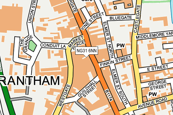
NG31 6NN lies on High Street in Grantham. NG31 6NN is located in the Grantham St Wulfram's electoral ward, within the local authority district of South Kesteven and the English Parliamentary constituency of Grantham and Stamford. The Sub Integrated Care Board (ICB) Location is NHS Lincolnshire ICB - 71E and the police force is Lincolnshire. This postcode has been in use since January 1980.


GetTheData
Source: OS OpenMap – Local (Ordnance Survey)
Source: OS VectorMap District (Ordnance Survey)
Licence: Open Government Licence (requires attribution)
| Easting | 491355 |
| Northing | 335889 |
| Latitude | 52.912670 |
| Longitude | -0.642926 |
GetTheData
Source: Open Postcode Geo
Licence: Open Government Licence
| Street | High Street |
| Town/City | Grantham |
| Country | England |
| Postcode District | NG31 |
➜ See where NG31 is on a map ➜ Where is Grantham? | |
GetTheData
Source: Land Registry Price Paid Data
Licence: Open Government Licence
Elevation or altitude of NG31 6NN as distance above sea level:
| Metres | Feet | |
|---|---|---|
| Elevation | 60m | 197ft |
Elevation is measured from the approximate centre of the postcode, to the nearest point on an OS contour line from OS Terrain 50, which has contour spacing of ten vertical metres.
➜ How high above sea level am I? Find the elevation of your current position using your device's GPS.
GetTheData
Source: Open Postcode Elevation
Licence: Open Government Licence
| Ward | Grantham St Wulfram's |
| Constituency | Grantham And Stamford |
GetTheData
Source: ONS Postcode Database
Licence: Open Government Licence
64, HIGH STREET, GRANTHAM, NG31 6NN 2005 1 FEB £222,500 |
67, HIGH STREET, GRANTHAM, NG31 6NN 2003 4 MAR £160,000 |
67, HIGH STREET, GRANTHAM, NG31 6NN 1999 16 AUG £150,000 |
GetTheData
Source: HM Land Registry Price Paid Data
Licence: Contains HM Land Registry data © Crown copyright and database right 2025. This data is licensed under the Open Government Licence v3.0.
| Finkin Street (High Street) | Grantham | 28m |
| Vine Street (Watergate) | Grantham | 156m |
| Boots (St Peter's Hill) | Grantham | 186m |
| Castlegate (Avenue Road) | Grantham | 236m |
| National Junior School (Castlegate) | Grantham | 267m |
| Grantham Station | 0.7km |
GetTheData
Source: NaPTAN
Licence: Open Government Licence
GetTheData
Source: ONS Postcode Database
Licence: Open Government Licence


➜ Get more ratings from the Food Standards Agency
GetTheData
Source: Food Standards Agency
Licence: FSA terms & conditions
| Last Collection | |||
|---|---|---|---|
| Location | Mon-Fri | Sat | Distance |
| High Street | 19:00 | 12:00 | 26m |
| Westgate | 17:15 | 12:00 | 67m |
| Morrisons | 17:15 | 11:30 | 264m |
GetTheData
Source: Dracos
Licence: Creative Commons Attribution-ShareAlike
The below table lists the International Territorial Level (ITL) codes (formerly Nomenclature of Territorial Units for Statistics (NUTS) codes) and Local Administrative Units (LAU) codes for NG31 6NN:
| ITL 1 Code | Name |
|---|---|
| TLF | East Midlands (England) |
| ITL 2 Code | Name |
| TLF3 | Lincolnshire |
| ITL 3 Code | Name |
| TLF30 | Lincolnshire CC |
| LAU 1 Code | Name |
| E07000141 | South Kesteven |
GetTheData
Source: ONS Postcode Directory
Licence: Open Government Licence
The below table lists the Census Output Area (OA), Lower Layer Super Output Area (LSOA), and Middle Layer Super Output Area (MSOA) for NG31 6NN:
| Code | Name | |
|---|---|---|
| OA | E00133696 | |
| LSOA | E01026323 | South Kesteven 004D |
| MSOA | E02005479 | South Kesteven 004 |
GetTheData
Source: ONS Postcode Directory
Licence: Open Government Licence
| NG31 6LR | Market Place | 30m |
| NG31 6PN | High Street | 37m |
| NG31 6LP | Market Place | 48m |
| NG31 6NR | High Street | 52m |
| NG31 6QZ | Finkin Street | 101m |
| NG31 6LE | Westgate | 110m |
| NG31 6RE | Elmer Street North | 110m |
| NG31 6RQ | Vine Street | 127m |
| NG31 6NJ | Guildhall Street | 132m |
| NG31 6NS | Watergate | 141m |
GetTheData
Source: Open Postcode Geo; Land Registry Price Paid Data
Licence: Open Government Licence