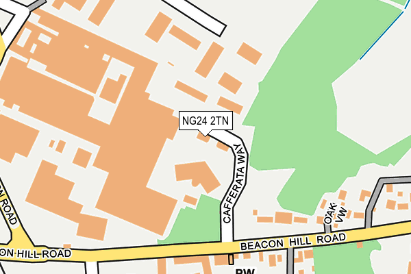
NG24 2TN is located in the Bridge electoral ward, within the local authority district of Newark and Sherwood and the English Parliamentary constituency of Newark. The Sub Integrated Care Board (ICB) Location is NHS Nottingham and Nottinghamshire ICB - 52R and the police force is Nottinghamshire. This postcode has been in use since August 2006.


GetTheData
Source: OS OpenMap – Local (Ordnance Survey)
Source: OS VectorMap District (Ordnance Survey)
Licence: Open Government Licence (requires attribution)
| Easting | 481016 |
| Northing | 354029 |
| Latitude | 53.077749 |
| Longitude | -0.791812 |
GetTheData
Source: Open Postcode Geo
Licence: Open Government Licence
| Country | England |
| Postcode District | NG24 |
➜ See where NG24 is on a map ➜ Where is Newark-on-Trent? | |
GetTheData
Source: Land Registry Price Paid Data
Licence: Open Government Licence
Elevation or altitude of NG24 2TN as distance above sea level:
| Metres | Feet | |
|---|---|---|
| Elevation | 20m | 66ft |
Elevation is measured from the approximate centre of the postcode, to the nearest point on an OS contour line from OS Terrain 50, which has contour spacing of ten vertical metres.
➜ How high above sea level am I? Find the elevation of your current position using your device's GPS.
GetTheData
Source: Open Postcode Elevation
Licence: Open Government Licence
| Ward | Bridge |
| Constituency | Newark |
GetTheData
Source: ONS Postcode Database
Licence: Open Government Licence
| Magdalene View (Beacon Hill Road) | Newark | 158m |
| Magdalene View (Beacon Hill Road) | Newark | 176m |
| Focus (Northern Road) | Newark | 288m |
| Lindum Street (Sleaford Road) | Newark | 454m |
| Lindum Street (Sleaford Road) | Newark | 492m |
| Newark North Gate Station | 0.7km |
| Newark Castle Station | 1.4km |
GetTheData
Source: NaPTAN
Licence: Open Government Licence
GetTheData
Source: ONS Postcode Database
Licence: Open Government Licence


➜ Get more ratings from the Food Standards Agency
GetTheData
Source: Food Standards Agency
Licence: FSA terms & conditions
| Last Collection | |||
|---|---|---|---|
| Location | Mon-Fri | Sat | Distance |
| Northgate Station | 18:30 | 11:30 | 752m |
| Bedehouse Lane | 18:30 | 11:45 | 796m |
| Yorke Drive | 17:30 | 11:45 | 941m |
GetTheData
Source: Dracos
Licence: Creative Commons Attribution-ShareAlike
The below table lists the International Territorial Level (ITL) codes (formerly Nomenclature of Territorial Units for Statistics (NUTS) codes) and Local Administrative Units (LAU) codes for NG24 2TN:
| ITL 1 Code | Name |
|---|---|
| TLF | East Midlands (England) |
| ITL 2 Code | Name |
| TLF1 | Derbyshire and Nottinghamshire |
| ITL 3 Code | Name |
| TLF15 | North Nottinghamshire |
| LAU 1 Code | Name |
| E07000175 | Newark and Sherwood |
GetTheData
Source: ONS Postcode Directory
Licence: Open Government Licence
The below table lists the Census Output Area (OA), Lower Layer Super Output Area (LSOA), and Middle Layer Super Output Area (MSOA) for NG24 2TN:
| Code | Name | |
|---|---|---|
| OA | E00144223 | |
| LSOA | E01028304 | Newark and Sherwood 007B |
| MSOA | E02005899 | Newark and Sherwood 007 |
GetTheData
Source: ONS Postcode Directory
Licence: Open Government Licence
| NG24 2JG | Beacon Hill Road | 140m |
| NG24 2JE | Bottom Row | 161m |
| NG24 2JD | Top Row | 187m |
| NG24 2AG | Jessop Close | 210m |
| NG24 2TX | Oak View | 221m |
| NG24 2HU | Mill Green | 226m |
| NG24 2JJ | Beacon Hill Road | 227m |
| NG24 2JB | Side Row | 228m |
| NG24 2HX | Woodstock Close | 261m |
| NG24 2JA | Stanley Terrace | 269m |
GetTheData
Source: Open Postcode Geo; Land Registry Price Paid Data
Licence: Open Government Licence