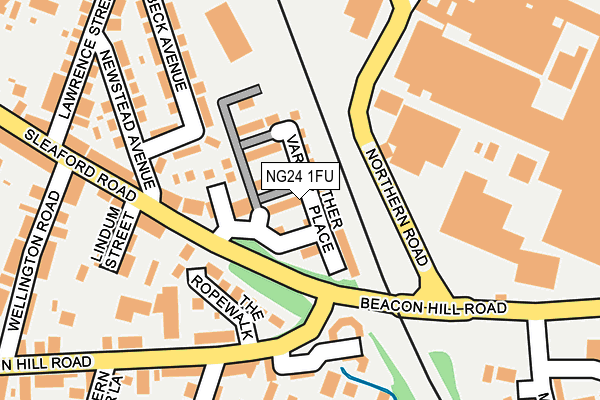
NG24 1FU is located in the Bridge electoral ward, within the local authority district of Newark and Sherwood and the English Parliamentary constituency of Newark. The Sub Integrated Care Board (ICB) Location is NHS Nottingham and Nottinghamshire ICB - 52R and the police force is Nottinghamshire. This postcode has been in use since February 2017.


GetTheData
Source: OS OpenMap – Local (Ordnance Survey)
Source: OS VectorMap District (Ordnance Survey)
Licence: Open Government Licence (requires attribution)
| Easting | 480631 |
| Northing | 354009 |
| Latitude | 53.077253 |
| Longitude | -0.797842 |
GetTheData
Source: Open Postcode Geo
Licence: Open Government Licence
| Country | England |
| Postcode District | NG24 |
➜ See where NG24 is on a map ➜ Where is Newark-on-Trent? | |
GetTheData
Source: Land Registry Price Paid Data
Licence: Open Government Licence
| Ward | Bridge |
| Constituency | Newark |
GetTheData
Source: ONS Postcode Database
Licence: Open Government Licence
| Lindum Street (Sleaford Road) | Newark | 80m |
| Focus (Northern Road) | Newark | 107m |
| Lindum Street (Sleaford Road) | Newark | 111m |
| Magdalene View (Beacon Hill Road) | Newark | 300m |
| Magdalene View (Beacon Hill Road) | Newark | 300m |
| Newark North Gate Station | 0.5km |
| Newark Castle Station | 1.1km |
GetTheData
Source: NaPTAN
Licence: Open Government Licence
| Percentage of properties with Next Generation Access | 100.0% |
| Percentage of properties with Superfast Broadband | 100.0% |
| Percentage of properties with Ultrafast Broadband | 0.0% |
| Percentage of properties with Full Fibre Broadband | 0.0% |
Superfast Broadband is between 30Mbps and 300Mbps
Ultrafast Broadband is > 300Mbps
| Median download speed | 35.2Mbps |
| Average download speed | 28.3Mbps |
| Maximum download speed | 62.67Mbps |
| Median upload speed | 7.3Mbps |
| Average upload speed | 6.2Mbps |
| Maximum upload speed | 20.00Mbps |
| Percentage of properties unable to receive 2Mbps | 0.0% |
| Percentage of properties unable to receive 5Mbps | 0.0% |
| Percentage of properties unable to receive 10Mbps | 0.0% |
| Percentage of properties unable to receive 30Mbps | 0.0% |
GetTheData
Source: Ofcom
Licence: Ofcom Terms of Use (requires attribution)
GetTheData
Source: ONS Postcode Database
Licence: Open Government Licence


➜ Get more ratings from the Food Standards Agency
GetTheData
Source: Food Standards Agency
Licence: FSA terms & conditions
| Last Collection | |||
|---|---|---|---|
| Location | Mon-Fri | Sat | Distance |
| Bedehouse Lane | 18:30 | 11:45 | 424m |
| Northgate Station | 18:30 | 11:30 | 555m |
| Lovers Lane | 18:30 | 11:30 | 603m |
GetTheData
Source: Dracos
Licence: Creative Commons Attribution-ShareAlike
| Risk of NG24 1FU flooding from rivers and sea | Low |
| ➜ NG24 1FU flood map | |
GetTheData
Source: Open Flood Risk by Postcode
Licence: Open Government Licence
The below table lists the International Territorial Level (ITL) codes (formerly Nomenclature of Territorial Units for Statistics (NUTS) codes) and Local Administrative Units (LAU) codes for NG24 1FU:
| ITL 1 Code | Name |
|---|---|
| TLF | East Midlands (England) |
| ITL 2 Code | Name |
| TLF1 | Derbyshire and Nottinghamshire |
| ITL 3 Code | Name |
| TLF15 | North Nottinghamshire |
| LAU 1 Code | Name |
| E07000175 | Newark and Sherwood |
GetTheData
Source: ONS Postcode Directory
Licence: Open Government Licence
The below table lists the Census Output Area (OA), Lower Layer Super Output Area (LSOA), and Middle Layer Super Output Area (MSOA) for NG24 1FU:
| Code | Name | |
|---|---|---|
| OA | E00144207 | |
| LSOA | E01028305 | Newark and Sherwood 007C |
| MSOA | E02005899 | Newark and Sherwood 007 |
GetTheData
Source: ONS Postcode Directory
Licence: Open Government Licence
| NG24 1NS | Harrisons Way | 94m |
| NG24 1NG | Sleaford Road | 100m |
| NG24 1PR | The Ropewalk | 118m |
| NG24 1TY | The Crossings | 142m |
| NG24 1NQ | Sleaford Road | 164m |
| NG24 1LW | Lindum Mews | 166m |
| NG24 1NY | Beacon Hill Road | 176m |
| NG24 1NT | Beacon Hill Road | 185m |
| NG24 1NB | Welbeck Avenue | 188m |
| NG24 1TZ | The Gateway | 189m |
GetTheData
Source: Open Postcode Geo; Land Registry Price Paid Data
Licence: Open Government Licence