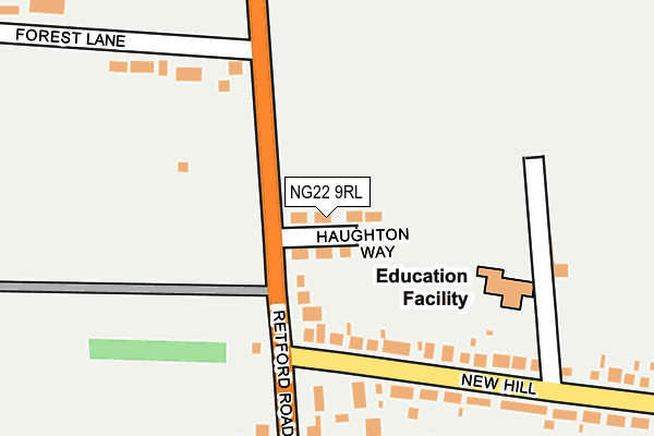
NG22 9RL is located in the Boughton electoral ward, within the local authority district of Newark and Sherwood and the English Parliamentary constituency of Sherwood. The Sub Integrated Care Board (ICB) Location is NHS Nottingham and Nottinghamshire ICB - 52R and the police force is Nottinghamshire. This postcode has been in use since March 2016.


GetTheData
Source: OS OpenMap – Local (Ordnance Survey)
Source: OS VectorMap District (Ordnance Survey)
Licence: Open Government Licence (requires attribution)
| Easting | 467991 |
| Northing | 370999 |
| Latitude | 53.231706 |
| Longitude | -0.982888 |
GetTheData
Source: Open Postcode Geo
Licence: Open Government Licence
| Country | England |
| Postcode District | NG22 |
➜ See where NG22 is on a map | |
GetTheData
Source: Land Registry Price Paid Data
Licence: Open Government Licence
Elevation or altitude of NG22 9RL as distance above sea level:
| Metres | Feet | |
|---|---|---|
| Elevation | 30m | 98ft |
Elevation is measured from the approximate centre of the postcode, to the nearest point on an OS contour line from OS Terrain 50, which has contour spacing of ten vertical metres.
➜ How high above sea level am I? Find the elevation of your current position using your device's GPS.
GetTheData
Source: Open Postcode Elevation
Licence: Open Government Licence
| Ward | Boughton |
| Constituency | Sherwood |
GetTheData
Source: ONS Postcode Database
Licence: Open Government Licence
| New Hill | Walesby | 179m |
| New Hill | Walesby | 190m |
| Retford Road | Walesby | 419m |
| Retford Road | Walesby | 424m |
| Main Street | Walesby | 436m |
GetTheData
Source: NaPTAN
Licence: Open Government Licence
| Percentage of properties with Next Generation Access | 100.0% |
| Percentage of properties with Superfast Broadband | 100.0% |
| Percentage of properties with Ultrafast Broadband | 0.0% |
| Percentage of properties with Full Fibre Broadband | 0.0% |
Superfast Broadband is between 30Mbps and 300Mbps
Ultrafast Broadband is > 300Mbps
| Median download speed | 39.0Mbps |
| Average download speed | 39.4Mbps |
| Maximum download speed | 78.12Mbps |
| Median upload speed | 10.0Mbps |
| Average upload speed | 10.0Mbps |
| Maximum upload speed | 20.00Mbps |
| Percentage of properties unable to receive 2Mbps | 0.0% |
| Percentage of properties unable to receive 5Mbps | 0.0% |
| Percentage of properties unable to receive 10Mbps | 0.0% |
| Percentage of properties unable to receive 30Mbps | 0.0% |
GetTheData
Source: Ofcom
Licence: Ofcom Terms of Use (requires attribution)
GetTheData
Source: ONS Postcode Database
Licence: Open Government Licence


➜ Get more ratings from the Food Standards Agency
GetTheData
Source: Food Standards Agency
Licence: FSA terms & conditions
| Last Collection | |||
|---|---|---|---|
| Location | Mon-Fri | Sat | Distance |
| Retford Road | 16:15 | 10:30 | 124m |
| Walesby Post Office | 16:15 | 10:45 | 451m |
| Church Corner | 16:15 | 10:30 | 469m |
GetTheData
Source: Dracos
Licence: Creative Commons Attribution-ShareAlike
The below table lists the International Territorial Level (ITL) codes (formerly Nomenclature of Territorial Units for Statistics (NUTS) codes) and Local Administrative Units (LAU) codes for NG22 9RL:
| ITL 1 Code | Name |
|---|---|
| TLF | East Midlands (England) |
| ITL 2 Code | Name |
| TLF1 | Derbyshire and Nottinghamshire |
| ITL 3 Code | Name |
| TLF15 | North Nottinghamshire |
| LAU 1 Code | Name |
| E07000175 | Newark and Sherwood |
GetTheData
Source: ONS Postcode Directory
Licence: Open Government Licence
The below table lists the Census Output Area (OA), Lower Layer Super Output Area (LSOA), and Middle Layer Super Output Area (MSOA) for NG22 9RL:
| Code | Name | |
|---|---|---|
| OA | E00144204 | |
| LSOA | E01028303 | Newark and Sherwood 003A |
| MSOA | E02005895 | Newark and Sherwood 003 |
GetTheData
Source: ONS Postcode Directory
Licence: Open Government Licence
| NG22 9PE | Retford Road | 162m |
| NG22 9PD | Forestry Houses | 183m |
| NG22 9PB | New Hill | 260m |
| NG22 9PQ | Kennedy Court | 282m |
| NG22 9NN | Kennedy Rise | 314m |
| NG22 9NP | Chapel Close | 345m |
| NG22 9PF | Forest Lane | 346m |
| NG22 9PJ | The Hawthorns | 376m |
| NG22 9WA | Aspen Close | 394m |
| NG22 9PH | The Brambles | 416m |
GetTheData
Source: Open Postcode Geo; Land Registry Price Paid Data
Licence: Open Government Licence