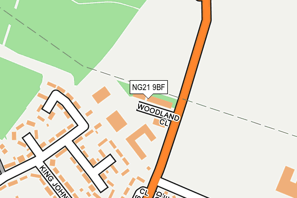
NG21 9BF is located in the Edwinstowe & Clipstone electoral ward, within the local authority district of Newark and Sherwood and the English Parliamentary constituency of Sherwood. The Sub Integrated Care Board (ICB) Location is NHS Nottingham and Nottinghamshire ICB - 52R and the police force is Nottinghamshire. This postcode has been in use since August 1993.


GetTheData
Source: OS OpenMap – Local (Ordnance Survey)
Source: OS VectorMap District (Ordnance Survey)
Licence: Open Government Licence (requires attribution)
| Easting | 459657 |
| Northing | 363801 |
| Latitude | 53.167992 |
| Longitude | -1.109066 |
GetTheData
Source: Open Postcode Geo
Licence: Open Government Licence
| Country | England |
| Postcode District | NG21 |
➜ See where NG21 is on a map ➜ Where is Clipstone? | |
GetTheData
Source: Land Registry Price Paid Data
Licence: Open Government Licence
Elevation or altitude of NG21 9BF as distance above sea level:
| Metres | Feet | |
|---|---|---|
| Elevation | 90m | 295ft |
Elevation is measured from the approximate centre of the postcode, to the nearest point on an OS contour line from OS Terrain 50, which has contour spacing of ten vertical metres.
➜ How high above sea level am I? Find the elevation of your current position using your device's GPS.
GetTheData
Source: Open Postcode Elevation
Licence: Open Government Licence
| Ward | Edwinstowe & Clipstone |
| Constituency | Sherwood |
GetTheData
Source: ONS Postcode Database
Licence: Open Government Licence
| Greendale Crescent (Mansfield Road) | Clipstone | 210m |
| Greendale Crescent (Davis Close) | Clipstone | 210m |
| King Johns Road | Clipstone | 265m |
| Colliery (Mansfield Road) | Clipstone | 447m |
| Colliery (Mansfield Road) | Clipstone | 464m |
GetTheData
Source: NaPTAN
Licence: Open Government Licence
| Median download speed | 49.0Mbps |
| Average download speed | 38.1Mbps |
| Maximum download speed | 68.52Mbps |
| Median upload speed | 9.5Mbps |
| Average upload speed | 7.2Mbps |
| Maximum upload speed | 11.25Mbps |
GetTheData
Source: Ofcom
Licence: Ofcom Terms of Use (requires attribution)
Estimated total energy consumption in NG21 9BF by fuel type, 2015.
| Consumption (kWh) | 52,326 |
|---|---|
| Meter count | 7 |
| Mean (kWh/meter) | 7,475 |
| Median (kWh/meter) | 1 |
GetTheData
Source: Postcode level gas estimates: 2015 (experimental)
Source: Postcode level electricity estimates: 2015 (experimental)
Licence: Open Government Licence
GetTheData
Source: ONS Postcode Database
Licence: Open Government Licence


➜ Get more ratings from the Food Standards Agency
GetTheData
Source: Food Standards Agency
Licence: FSA terms & conditions
| Last Collection | |||
|---|---|---|---|
| Location | Mon-Fri | Sat | Distance |
| Clipstone Colly | 16:15 | 11:00 | 309m |
| Main Road | 16:15 | 11:00 | 617m |
| Hilcote Drive | 16:15 | 11:00 | 731m |
GetTheData
Source: Dracos
Licence: Creative Commons Attribution-ShareAlike
The below table lists the International Territorial Level (ITL) codes (formerly Nomenclature of Territorial Units for Statistics (NUTS) codes) and Local Administrative Units (LAU) codes for NG21 9BF:
| ITL 1 Code | Name |
|---|---|
| TLF | East Midlands (England) |
| ITL 2 Code | Name |
| TLF1 | Derbyshire and Nottinghamshire |
| ITL 3 Code | Name |
| TLF15 | North Nottinghamshire |
| LAU 1 Code | Name |
| E07000175 | Newark and Sherwood |
GetTheData
Source: ONS Postcode Directory
Licence: Open Government Licence
The below table lists the Census Output Area (OA), Lower Layer Super Output Area (LSOA), and Middle Layer Super Output Area (MSOA) for NG21 9BF:
| Code | Name | |
|---|---|---|
| OA | E00144263 | |
| LSOA | E01028313 | Newark and Sherwood 002A |
| MSOA | E02005894 | Newark and Sherwood 002 |
GetTheData
Source: ONS Postcode Directory
Licence: Open Government Licence
| NG21 9FL | Mansfield Road | 74m |
| NG21 9EP | Highfield Road | 173m |
| NG21 9ER | Highfield Road | 203m |
| NG21 9BB | Sherwood Place | 226m |
| NG21 9EW | King Johns Road | 248m |
| NG21 9BD | Greendale Crescent | 269m |
| NG21 9EN | King Johns Road | 292m |
| NG21 9ES | Highfield Road | 329m |
| NG21 9BA | Mansfield Road | 333m |
| NG21 9ET | Highfield Road | 340m |
GetTheData
Source: Open Postcode Geo; Land Registry Price Paid Data
Licence: Open Government Licence