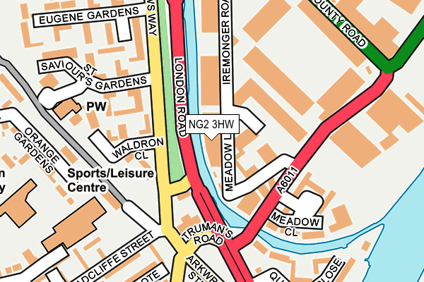
NG2 3HW is located in the Meadows electoral ward, within the unitary authority of Nottingham and the English Parliamentary constituency of Nottingham South. The Sub Integrated Care Board (ICB) Location is NHS Nottingham and Nottinghamshire ICB - 52R and the police force is Nottinghamshire. This postcode has been in use since July 2009.


GetTheData
Source: OS OpenMap – Local (Ordnance Survey)
Source: OS VectorMap District (Ordnance Survey)
Licence: Open Government Licence (requires attribution)
| Easting | 457951 |
| Northing | 338600 |
| Latitude | 52.941692 |
| Longitude | -1.139104 |
GetTheData
Source: Open Postcode Geo
Licence: Open Government Licence
| Country | England |
| Postcode District | NG2 |
➜ See where NG2 is on a map ➜ Where is Nottingham? | |
GetTheData
Source: Land Registry Price Paid Data
Licence: Open Government Licence
Elevation or altitude of NG2 3HW as distance above sea level:
| Metres | Feet | |
|---|---|---|
| Elevation | 30m | 98ft |
Elevation is measured from the approximate centre of the postcode, to the nearest point on an OS contour line from OS Terrain 50, which has contour spacing of ten vertical metres.
➜ How high above sea level am I? Find the elevation of your current position using your device's GPS.
GetTheData
Source: Open Postcode Elevation
Licence: Open Government Licence
| Ward | Meadows |
| Constituency | Nottingham South |
GetTheData
Source: ONS Postcode Database
Licence: Open Government Licence
| London Road Temporary (London Road) | Nottingham | 75m |
| London Road Temporary (London Road) | Nottingham | 104m |
| Ryehill Street (Meadows Way) | Meadows | 115m |
| Ryehill Street (Meadows Way) | Meadows | 127m |
| Eugene Gardens (Meadows Way) | Meadows | 175m |
| Nottingham Station Tram Stop (N/A) | Nottingham | 725m |
| Queens Walk Tram Stop (Queens Walk) | Meadows | 768m |
| Meadows Embankment Tram Stop (Queens Walk) | Meadows | 1,022m |
| Meadows Way West Tram Stop (Meadows Way) | Meadows | 1,197m |
| Wilford Village Tram Stop (Main Road) | Wilford | 1,296m |
| Nottingham Station | 0.8km |
| Netherfield Station | 4.5km |
| Carlton Station | 4.8km |
GetTheData
Source: NaPTAN
Licence: Open Government Licence
GetTheData
Source: ONS Postcode Database
Licence: Open Government Licence


➜ Get more ratings from the Food Standards Agency
GetTheData
Source: Food Standards Agency
Licence: FSA terms & conditions
| Last Collection | |||
|---|---|---|---|
| Location | Mon-Fri | Sat | Distance |
| Eugene Gardens | 18:30 | 12:30 | 208m |
| Cattle Market | 18:45 | 11:30 | 382m |
| Wilford Crescent East | 17:30 | 12:30 | 387m |
GetTheData
Source: Dracos
Licence: Creative Commons Attribution-ShareAlike
| Risk of NG2 3HW flooding from rivers and sea | Low |
| ➜ NG2 3HW flood map | |
GetTheData
Source: Open Flood Risk by Postcode
Licence: Open Government Licence
The below table lists the International Territorial Level (ITL) codes (formerly Nomenclature of Territorial Units for Statistics (NUTS) codes) and Local Administrative Units (LAU) codes for NG2 3HW:
| ITL 1 Code | Name |
|---|---|
| TLF | East Midlands (England) |
| ITL 2 Code | Name |
| TLF1 | Derbyshire and Nottinghamshire |
| ITL 3 Code | Name |
| TLF14 | Nottingham |
| LAU 1 Code | Name |
| E06000018 | Nottingham |
GetTheData
Source: ONS Postcode Directory
Licence: Open Government Licence
The below table lists the Census Output Area (OA), Lower Layer Super Output Area (LSOA), and Middle Layer Super Output Area (MSOA) for NG2 3HW:
| Code | Name | |
|---|---|---|
| OA | E00069976 | |
| LSOA | E01013874 | Nottingham 039A |
| MSOA | E02006904 | Nottingham 039 |
GetTheData
Source: ONS Postcode Directory
Licence: Open Government Licence
| NG2 3LQ | Ladysmock Gardens | 105m |
| NG2 3LP | Waldron Close | 124m |
| NG2 3LJ | Hartford Close | 127m |
| NG2 3BS | London Road | 131m |
| NG2 3HZ | Meadow Close | 151m |
| NG2 3LG | Ryehill Close | 171m |
| NG2 2HY | Arkwright Walk | 193m |
| NG2 3LH | St Saviours Gardens | 200m |
| NG2 2HE | Radcliffe Street | 227m |
| NG2 2JJ | Gosforth Court | 243m |
GetTheData
Source: Open Postcode Geo; Land Registry Price Paid Data
Licence: Open Government Licence