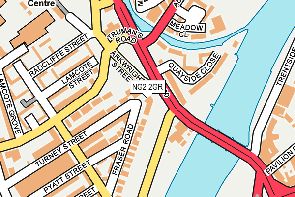
NG2 2GR is located in the Meadows electoral ward, within the unitary authority of Nottingham and the English Parliamentary constituency of Nottingham South. The Sub Integrated Care Board (ICB) Location is NHS Nottingham and Nottinghamshire ICB - 52R and the police force is Nottinghamshire. This postcode has been in use since January 1980.


GetTheData
Source: OS OpenMap – Local (Ordnance Survey)
Source: OS VectorMap District (Ordnance Survey)
Licence: Open Government Licence (requires attribution)
| Easting | 457990 |
| Northing | 338326 |
| Latitude | 52.939205 |
| Longitude | -1.138576 |
GetTheData
Source: Open Postcode Geo
Licence: Open Government Licence
| Country | England |
| Postcode District | NG2 |
➜ See where NG2 is on a map ➜ Where is Nottingham? | |
GetTheData
Source: Land Registry Price Paid Data
Licence: Open Government Licence
Elevation or altitude of NG2 2GR as distance above sea level:
| Metres | Feet | |
|---|---|---|
| Elevation | 30m | 98ft |
Elevation is measured from the approximate centre of the postcode, to the nearest point on an OS contour line from OS Terrain 50, which has contour spacing of ten vertical metres.
➜ How high above sea level am I? Find the elevation of your current position using your device's GPS.
GetTheData
Source: Open Postcode Elevation
Licence: Open Government Licence
| Ward | Meadows |
| Constituency | Nottingham South |
GetTheData
Source: ONS Postcode Database
Licence: Open Government Licence
| Victoria Embankment (Trent Bridge) | Trent Bridge | 17m |
| Victoria Embankment (Trent Bridge) | Trent Bridge | 52m |
| Ryehill Street (Meadows Way) | Meadows | 188m |
| Bunbury Street (Bathley Street) | Meadows | 217m |
| Ryehill Street (Meadows Way) | Meadows | 221m |
| Queens Walk Tram Stop (Queens Walk) | Meadows | 887m |
| Nottingham Station Tram Stop (N/A) | Nottingham | 975m |
| Meadows Embankment Tram Stop (Queens Walk) | Meadows | 1,015m |
| Wilford Village Tram Stop (Main Road) | Wilford | 1,213m |
| Meadows Way West Tram Stop (Meadows Way) | Meadows | 1,303m |
| Nottingham Station | 1km |
| Netherfield Station | 4.7km |
| Carlton Station | 4.9km |
GetTheData
Source: NaPTAN
Licence: Open Government Licence
GetTheData
Source: ONS Postcode Database
Licence: Open Government Licence


➜ Get more ratings from the Food Standards Agency
GetTheData
Source: Food Standards Agency
Licence: FSA terms & conditions
| Last Collection | |||
|---|---|---|---|
| Location | Mon-Fri | Sat | Distance |
| Fraser Road | 17:30 | 12:30 | 268m |
| Radcliffe Road | 17:00 | 12:00 | 350m |
| Wilford Crescent East | 17:30 | 12:30 | 368m |
GetTheData
Source: Dracos
Licence: Creative Commons Attribution-ShareAlike
The below table lists the International Territorial Level (ITL) codes (formerly Nomenclature of Territorial Units for Statistics (NUTS) codes) and Local Administrative Units (LAU) codes for NG2 2GR:
| ITL 1 Code | Name |
|---|---|
| TLF | East Midlands (England) |
| ITL 2 Code | Name |
| TLF1 | Derbyshire and Nottinghamshire |
| ITL 3 Code | Name |
| TLF14 | Nottingham |
| LAU 1 Code | Name |
| E06000018 | Nottingham |
GetTheData
Source: ONS Postcode Directory
Licence: Open Government Licence
The below table lists the Census Output Area (OA), Lower Layer Super Output Area (LSOA), and Middle Layer Super Output Area (MSOA) for NG2 2GR:
| Code | Name | |
|---|---|---|
| OA | E00069966 | |
| LSOA | E01013874 | Nottingham 039A |
| MSOA | E02006904 | Nottingham 039 |
GetTheData
Source: ONS Postcode Directory
Licence: Open Government Licence
| NG2 3BW | Turneys Court | 60m |
| NG2 2LJ | Bathley Street | 109m |
| NG2 3BP | Quayside Close | 118m |
| NG2 2LG | Turney Street | 127m |
| NG2 2LF | Pyatt Street | 135m |
| NG2 2LH | Bathley Street | 155m |
| NG2 2GT | Lamcote Street | 162m |
| NG2 2JZ | Fraser Road | 167m |
| NG2 3BS | London Road | 168m |
| NG2 2GU | Lamcote Street | 173m |
GetTheData
Source: Open Postcode Geo; Land Registry Price Paid Data
Licence: Open Government Licence