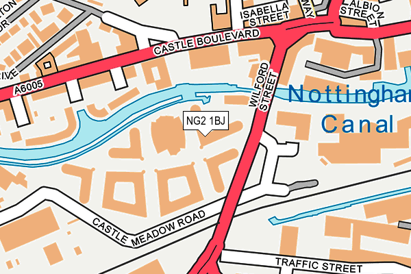
NG2 1BJ is located in the Castle electoral ward, within the unitary authority of Nottingham and the English Parliamentary constituency of Nottingham South. The Sub Integrated Care Board (ICB) Location is NHS Nottingham and Nottinghamshire ICB - 52R and the police force is Nottinghamshire. This postcode has been in use since May 2012.


GetTheData
Source: OS OpenMap – Local (Ordnance Survey)
Source: OS VectorMap District (Ordnance Survey)
Licence: Open Government Licence (requires attribution)
| Easting | 457015 |
| Northing | 339213 |
| Latitude | 52.947281 |
| Longitude | -1.152926 |
GetTheData
Source: Open Postcode Geo
Licence: Open Government Licence
| Country | England |
| Postcode District | NG2 |
➜ See where NG2 is on a map ➜ Where is Nottingham? | |
GetTheData
Source: Land Registry Price Paid Data
Licence: Open Government Licence
Elevation or altitude of NG2 1BJ as distance above sea level:
| Metres | Feet | |
|---|---|---|
| Elevation | 30m | 98ft |
Elevation is measured from the approximate centre of the postcode, to the nearest point on an OS contour line from OS Terrain 50, which has contour spacing of ten vertical metres.
➜ How high above sea level am I? Find the elevation of your current position using your device's GPS.
GetTheData
Source: Open Postcode Elevation
Licence: Open Government Licence
| Ward | Castle |
| Constituency | Nottingham South |
GetTheData
Source: ONS Postcode Database
Licence: Open Government Licence
| Brewhouse Yard Museum (Castle Boulevard) | Castle Marina | 135m |
| Brewhouse Yard Museum (Castle Boulevard) | Castle Marina | 149m |
| Palatine Street (Castle Boulevard) | Castle Marina | 251m |
| Wilford Road (Meadows Way) | Meadows | 255m |
| Canal Street | Nottingham | 266m |
| Nottingham Station Tram Stop (N/A) | Nottingham | 491m |
| Meadows Way West Tram Stop (Meadows Way) | Meadows | 502m |
| Queens Walk Tram Stop (Queens Walk) | Meadows | 531m |
| Old Market Square Tram Stop (South Parade) | Nottingham | 657m |
| Lace Market Tram Stop (Fletcher Gate) | Nottingham | 822m |
| Nottingham Station | 0.4km |
| Beeston Station | 4.7km |
| Netherfield Station | 5.2km |
GetTheData
Source: NaPTAN
Licence: Open Government Licence
GetTheData
Source: ONS Postcode Database
Licence: Open Government Licence


➜ Get more ratings from the Food Standards Agency
GetTheData
Source: Food Standards Agency
Licence: FSA terms & conditions
| Last Collection | |||
|---|---|---|---|
| Location | Mon-Fri | Sat | Distance |
| Castle Boulevard | 17:30 | 11:30 | 219m |
| Maid Marion Way | 18:30 | 11:00 | 266m |
| Carrington Street | 18:45 | 12:30 | 404m |
GetTheData
Source: Dracos
Licence: Creative Commons Attribution-ShareAlike
| Risk of NG2 1BJ flooding from rivers and sea | Low |
| ➜ NG2 1BJ flood map | |
GetTheData
Source: Open Flood Risk by Postcode
Licence: Open Government Licence
The below table lists the International Territorial Level (ITL) codes (formerly Nomenclature of Territorial Units for Statistics (NUTS) codes) and Local Administrative Units (LAU) codes for NG2 1BJ:
| ITL 1 Code | Name |
|---|---|
| TLF | East Midlands (England) |
| ITL 2 Code | Name |
| TLF1 | Derbyshire and Nottinghamshire |
| ITL 3 Code | Name |
| TLF14 | Nottingham |
| LAU 1 Code | Name |
| E06000018 | Nottingham |
GetTheData
Source: ONS Postcode Directory
Licence: Open Government Licence
The below table lists the Census Output Area (OA), Lower Layer Super Output Area (LSOA), and Middle Layer Super Output Area (MSOA) for NG2 1BJ:
| Code | Name | |
|---|---|---|
| OA | E00070001 | |
| LSOA | E01013870 | Nottingham 040A |
| MSOA | E02006905 | Nottingham 040 |
GetTheData
Source: ONS Postcode Directory
Licence: Open Government Licence
| NG7 1GD | Wharf Road | 133m |
| NG7 1FD | Castle Boulevard | 146m |
| NG7 1FA | Park Wharf | 199m |
| NG7 1FE | Castle Boulevard | 201m |
| NG7 1FL | Castle Boulevard | 203m |
| NG7 1BT | Hope Drive | 250m |
| NG7 1FF | Woodsend Wharf | 265m |
| NG7 1FG | Palatine Street | 272m |
| NG7 1DL | Hope Drive | 283m |
| NG7 1DE | Peveril Drive | 301m |
GetTheData
Source: Open Postcode Geo; Land Registry Price Paid Data
Licence: Open Government Licence
| Castle Road | At Any Time | 338m |
| Stanford Street | At Any Time | 415m |
| Station Street | 7.30am-midnight | 426m |
GetTheData
Source: Disabled parking spaces, Nottingham City Council, 19/02/2013
Licence: Open Government Licence