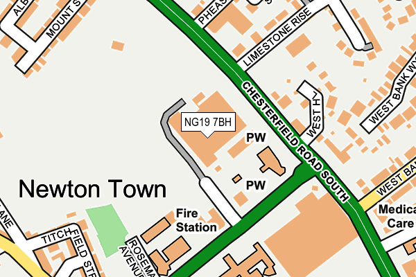
NG19 7BH is located in the West Bank electoral ward, within the local authority district of Mansfield and the English Parliamentary constituency of Mansfield. The Sub Integrated Care Board (ICB) Location is NHS Nottingham and Nottinghamshire ICB - 52R and the police force is Nottinghamshire. This postcode has been in use since April 1987.


GetTheData
Source: OS OpenMap – Local (Ordnance Survey)
Source: OS VectorMap District (Ordnance Survey)
Licence: Open Government Licence (requires attribution)
| Easting | 453271 |
| Northing | 361848 |
| Latitude | 53.151114 |
| Longitude | -1.204905 |
GetTheData
Source: Open Postcode Geo
Licence: Open Government Licence
| Country | England |
| Postcode District | NG19 |
➜ See where NG19 is on a map ➜ Where is Mansfield? | |
GetTheData
Source: Land Registry Price Paid Data
Licence: Open Government Licence
Elevation or altitude of NG19 7BH as distance above sea level:
| Metres | Feet | |
|---|---|---|
| Elevation | 110m | 361ft |
Elevation is measured from the approximate centre of the postcode, to the nearest point on an OS contour line from OS Terrain 50, which has contour spacing of ten vertical metres.
➜ How high above sea level am I? Find the elevation of your current position using your device's GPS.
GetTheData
Source: Open Postcode Elevation
Licence: Open Government Licence
| Ward | West Bank |
| Constituency | Mansfield |
GetTheData
Source: ONS Postcode Database
Licence: Open Government Licence
| Council Offices (Chesterfield Road South) | Mansfield | 95m |
| Fire Station (Rosemary Street) | Mansfield | 148m |
| Fire Station (Rosemary Street) | Mansfield | 175m |
| St Philip Neri School Bus Park (Bus Park) | Mansfield | 176m |
| Council Offices (Chesterfield Road South) | Mansfield | 186m |
| Mansfield Station | 1.1km |
| Mansfield Woodhouse Station | 1.4km |
| Sutton Parkway Station | 4.9km |
GetTheData
Source: NaPTAN
Licence: Open Government Licence
GetTheData
Source: ONS Postcode Database
Licence: Open Government Licence


➜ Get more ratings from the Food Standards Agency
GetTheData
Source: Food Standards Agency
Licence: FSA terms & conditions
| Last Collection | |||
|---|---|---|---|
| Location | Mon-Fri | Sat | Distance |
| West Bank Avenue | 19:00 | 11:00 | 452m |
| Mansfield Old Delivery Office | 19:30 | 12:00 | 1,057m |
| Moor Lane | 17:30 | 11:00 | 1,305m |
GetTheData
Source: Dracos
Licence: Creative Commons Attribution-ShareAlike
The below table lists the International Territorial Level (ITL) codes (formerly Nomenclature of Territorial Units for Statistics (NUTS) codes) and Local Administrative Units (LAU) codes for NG19 7BH:
| ITL 1 Code | Name |
|---|---|
| TLF | East Midlands (England) |
| ITL 2 Code | Name |
| TLF1 | Derbyshire and Nottinghamshire |
| ITL 3 Code | Name |
| TLF15 | North Nottinghamshire |
| LAU 1 Code | Name |
| E07000174 | Mansfield |
GetTheData
Source: ONS Postcode Directory
Licence: Open Government Licence
The below table lists the Census Output Area (OA), Lower Layer Super Output Area (LSOA), and Middle Layer Super Output Area (MSOA) for NG19 7BH:
| Code | Name | |
|---|---|---|
| OA | E00143826 | |
| LSOA | E01028227 | Mansfield 008A |
| MSOA | E02005887 | Mansfield 008 |
GetTheData
Source: ONS Postcode Directory
Licence: Open Government Licence
| NG19 7AQ | Chesterfield Road South | 149m |
| NG19 6AB | Rosemary Street | 168m |
| NG19 7AH | West Hill | 190m |
| NG19 6AD | Rosemary Avenue | 200m |
| NG19 7AN | Charles Street | 227m |
| NG19 7AZ | Limestone Rise | 228m |
| NG19 7AL | Pheasant Hill | 234m |
| NG19 6AF | Titchfield Street | 237m |
| NG19 6AG | Titchfield Street | 254m |
| NG19 7DQ | West Bank Wynd | 260m |
GetTheData
Source: Open Postcode Geo; Land Registry Price Paid Data
Licence: Open Government Licence