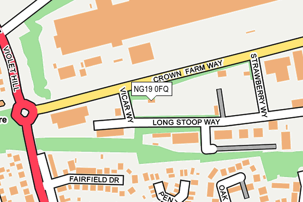
NG19 0FQ is located in the Ling Forest electoral ward, within the local authority district of Mansfield and the English Parliamentary constituency of Mansfield. The Sub Integrated Care Board (ICB) Location is NHS Nottingham and Nottinghamshire ICB - 52R and the police force is Nottinghamshire. This postcode has been in use since July 1995.


GetTheData
Source: OS OpenMap – Local (Ordnance Survey)
Source: OS VectorMap District (Ordnance Survey)
Licence: Open Government Licence (requires attribution)
| Easting | 456571 |
| Northing | 361500 |
| Latitude | 53.147665 |
| Longitude | -1.155626 |
GetTheData
Source: Open Postcode Geo
Licence: Open Government Licence
| Country | England |
| Postcode District | NG19 |
➜ See where NG19 is on a map ➜ Where is Forest Town? | |
GetTheData
Source: Land Registry Price Paid Data
Licence: Open Government Licence
Elevation or altitude of NG19 0FQ as distance above sea level:
| Metres | Feet | |
|---|---|---|
| Elevation | 110m | 361ft |
Elevation is measured from the approximate centre of the postcode, to the nearest point on an OS contour line from OS Terrain 50, which has contour spacing of ten vertical metres.
➜ How high above sea level am I? Find the elevation of your current position using your device's GPS.
GetTheData
Source: Open Postcode Elevation
Licence: Open Government Licence
| Ward | Ling Forest |
| Constituency | Mansfield |
GetTheData
Source: ONS Postcode Database
Licence: Open Government Licence
| Penzance Place (Eakring Road) | Mansfield | 273m |
| Penzance Place (Eakring Place) | Mansfield | 278m |
| Oak Tree Lane (Eakring Road) | Mansfield | 286m |
| Oak Tree Lane (Eakring Road) | Mansfield | 294m |
| Charnwood Grove (Eakring Road) | Mansfield | 393m |
| Mansfield Station | 2.9km |
| Mansfield Woodhouse Station | 3.6km |
GetTheData
Source: NaPTAN
Licence: Open Government Licence
GetTheData
Source: ONS Postcode Database
Licence: Open Government Licence


➜ Get more ratings from the Food Standards Agency
GetTheData
Source: Food Standards Agency
Licence: FSA terms & conditions
| Last Collection | |||
|---|---|---|---|
| Location | Mon-Fri | Sat | Distance |
| Bramble Lane | 17:00 | 11:00 | 1,273m |
| Ratcliffe Gate | 17:30 | 11:00 | 1,291m |
| Berry Hill Road | 17:00 | 11:00 | 1,496m |
GetTheData
Source: Dracos
Licence: Creative Commons Attribution-ShareAlike
The below table lists the International Territorial Level (ITL) codes (formerly Nomenclature of Territorial Units for Statistics (NUTS) codes) and Local Administrative Units (LAU) codes for NG19 0FQ:
| ITL 1 Code | Name |
|---|---|
| TLF | East Midlands (England) |
| ITL 2 Code | Name |
| TLF1 | Derbyshire and Nottinghamshire |
| ITL 3 Code | Name |
| TLF15 | North Nottinghamshire |
| LAU 1 Code | Name |
| E07000174 | Mansfield |
GetTheData
Source: ONS Postcode Directory
Licence: Open Government Licence
The below table lists the Census Output Area (OA), Lower Layer Super Output Area (LSOA), and Middle Layer Super Output Area (MSOA) for NG19 0FQ:
| Code | Name | |
|---|---|---|
| OA | E00143996 | |
| LSOA | E01028262 | Mansfield 011C |
| MSOA | E02005890 | Mansfield 011 |
GetTheData
Source: ONS Postcode Directory
Licence: Open Government Licence
| NG18 3ER | Penzance Place | 183m |
| NG18 3EQ | Fairfield Drive | 207m |
| NG18 3EN | Oak Tree Close | 229m |
| NG18 3EJ | The Villas | 251m |
| NG18 3EH | Eakring Road | 252m |
| NG18 3DR | Forest Court | 286m |
| NG18 3EY | Eakring Road | 305m |
| NG18 3EG | Violet Hill | 315m |
| NG19 0AT | Violet Hill | 321m |
| NG18 3GD | Wollaton Close | 327m |
GetTheData
Source: Open Postcode Geo; Land Registry Price Paid Data
Licence: Open Government Licence