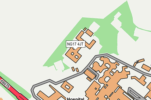
NG17 4JT is located in the Skegby electoral ward, within the local authority district of Ashfield and the English Parliamentary constituency of Ashfield. The Sub Integrated Care Board (ICB) Location is NHS Nottingham and Nottinghamshire ICB - 52R and the police force is Nottinghamshire. This postcode has been in use since May 2013.


GetTheData
Source: OS OpenMap – Local (Ordnance Survey)
Source: OS VectorMap District (Ordnance Survey)
Licence: Open Government Licence (requires attribution)
| Easting | 451140 |
| Northing | 360233 |
| Latitude | 53.136825 |
| Longitude | -1.237022 |
GetTheData
Source: Open Postcode Geo
Licence: Open Government Licence
| Country | England |
| Postcode District | NG17 |
➜ See where NG17 is on a map ➜ Where is Sutton in Ashfield? | |
GetTheData
Source: Land Registry Price Paid Data
Licence: Open Government Licence
Elevation or altitude of NG17 4JT as distance above sea level:
| Metres | Feet | |
|---|---|---|
| Elevation | 150m | 492ft |
Elevation is measured from the approximate centre of the postcode, to the nearest point on an OS contour line from OS Terrain 50, which has contour spacing of ten vertical metres.
➜ How high above sea level am I? Find the elevation of your current position using your device's GPS.
GetTheData
Source: Open Postcode Elevation
Licence: Open Government Licence
| Ward | Skegby |
| Constituency | Ashfield |
GetTheData
Source: ONS Postcode Database
Licence: Open Government Licence
| Kings Mill Hospital (A38) | Sutton In Ashfield | 500m |
| Kings Mill Hospital (Mansfield Road) | Sutton In Ashfield | 526m |
| Beck Lane | Dalestorth | 561m |
| B & Q Warehouse (Mansfield Road) | Sutton Forest Side | 562m |
| Beck Lane | Dalestorth | 572m |
| Sutton Parkway Station | 2.6km |
| Mansfield Station | 2.6km |
| Mansfield Woodhouse Station | 3.8km |
GetTheData
Source: NaPTAN
Licence: Open Government Licence
GetTheData
Source: ONS Postcode Database
Licence: Open Government Licence


➜ Get more ratings from the Food Standards Agency
GetTheData
Source: Food Standards Agency
Licence: FSA terms & conditions
| Last Collection | |||
|---|---|---|---|
| Location | Mon-Fri | Sat | Distance |
| Kings Mill Hospital | 17:00 | 11:00 | 445m |
| Dalestorth Road | 17:00 | 11:00 | 692m |
| Forest Side Post Office | 17:00 | 11:00 | 770m |
GetTheData
Source: Dracos
Licence: Creative Commons Attribution-ShareAlike
The below table lists the International Territorial Level (ITL) codes (formerly Nomenclature of Territorial Units for Statistics (NUTS) codes) and Local Administrative Units (LAU) codes for NG17 4JT:
| ITL 1 Code | Name |
|---|---|
| TLF | East Midlands (England) |
| ITL 2 Code | Name |
| TLF1 | Derbyshire and Nottinghamshire |
| ITL 3 Code | Name |
| TLF15 | North Nottinghamshire |
| LAU 1 Code | Name |
| E07000170 | Ashfield |
GetTheData
Source: ONS Postcode Directory
Licence: Open Government Licence
The below table lists the Census Output Area (OA), Lower Layer Super Output Area (LSOA), and Middle Layer Super Output Area (MSOA) for NG17 4JT:
| Code | Name | |
|---|---|---|
| OA | E00142572 | |
| LSOA | E01027985 | Ashfield 004E |
| MSOA | E02005822 | Ashfield 004 |
GetTheData
Source: ONS Postcode Directory
Licence: Open Government Licence
| NG19 6PG | Skegby Lane | 347m |
| NG17 4JX | Stonehills Way | 354m |
| NG17 4JN | Broadlands Close | 356m |
| NG17 4JQ | Blackmires Way | 390m |
| NG17 3EW | Grendon Way | 399m |
| NG17 4JS | High Oakham Close | 407m |
| NG17 3FA | Grafton Close | 447m |
| NG17 4NS | Harriers Grove | 448m |
| NG17 4HY | Roosevelt Road | 450m |
| NG17 4HX | Lawrence Crescent | 506m |
GetTheData
Source: Open Postcode Geo; Land Registry Price Paid Data
Licence: Open Government Licence