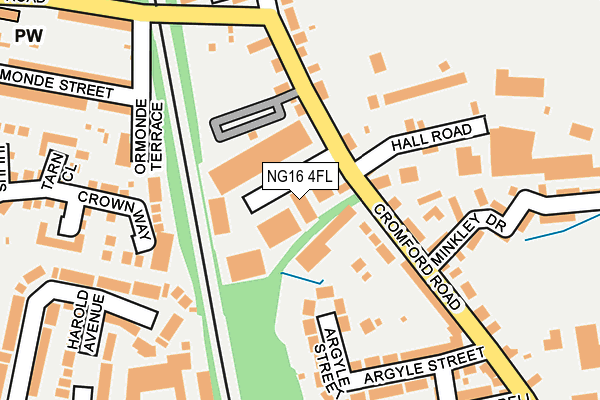
NG16 4FL lies on Cromford Road Industrial Estate in Langley Mill, Nottingham. NG16 4FL is located in the Codnor, Langley Mill & Aldercar electoral ward, within the local authority district of Amber Valley and the English Parliamentary constituency of Amber Valley. The Sub Integrated Care Board (ICB) Location is NHS Derby and Derbyshire ICB - 15M and the police force is Derbyshire. This postcode has been in use since January 1980.


GetTheData
Source: OS OpenMap – Local (Ordnance Survey)
Source: OS VectorMap District (Ordnance Survey)
Licence: Open Government Licence (requires attribution)
| Easting | 444939 |
| Northing | 347717 |
| Latitude | 53.024865 |
| Longitude | -1.331452 |
GetTheData
Source: Open Postcode Geo
Licence: Open Government Licence
| Street | Cromford Road Industrial Estate |
| Locality | Langley Mill |
| Town/City | Nottingham |
| Country | England |
| Postcode District | NG16 |
➜ See where NG16 is on a map ➜ Where is Heanor? | |
GetTheData
Source: Land Registry Price Paid Data
Licence: Open Government Licence
Elevation or altitude of NG16 4FL as distance above sea level:
| Metres | Feet | |
|---|---|---|
| Elevation | 70m | 230ft |
Elevation is measured from the approximate centre of the postcode, to the nearest point on an OS contour line from OS Terrain 50, which has contour spacing of ten vertical metres.
➜ How high above sea level am I? Find the elevation of your current position using your device's GPS.
GetTheData
Source: Open Postcode Elevation
Licence: Open Government Licence
| Ward | Codnor, Langley Mill & Aldercar |
| Constituency | Amber Valley |
GetTheData
Source: ONS Postcode Database
Licence: Open Government Licence
UNIT 10, CROMFORD ROAD INDUSTRIAL ESTATE, LANGLEY MILL, NOTTINGHAM, NG16 4FL 2009 18 MAR £191,000 |
GetTheData
Source: HM Land Registry Price Paid Data
Licence: Contains HM Land Registry data © Crown copyright and database right 2025. This data is licensed under the Open Government Licence v3.0.
| Plumptre Road (Cromford Road) | Aldercar | 197m |
| Plumptre Road (Cromford Road) | Aldercar | 201m |
| Gladstone Street (Cromford Road) | Langley Mill | 211m |
| Gladstone Street (Cromford Road) | Langley Mill | 328m |
| Godkin Drive (Upper Dunstead Road) | Aldercar | 361m |
| Langley Mill Station | 0.8km |
GetTheData
Source: NaPTAN
Licence: Open Government Licence
GetTheData
Source: ONS Postcode Database
Licence: Open Government Licence


➜ Get more ratings from the Food Standards Agency
GetTheData
Source: Food Standards Agency
Licence: FSA terms & conditions
| Last Collection | |||
|---|---|---|---|
| Location | Mon-Fri | Sat | Distance |
| Cromford Road | 17:30 | 11:30 | 91m |
| Dunstead Road | 17:30 | 11:45 | 469m |
| Langley Mill Post Office | 17:00 | 11:45 | 518m |
GetTheData
Source: Dracos
Licence: Creative Commons Attribution-ShareAlike
The below table lists the International Territorial Level (ITL) codes (formerly Nomenclature of Territorial Units for Statistics (NUTS) codes) and Local Administrative Units (LAU) codes for NG16 4FL:
| ITL 1 Code | Name |
|---|---|
| TLF | East Midlands (England) |
| ITL 2 Code | Name |
| TLF1 | Derbyshire and Nottinghamshire |
| ITL 3 Code | Name |
| TLF13 | South and West Derbyshire |
| LAU 1 Code | Name |
| E07000032 | Amber Valley |
GetTheData
Source: ONS Postcode Directory
Licence: Open Government Licence
The below table lists the Census Output Area (OA), Lower Layer Super Output Area (LSOA), and Middle Layer Super Output Area (MSOA) for NG16 4FL:
| Code | Name | |
|---|---|---|
| OA | E00098376 | |
| LSOA | E01019451 | Amber Valley 012D |
| MSOA | E02004040 | Amber Valley 012 |
GetTheData
Source: ONS Postcode Directory
Licence: Open Government Licence
| NG16 4EU | Cromford Road | 106m |
| NG16 4EX | Cromford Road | 111m |
| NG16 4JB | Limes Close | 156m |
| NG16 4ET | Argyle Street | 174m |
| NG16 4FG | Ormonde Terrace | 182m |
| NG16 4JA | Minkley Drive | 182m |
| NG16 4GU | Crown Way | 194m |
| NG16 4DY | Edward Street | 225m |
| NG16 4JD | Cherry Tree Way | 227m |
| NG16 4HF | Bella Close | 241m |
GetTheData
Source: Open Postcode Geo; Land Registry Price Paid Data
Licence: Open Government Licence