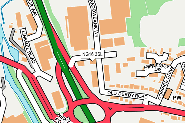
NG16 3SL is located in the Eastwood St Mary's electoral ward, within the local authority district of Broxtowe and the English Parliamentary constituency of Ashfield. The Sub Integrated Care Board (ICB) Location is NHS Nottingham and Nottinghamshire ICB - 52R and the police force is Nottinghamshire. This postcode has been in use since July 1995.


GetTheData
Source: OS OpenMap – Local (Ordnance Survey)
Source: OS VectorMap District (Ordnance Survey)
Licence: Open Government Licence (requires attribution)
| Easting | 445714 |
| Northing | 347127 |
| Latitude | 53.019496 |
| Longitude | -1.319982 |
GetTheData
Source: Open Postcode Geo
Licence: Open Government Licence
| Country | England |
| Postcode District | NG16 |
➜ See where NG16 is on a map ➜ Where is Eastwood? | |
GetTheData
Source: Land Registry Price Paid Data
Licence: Open Government Licence
Elevation or altitude of NG16 3SL as distance above sea level:
| Metres | Feet | |
|---|---|---|
| Elevation | 70m | 230ft |
Elevation is measured from the approximate centre of the postcode, to the nearest point on an OS contour line from OS Terrain 50, which has contour spacing of ten vertical metres.
➜ How high above sea level am I? Find the elevation of your current position using your device's GPS.
GetTheData
Source: Open Postcode Elevation
Licence: Open Government Licence
| Ward | Eastwood St Mary's |
| Constituency | Ashfield |
GetTheData
Source: ONS Postcode Database
Licence: Open Government Licence
| Business Park (Derby Road) | Langley Mill | 273m |
| Park Avenue (Derby Road) | Eastwood | 335m |
| Lidl (Enterprise Way) | Langley Mill | 338m |
| Ryemere Close (Bailey Grove Road) | Eastwood | 393m |
| Park Avenue (Derby Road) | Eastwood | 396m |
| Langley Mill Station | 0.8km |
| Ilkeston Station | 4.7km |
GetTheData
Source: NaPTAN
Licence: Open Government Licence
GetTheData
Source: ONS Postcode Database
Licence: Open Government Licence


➜ Get more ratings from the Food Standards Agency
GetTheData
Source: Food Standards Agency
Licence: FSA terms & conditions
| Last Collection | |||
|---|---|---|---|
| Location | Mon-Fri | Sat | Distance |
| Eastwood Delivery Office | 18:30 | 88m | |
| Derby Road | 17:30 | 12:00 | 370m |
| Langley Mill Post Office | 17:00 | 11:45 | 654m |
GetTheData
Source: Dracos
Licence: Creative Commons Attribution-ShareAlike
The below table lists the International Territorial Level (ITL) codes (formerly Nomenclature of Territorial Units for Statistics (NUTS) codes) and Local Administrative Units (LAU) codes for NG16 3SL:
| ITL 1 Code | Name |
|---|---|
| TLF | East Midlands (England) |
| ITL 2 Code | Name |
| TLF1 | Derbyshire and Nottinghamshire |
| ITL 3 Code | Name |
| TLF16 | South Nottinghamshire |
| LAU 1 Code | Name |
| E07000172 | Broxtowe |
GetTheData
Source: ONS Postcode Directory
Licence: Open Government Licence
The below table lists the Census Output Area (OA), Lower Layer Super Output Area (LSOA), and Middle Layer Super Output Area (MSOA) for NG16 3SL:
| Code | Name | |
|---|---|---|
| OA | E00143250 | |
| LSOA | E01028111 | Broxtowe 002B |
| MSOA | E02005851 | Broxtowe 002 |
GetTheData
Source: ONS Postcode Directory
Licence: Open Government Licence
| NG16 3SB | Meadowbank Way | 109m |
| NG16 3RQ | Harlequin Court | 138m |
| NG16 3SF | Old Derby Road | 150m |
| NG16 3RZ | Linkmel Road | 172m |
| NG16 3RS | Helmsley Drive | 181m |
| NG16 3RR | Ambleside Drive | 200m |
| NG16 3RT | Dawlish Court | 251m |
| NG16 3PN | Fern Crescent | 293m |
| NG16 3NZ | Derby Road | 314m |
| NG16 3PL | Coppice Drive | 319m |
GetTheData
Source: Open Postcode Geo; Land Registry Price Paid Data
Licence: Open Government Licence