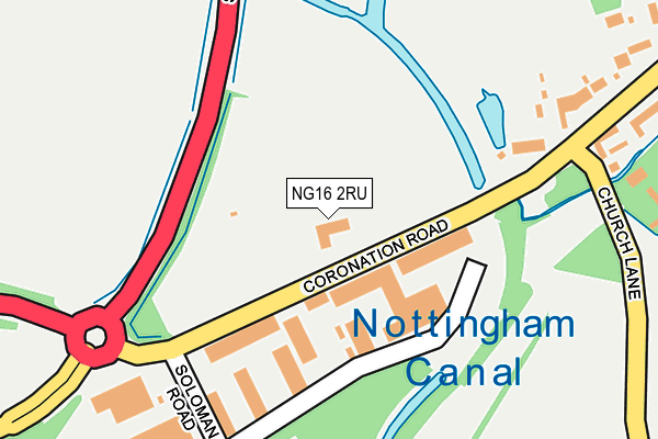
NG16 2RU lies on Coronation Road in Cossall, Nottingham. NG16 2RU is located in the Awsworth, Cossall & Trowell electoral ward, within the local authority district of Broxtowe and the English Parliamentary constituency of Broxtowe. The Sub Integrated Care Board (ICB) Location is NHS Nottingham and Nottinghamshire ICB - 52R and the police force is Nottinghamshire. This postcode has been in use since January 1980.


GetTheData
Source: OS OpenMap – Local (Ordnance Survey)
Source: OS VectorMap District (Ordnance Survey)
Licence: Open Government Licence (requires attribution)
| Easting | 447984 |
| Northing | 342881 |
| Latitude | 52.981152 |
| Longitude | -1.286771 |
GetTheData
Source: Open Postcode Geo
Licence: Open Government Licence
| Street | Coronation Road |
| Locality | Cossall |
| Town/City | Nottingham |
| Country | England |
| Postcode District | NG16 |
➜ See where NG16 is on a map ➜ Where is Cossall? | |
GetTheData
Source: Land Registry Price Paid Data
Licence: Open Government Licence
Elevation or altitude of NG16 2RU as distance above sea level:
| Metres | Feet | |
|---|---|---|
| Elevation | 60m | 197ft |
Elevation is measured from the approximate centre of the postcode, to the nearest point on an OS contour line from OS Terrain 50, which has contour spacing of ten vertical metres.
➜ How high above sea level am I? Find the elevation of your current position using your device's GPS.
GetTheData
Source: Open Postcode Elevation
Licence: Open Government Licence
| Ward | Awsworth, Cossall & Trowell |
| Constituency | Broxtowe |
GetTheData
Source: ONS Postcode Database
Licence: Open Government Licence
CHATTERLEY HOUSE HOTEL, CORONATION ROAD, COSSALL, NOTTINGHAM, NG16 2RU 2007 2 APR £195,000 |
GetTheData
Source: HM Land Registry Price Paid Data
Licence: Contains HM Land Registry data © Crown copyright and database right 2025. This data is licensed under the Open Government Licence v3.0.
| Church Lane (Awsworth Lane) | Cossall Marsh | 43m |
| Church Lane (Awsworth Lane) | Cossall Marsh | 68m |
| Awsworth Lane | Cossall Marsh | 307m |
| Awsworth Lane | Cossall Marsh | 319m |
| Soloman Road (Coronation Road) | Cossall Marsh | 343m |
| Ilkeston Station | 0.6km |
| Langley Mill Station | 5.1km |
GetTheData
Source: NaPTAN
Licence: Open Government Licence
GetTheData
Source: ONS Postcode Database
Licence: Open Government Licence


➜ Get more ratings from the Food Standards Agency
GetTheData
Source: Food Standards Agency
Licence: FSA terms & conditions
| Last Collection | |||
|---|---|---|---|
| Location | Mon-Fri | Sat | Distance |
| Cossall Marsh | 16:00 | 10:30 | 320m |
| Ilkeston Junction | 17:30 | 07:15 | 692m |
| Cossall | 16:00 | 10:30 | 713m |
GetTheData
Source: Dracos
Licence: Creative Commons Attribution-ShareAlike
The below table lists the International Territorial Level (ITL) codes (formerly Nomenclature of Territorial Units for Statistics (NUTS) codes) and Local Administrative Units (LAU) codes for NG16 2RU:
| ITL 1 Code | Name |
|---|---|
| TLF | East Midlands (England) |
| ITL 2 Code | Name |
| TLF1 | Derbyshire and Nottinghamshire |
| ITL 3 Code | Name |
| TLF16 | South Nottinghamshire |
| LAU 1 Code | Name |
| E07000172 | Broxtowe |
GetTheData
Source: ONS Postcode Directory
Licence: Open Government Licence
The below table lists the Census Output Area (OA), Lower Layer Super Output Area (LSOA), and Middle Layer Super Output Area (MSOA) for NG16 2RU:
| Code | Name | |
|---|---|---|
| OA | E00143193 | |
| LSOA | E01028106 | Broxtowe 016B |
| MSOA | E02006906 | Broxtowe 016 |
GetTheData
Source: ONS Postcode Directory
Licence: Open Government Licence
| NG16 2RZ | Awsworth Lane | 316m |
| DE7 5UA | Soloman Road | 326m |
| NG16 2SA | Awsworth Lane | 328m |
| NG16 2SE | 467m | |
| NG16 2RW | Church Lane | 483m |
| NG16 2SB | Newtons Lane | 652m |
| NG16 2SJ | Newtons Lane | 695m |
| DE7 5TE | Station Street | 711m |
| NG16 2SF | Newtons Lane | 720m |
| NG16 2YH | Newtons Lane | 722m |
GetTheData
Source: Open Postcode Geo; Land Registry Price Paid Data
Licence: Open Government Licence