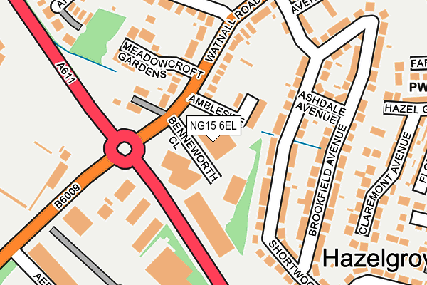
NG15 6EL is located in the Hucknall South electoral ward, within the local authority district of Ashfield and the English Parliamentary constituency of Sherwood. The Sub Integrated Care Board (ICB) Location is NHS Nottingham and Nottinghamshire ICB - 52R and the police force is Nottinghamshire. This postcode has been in use since January 1983.


GetTheData
Source: OS OpenMap – Local (Ordnance Survey)
Source: OS VectorMap District (Ordnance Survey)
Licence: Open Government Licence (requires attribution)
| Easting | 452877 |
| Northing | 348248 |
| Latitude | 53.028933 |
| Longitude | -1.213026 |
GetTheData
Source: Open Postcode Geo
Licence: Open Government Licence
| Country | England |
| Postcode District | NG15 |
➜ See where NG15 is on a map ➜ Where is Hucknall? | |
GetTheData
Source: Land Registry Price Paid Data
Licence: Open Government Licence
Elevation or altitude of NG15 6EL as distance above sea level:
| Metres | Feet | |
|---|---|---|
| Elevation | 90m | 295ft |
Elevation is measured from the approximate centre of the postcode, to the nearest point on an OS contour line from OS Terrain 50, which has contour spacing of ten vertical metres.
➜ How high above sea level am I? Find the elevation of your current position using your device's GPS.
GetTheData
Source: Open Postcode Elevation
Licence: Open Government Licence
| Ward | Hucknall South |
| Constituency | Sherwood |
GetTheData
Source: ONS Postcode Database
Licence: Open Government Licence
| High Leys Road (Watnall Road) | Hazelgrove | 108m |
| High Leys Road (Watnall Road) | Hazelgrove | 123m |
| Football Ground (Watnall Road) | Ruffs Estate | 214m |
| Football Ground (Watnall Road) | Ruffs Estate | 238m |
| Long Hill Rise (Watnall Road) | Hazelgrove | 312m |
| Hucknall Tram Stop (Station Road) | Hucknall | 1,556m |
| Hucknall Station | 1.6km |
| Bulwell Station | 3.4km |
| Newstead Station | 4.6km |
GetTheData
Source: NaPTAN
Licence: Open Government Licence
GetTheData
Source: ONS Postcode Database
Licence: Open Government Licence


➜ Get more ratings from the Food Standards Agency
GetTheData
Source: Food Standards Agency
Licence: FSA terms & conditions
| Last Collection | |||
|---|---|---|---|
| Location | Mon-Fri | Sat | Distance |
| Watnall Road Ind Est | 18:45 | 211m | |
| Farleys Lane | 16:00 | 12:30 | 386m |
| Longhill Rise | 16:00 | 12:30 | 388m |
GetTheData
Source: Dracos
Licence: Creative Commons Attribution-ShareAlike
The below table lists the International Territorial Level (ITL) codes (formerly Nomenclature of Territorial Units for Statistics (NUTS) codes) and Local Administrative Units (LAU) codes for NG15 6EL:
| ITL 1 Code | Name |
|---|---|
| TLF | East Midlands (England) |
| ITL 2 Code | Name |
| TLF1 | Derbyshire and Nottinghamshire |
| ITL 3 Code | Name |
| TLF15 | North Nottinghamshire |
| LAU 1 Code | Name |
| E07000170 | Ashfield |
GetTheData
Source: ONS Postcode Directory
Licence: Open Government Licence
The below table lists the Census Output Area (OA), Lower Layer Super Output Area (LSOA), and Middle Layer Super Output Area (MSOA) for NG15 6EL:
| Code | Name | |
|---|---|---|
| OA | E00142294 | |
| LSOA | E01027927 | Ashfield 014A |
| MSOA | E02005832 | Ashfield 014 |
GetTheData
Source: ONS Postcode Directory
Licence: Open Government Licence
| NG15 6WE | Ambleside | 78m |
| NG15 6DA | Shortwood Avenue | 91m |
| NG15 6EX | Watnall Road | 95m |
| NG15 6DD | Shortwood Avenue | 108m |
| NG15 6FE | Ashdale Avenue | 166m |
| NG15 6FF | Brookfield Avenue | 179m |
| NG15 6UN | Meadow Croft Gardens | 180m |
| NG15 6BY | Shortwood Avenue | 209m |
| NG15 6FD | Brookfield Avenue | 232m |
| NG15 6EY | Watnall Road | 234m |
GetTheData
Source: Open Postcode Geo; Land Registry Price Paid Data
Licence: Open Government Licence