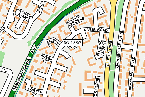
NG11 8RW lies on Prize Close in Nottingham. NG11 8RW is located in the Clifton West electoral ward, within the unitary authority of Nottingham and the English Parliamentary constituency of Nottingham South. The Sub Integrated Care Board (ICB) Location is NHS Nottingham and Nottinghamshire ICB - 52R and the police force is Nottinghamshire. This postcode has been in use since January 1980.


GetTheData
Source: OS OpenMap – Local (Ordnance Survey)
Source: OS VectorMap District (Ordnance Survey)
Licence: Open Government Licence (requires attribution)
| Easting | 454381 |
| Northing | 334152 |
| Latitude | 52.902064 |
| Longitude | -1.192968 |
GetTheData
Source: Open Postcode Geo
Licence: Open Government Licence
| Street | Prize Close |
| Town/City | Nottingham |
| Country | England |
| Postcode District | NG11 |
➜ See where NG11 is on a map ➜ Where is Clifton? | |
GetTheData
Source: Land Registry Price Paid Data
Licence: Open Government Licence
Elevation or altitude of NG11 8RW as distance above sea level:
| Metres | Feet | |
|---|---|---|
| Elevation | 50m | 164ft |
Elevation is measured from the approximate centre of the postcode, to the nearest point on an OS contour line from OS Terrain 50, which has contour spacing of ten vertical metres.
➜ How high above sea level am I? Find the elevation of your current position using your device's GPS.
GetTheData
Source: Open Postcode Elevation
Licence: Open Government Licence
| Ward | Clifton West |
| Constituency | Nottingham South |
GetTheData
Source: ONS Postcode Database
Licence: Open Government Licence
| Krebs Close (Nobel Road) | Clifton | 89m |
| Fleming Gardens (Nobel Road) | Clifton | 98m |
| Fleming Gardens (Nobel Road) | Clifton | 98m |
| Krebs Close (Nobel Road) | Clifton | 110m |
| The Dip (Clifton Lane) | Clifton | 150m |
| Clifton South Tram Stop (N/A) | Clifton | 603m |
| Summerwood Lane Tram Stop (Farnborough Road) | Clifton | 662m |
| Holy Trinity Tram Stop (Southchurch Drive) | Clifton | 968m |
| Clifton Centre Tram Stop (Southchurch Drive) | Clifton | 1,093m |
| Rivergreen Tram Stop (Southchurch Drive) | Clifton | 1,336m |
| Beeston Station | 2.3km |
| Attenborough Station | 2.6km |
| East Midlands Parkway Station | 6.5km |
GetTheData
Source: NaPTAN
Licence: Open Government Licence
| Percentage of properties with Next Generation Access | 100.0% |
| Percentage of properties with Superfast Broadband | 100.0% |
| Percentage of properties with Ultrafast Broadband | 100.0% |
| Percentage of properties with Full Fibre Broadband | 0.0% |
Superfast Broadband is between 30Mbps and 300Mbps
Ultrafast Broadband is > 300Mbps
| Median download speed | 53.8Mbps |
| Average download speed | 76.6Mbps |
| Maximum download speed | 200.00Mbps |
| Median upload speed | 10.0Mbps |
| Average upload speed | 10.9Mbps |
| Maximum upload speed | 17.64Mbps |
| Percentage of properties unable to receive 2Mbps | 0.0% |
| Percentage of properties unable to receive 5Mbps | 0.0% |
| Percentage of properties unable to receive 10Mbps | 0.0% |
| Percentage of properties unable to receive 30Mbps | 0.0% |
GetTheData
Source: Ofcom
Licence: Ofcom Terms of Use (requires attribution)
Estimated total energy consumption in NG11 8RW by fuel type, 2015.
| Consumption (kWh) | 163,234 |
|---|---|
| Meter count | 14 |
| Mean (kWh/meter) | 11,660 |
| Median (kWh/meter) | 11,796 |
| Consumption (kWh) | 49,065 |
|---|---|
| Meter count | 9 |
| Mean (kWh/meter) | 5,452 |
| Median (kWh/meter) | 3,833 |
GetTheData
Source: Postcode level gas estimates: 2015 (experimental)
Source: Postcode level electricity estimates: 2015 (experimental)
Licence: Open Government Licence
GetTheData
Source: ONS Postcode Database
Licence: Open Government Licence


➜ Get more ratings from the Food Standards Agency
GetTheData
Source: Food Standards Agency
Licence: FSA terms & conditions
| Last Collection | |||
|---|---|---|---|
| Location | Mon-Fri | Sat | Distance |
| Nobel Road | 17:00 | 11:00 | 274m |
| Hartness Road | 17:15 | 11:00 | 351m |
| The Pastures Post Office | 17:00 | 11:30 | 617m |
GetTheData
Source: Dracos
Licence: Creative Commons Attribution-ShareAlike
The below table lists the International Territorial Level (ITL) codes (formerly Nomenclature of Territorial Units for Statistics (NUTS) codes) and Local Administrative Units (LAU) codes for NG11 8RW:
| ITL 1 Code | Name |
|---|---|
| TLF | East Midlands (England) |
| ITL 2 Code | Name |
| TLF1 | Derbyshire and Nottinghamshire |
| ITL 3 Code | Name |
| TLF14 | Nottingham |
| LAU 1 Code | Name |
| E06000018 | Nottingham |
GetTheData
Source: ONS Postcode Directory
Licence: Open Government Licence
The below table lists the Census Output Area (OA), Lower Layer Super Output Area (LSOA), and Middle Layer Super Output Area (MSOA) for NG11 8RW:
| Code | Name | |
|---|---|---|
| OA | E00070172 | |
| LSOA | E01013909 | Nottingham 036C |
| MSOA | E02002903 | Nottingham 036 |
GetTheData
Source: ONS Postcode Directory
Licence: Open Government Licence
| NG11 8RU | Robinson Gardens | 49m |
| NG11 8RX | Chamberlain Close | 53m |
| NG11 8RB | Medawar Close | 82m |
| NG11 8RP | Raleigh Close | 92m |
| NG11 8RT | Fleming Gardens | 93m |
| NG11 8RQ | Wilkins Gardens | 96m |
| NG11 8RD | Appleton Close | 121m |
| NG11 8QY | Kendrew Court | 135m |
| NG11 8QZ | Krebs Close | 151m |
| NG11 8RA | Angell Green | 159m |
GetTheData
Source: Open Postcode Geo; Land Registry Price Paid Data
Licence: Open Government Licence