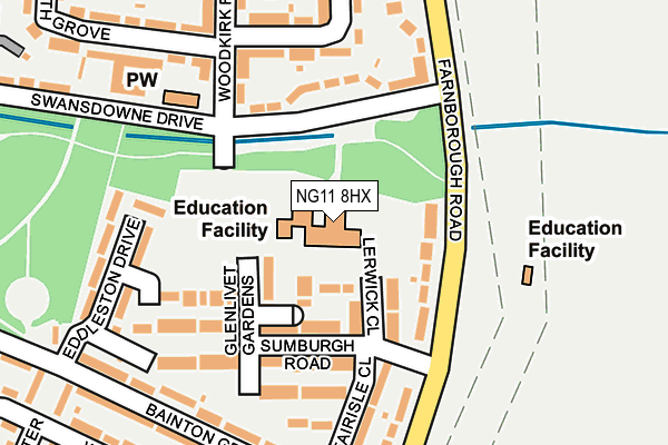
NG11 8HX is located in the Clifton East electoral ward, within the unitary authority of Nottingham and the English Parliamentary constituency of Nottingham South. The Sub Integrated Care Board (ICB) Location is NHS Nottingham and Nottinghamshire ICB - 52R and the police force is Nottinghamshire. This postcode has been in use since January 1980.


GetTheData
Source: OS OpenMap – Local (Ordnance Survey)
Source: OS VectorMap District (Ordnance Survey)
Licence: Open Government Licence (requires attribution)
| Easting | 456040 |
| Northing | 334407 |
| Latitude | 52.904186 |
| Longitude | -1.168263 |
GetTheData
Source: Open Postcode Geo
Licence: Open Government Licence
| Country | England |
| Postcode District | NG11 |
➜ See where NG11 is on a map ➜ Where is Clifton? | |
GetTheData
Source: Land Registry Price Paid Data
Licence: Open Government Licence
Elevation or altitude of NG11 8HX as distance above sea level:
| Metres | Feet | |
|---|---|---|
| Elevation | 30m | 98ft |
Elevation is measured from the approximate centre of the postcode, to the nearest point on an OS contour line from OS Terrain 50, which has contour spacing of ten vertical metres.
➜ How high above sea level am I? Find the elevation of your current position using your device's GPS.
GetTheData
Source: Open Postcode Elevation
Licence: Open Government Licence
| Ward | Clifton East |
| Constituency | Nottingham South |
GetTheData
Source: ONS Postcode Database
Licence: Open Government Licence
| Nethergate School (Swansdowne Drive) | Clifton | 89m |
| Nethergate School (Swansdowne Drive) | Clifton | 127m |
| Central College Nottingham (Farnborough Road) | Clifton | 134m |
| Woodkirk Road (Swansdowne Drive) | Clifton | 156m |
| Central College Nottingham (Farnborough Road) | Clifton | 186m |
| Rivergreen Tram Stop (Southchurch Drive) | Clifton | 530m |
| Clifton Centre Tram Stop (Southchurch Drive) | Clifton | 587m |
| Southchurch Drive North Tram Stop (Southchurch Drive) | Clifton | 742m |
| Holy Trinity Tram Stop (Southchurch Drive) | Clifton | 1,184m |
| Ruddington Lane Tram Stop (Ruddington Lane) | Compton Acres | 1,345m |
| Beeston Station | 3.2km |
| Attenborough Station | 4.3km |
| Nottingham Station | 5km |
GetTheData
Source: NaPTAN
Licence: Open Government Licence
GetTheData
Source: ONS Postcode Database
Licence: Open Government Licence


➜ Get more ratings from the Food Standards Agency
GetTheData
Source: Food Standards Agency
Licence: FSA terms & conditions
| Last Collection | |||
|---|---|---|---|
| Location | Mon-Fri | Sat | Distance |
| Sunburgh Road | 17:30 | 12:00 | 165m |
| Farnborough Road | 17:30 | 11:00 | 298m |
| Dungannon Road | 17:00 | 09:30 | 466m |
GetTheData
Source: Dracos
Licence: Creative Commons Attribution-ShareAlike
The below table lists the International Territorial Level (ITL) codes (formerly Nomenclature of Territorial Units for Statistics (NUTS) codes) and Local Administrative Units (LAU) codes for NG11 8HX:
| ITL 1 Code | Name |
|---|---|
| TLF | East Midlands (England) |
| ITL 2 Code | Name |
| TLF1 | Derbyshire and Nottinghamshire |
| ITL 3 Code | Name |
| TLF14 | Nottingham |
| LAU 1 Code | Name |
| E06000018 | Nottingham |
GetTheData
Source: ONS Postcode Directory
Licence: Open Government Licence
The below table lists the Census Output Area (OA), Lower Layer Super Output Area (LSOA), and Middle Layer Super Output Area (MSOA) for NG11 8HX:
| Code | Name | |
|---|---|---|
| OA | E00070139 | |
| LSOA | E01013900 | Nottingham 035D |
| MSOA | E02002902 | Nottingham 035 |
GetTheData
Source: ONS Postcode Directory
Licence: Open Government Licence
| NG11 8QF | Huntly Close | 81m |
| NG11 8QG | Lerwick Close | 90m |
| NG11 8JT | Swansdowne Drive | 126m |
| NG11 8QE | Sumburgh Road | 127m |
| NG11 8LJ | Farnborough Road | 129m |
| NG11 8QB | Glenlivet Gardens | 152m |
| NG11 8QD | Fairisle Close | 153m |
| NG11 8JS | Foxearth Avenue | 197m |
| NG11 8LF | Bainton Grove | 209m |
| NG11 8QA | Eddlestone Drive | 214m |
GetTheData
Source: Open Postcode Geo; Land Registry Price Paid Data
Licence: Open Government Licence