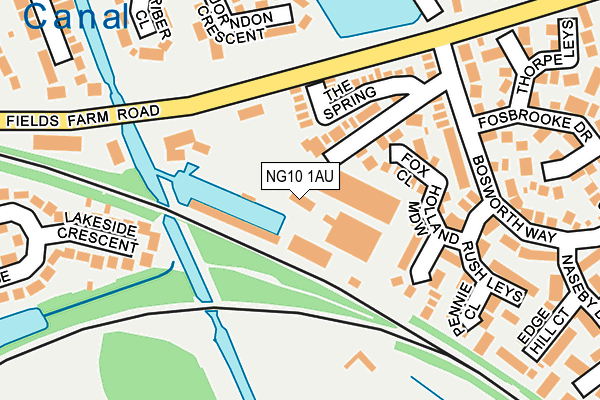
NG10 1AU is located in the Long Eaton Central electoral ward, within the local authority district of Erewash and the English Parliamentary constituency of Erewash. The Sub Integrated Care Board (ICB) Location is NHS Derby and Derbyshire ICB - 15M and the police force is Derbyshire. This postcode has been in use since January 1980.


GetTheData
Source: OS OpenMap – Local (Ordnance Survey)
Source: OS VectorMap District (Ordnance Survey)
Licence: Open Government Licence (requires attribution)
| Easting | 448731 |
| Northing | 332098 |
| Latitude | 52.884142 |
| Longitude | -1.277265 |
GetTheData
Source: Open Postcode Geo
Licence: Open Government Licence
| Country | England |
| Postcode District | NG10 |
➜ See where NG10 is on a map ➜ Where is Long Eaton? | |
GetTheData
Source: Land Registry Price Paid Data
Licence: Open Government Licence
Elevation or altitude of NG10 1AU as distance above sea level:
| Metres | Feet | |
|---|---|---|
| Elevation | 30m | 98ft |
Elevation is measured from the approximate centre of the postcode, to the nearest point on an OS contour line from OS Terrain 50, which has contour spacing of ten vertical metres.
➜ How high above sea level am I? Find the elevation of your current position using your device's GPS.
GetTheData
Source: Open Postcode Elevation
Licence: Open Government Licence
| Ward | Long Eaton Central |
| Constituency | Erewash |
GetTheData
Source: ONS Postcode Database
Licence: Open Government Licence
| Bosworth Way (Fields Farm Road) | Long Eaton | 126m |
| Bosworth Way (Fields Farm Road) | Long Eaton | 138m |
| Fosbrooke Drive (Bosworth Way) | Long Eaton | 173m |
| Fosbrooke Drive (Bosworth Way) | Long Eaton | 184m |
| Naseby Drive (Bosworth Way) | Long Eaton | 221m |
| Long Eaton Station | 0.7km |
| East Midlands Parkway Station | 2.6km |
| Attenborough Station | 3.9km |
GetTheData
Source: NaPTAN
Licence: Open Government Licence
GetTheData
Source: ONS Postcode Database
Licence: Open Government Licence


➜ Get more ratings from the Food Standards Agency
GetTheData
Source: Food Standards Agency
Licence: FSA terms & conditions
| Last Collection | |||
|---|---|---|---|
| Location | Mon-Fri | Sat | Distance |
| Bosworth Way | 17:00 | 12:00 | 289m |
| Wyvern Avenue | 17:30 | 12:00 | 328m |
| Roosevelt Avenue | 16:45 | 12:00 | 502m |
GetTheData
Source: Dracos
Licence: Creative Commons Attribution-ShareAlike
| Risk of NG10 1AU flooding from rivers and sea | Very Low |
| ➜ NG10 1AU flood map | |
GetTheData
Source: Open Flood Risk by Postcode
Licence: Open Government Licence
The below table lists the International Territorial Level (ITL) codes (formerly Nomenclature of Territorial Units for Statistics (NUTS) codes) and Local Administrative Units (LAU) codes for NG10 1AU:
| ITL 1 Code | Name |
|---|---|
| TLF | East Midlands (England) |
| ITL 2 Code | Name |
| TLF1 | Derbyshire and Nottinghamshire |
| ITL 3 Code | Name |
| TLF13 | South and West Derbyshire |
| LAU 1 Code | Name |
| E07000036 | Erewash |
GetTheData
Source: ONS Postcode Directory
Licence: Open Government Licence
The below table lists the Census Output Area (OA), Lower Layer Super Output Area (LSOA), and Middle Layer Super Output Area (MSOA) for NG10 1AU:
| Code | Name | |
|---|---|---|
| OA | E00099551 | |
| LSOA | E01019677 | Erewash 014B |
| MSOA | E02004091 | Erewash 014 |
GetTheData
Source: ONS Postcode Directory
Licence: Open Government Licence
| NG10 1GZ | Fox Close | 100m |
| NG10 1PJ | The Spring | 106m |
| NG10 1HX | Tenter Close | 139m |
| NG10 1HL | Holland Meadow | 149m |
| NG10 3GH | Lakeside Crescent | 189m |
| NG10 1AL | Quorndon Crescent | 201m |
| NG10 1HW | Rush Leys | 203m |
| NG10 1EA | Bosworth Way | 208m |
| NG10 1HN | Pennie Close | 222m |
| NG10 1AN | Riber Close | 243m |
GetTheData
Source: Open Postcode Geo; Land Registry Price Paid Data
Licence: Open Government Licence