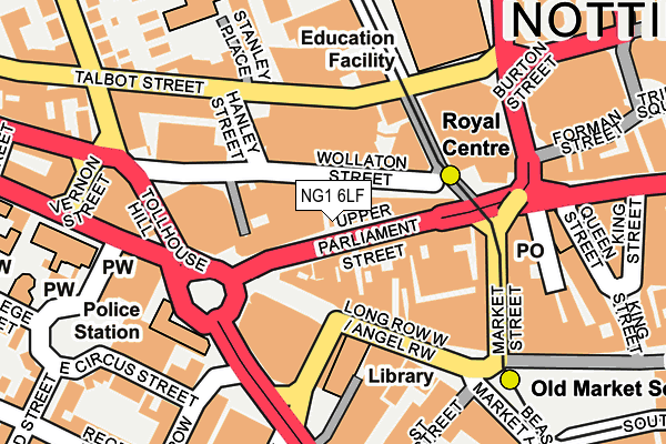
NG1 6LF is located in the Hyson Green & Arboretum electoral ward, within the unitary authority of Nottingham and the English Parliamentary constituency of Nottingham East. The Sub Integrated Care Board (ICB) Location is NHS Nottingham and Nottinghamshire ICB - 52R and the police force is Nottinghamshire. This postcode has been in use since January 1980.


GetTheData
Source: OS OpenMap – Local (Ordnance Survey)
Source: OS VectorMap District (Ordnance Survey)
Licence: Open Government Licence (requires attribution)
| Easting | 456950 |
| Northing | 340050 |
| Latitude | 52.954832 |
| Longitude | -1.153744 |
GetTheData
Source: Open Postcode Geo
Licence: Open Government Licence
| Country | England |
| Postcode District | NG1 |
➜ See where NG1 is on a map ➜ Where is Nottingham? | |
GetTheData
Source: Land Registry Price Paid Data
Licence: Open Government Licence
Elevation or altitude of NG1 6LF as distance above sea level:
| Metres | Feet | |
|---|---|---|
| Elevation | 50m | 164ft |
Elevation is measured from the approximate centre of the postcode, to the nearest point on an OS contour line from OS Terrain 50, which has contour spacing of ten vertical metres.
➜ How high above sea level am I? Find the elevation of your current position using your device's GPS.
GetTheData
Source: Open Postcode Elevation
Licence: Open Government Licence
| Ward | Hyson Green & Arboretum |
| Constituency | Nottingham East |
GetTheData
Source: ONS Postcode Database
Licence: Open Government Licence
| Upper Parliament Street | Nottingham | 34m |
| Upper Parliament Street | Nottingham | 42m |
| Upper Parliament Street | Nottingham | 55m |
| Upper Parliament Street | Nottingham | 63m |
| Angel Row A4 (Angel Row) | Nottingham | 105m |
| Royal Centre Tram Stop (Wollaton Street) | Nottingham | 119m |
| Old Market Square Tram Stop (South Parade) | Nottingham | 283m |
| Ntu Tram Stop (Goldsmith Street) | Nottingham Trent University In City Centre | 403m |
| Lace Market Tram Stop (Fletcher Gate) | Nottingham | 593m |
| High School Tram Stop (Waverley Street) | Arboretum | 1,024m |
| Nottingham Station | 1km |
| Netherfield Station | 5km |
| Beeston Station | 5.2km |
GetTheData
Source: NaPTAN
Licence: Open Government Licence
| Median download speed | 9.0Mbps |
| Average download speed | 8.7Mbps |
| Maximum download speed | 11.25Mbps |
| Median upload speed | 1.0Mbps |
| Average upload speed | 0.9Mbps |
| Maximum upload speed | 1.18Mbps |
GetTheData
Source: Ofcom
Licence: Ofcom Terms of Use (requires attribution)
GetTheData
Source: ONS Postcode Database
Licence: Open Government Licence


➜ Get more ratings from the Food Standards Agency
GetTheData
Source: Food Standards Agency
Licence: FSA terms & conditions
| Last Collection | |||
|---|---|---|---|
| Location | Mon-Fri | Sat | Distance |
| Chapel Bar | 18:45 | 12:30 | 101m |
| Park Row | 18:30 | 144m | |
| Beastmarket Hill | 18:30 | 12:30 | 191m |
GetTheData
Source: Dracos
Licence: Creative Commons Attribution-ShareAlike
The below table lists the International Territorial Level (ITL) codes (formerly Nomenclature of Territorial Units for Statistics (NUTS) codes) and Local Administrative Units (LAU) codes for NG1 6LF:
| ITL 1 Code | Name |
|---|---|
| TLF | East Midlands (England) |
| ITL 2 Code | Name |
| TLF1 | Derbyshire and Nottinghamshire |
| ITL 3 Code | Name |
| TLF14 | Nottingham |
| LAU 1 Code | Name |
| E06000018 | Nottingham |
GetTheData
Source: ONS Postcode Directory
Licence: Open Government Licence
The below table lists the Census Output Area (OA), Lower Layer Super Output Area (LSOA), and Middle Layer Super Output Area (MSOA) for NG1 6LF:
| Code | Name | |
|---|---|---|
| OA | E00173530 | |
| LSOA | E01013816 | Nottingham 022D |
| MSOA | E02002889 | Nottingham 022 |
GetTheData
Source: ONS Postcode Directory
Licence: Open Government Licence
| NG1 6JQ | Chapel Bar | 62m |
| NG1 6LD | Upper Parliament Street | 77m |
| NG1 6JS | Chapel Bar | 91m |
| NG1 6JE | Long Row | 102m |
| NG1 5JS | Goldsmith Street | 127m |
| NG1 5FW | Wollaton Street | 134m |
| NG1 6HQ | Mount Street | 144m |
| NG1 5GD | Hanley Street | 151m |
| NG1 5JT | Goldsmith Street | 152m |
| NG1 6HX | Market Street | 153m |
GetTheData
Source: Open Postcode Geo; Land Registry Price Paid Data
Licence: Open Government Licence
| Wollaton Street | At Any Time | 61m |
| Wollaton Street | At Any Time | 92m |
| Long Row West | At Any Time | 119m |
GetTheData
Source: Disabled parking spaces, Nottingham City Council, 19/02/2013
Licence: Open Government Licence