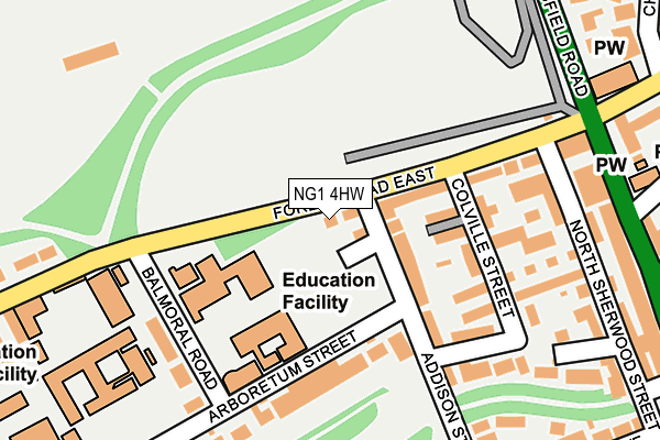
NG1 4HW lies on Forest Road East in Nottingham. NG1 4HW is located in the Hyson Green & Arboretum electoral ward, within the unitary authority of Nottingham and the English Parliamentary constituency of Nottingham East. The Sub Integrated Care Board (ICB) Location is NHS Nottingham and Nottinghamshire ICB - 52R and the police force is Nottinghamshire. This postcode has been in use since March 1982.


GetTheData
Source: OS OpenMap – Local (Ordnance Survey)
Source: OS VectorMap District (Ordnance Survey)
Licence: Open Government Licence (requires attribution)
| Easting | 456774 |
| Northing | 341064 |
| Latitude | 52.963944 |
| Longitude | -1.156189 |
GetTheData
Source: Open Postcode Geo
Licence: Open Government Licence
| Street | Forest Road East |
| Town/City | Nottingham |
| Country | England |
| Postcode District | NG1 |
➜ See where NG1 is on a map ➜ Where is Nottingham? | |
GetTheData
Source: Land Registry Price Paid Data
Licence: Open Government Licence
Elevation or altitude of NG1 4HW as distance above sea level:
| Metres | Feet | |
|---|---|---|
| Elevation | 70m | 230ft |
Elevation is measured from the approximate centre of the postcode, to the nearest point on an OS contour line from OS Terrain 50, which has contour spacing of ten vertical metres.
➜ How high above sea level am I? Find the elevation of your current position using your device's GPS.
GetTheData
Source: Open Postcode Elevation
Licence: Open Government Licence
| Ward | Hyson Green & Arboretum |
| Constituency | Nottingham East |
GetTheData
Source: ONS Postcode Database
Licence: Open Government Licence
53, FOREST ROAD EAST, NOTTINGHAM, NG1 4HW 2007 20 JUL £310,000 |
GetTheData
Source: HM Land Registry Price Paid Data
Licence: Contains HM Land Registry data © Crown copyright and database right 2025. This data is licensed under the Open Government Licence v3.0.
| Forest Road (Mansfield Road) | Arboretum | 256m |
| Forest Road (Mansfield Road) | Arboretum | 270m |
| Huntingdon Street (Mansfield Road) | Nottingham | 327m |
| Forest Gates (Mansfield Road) | Forest Fields | 330m |
| Huntingdon Street (Mansfield Road) | Nottingham | 335m |
| High School Tram Stop (Waverley Street) | Arboretum | 409m |
| Ntu Tram Stop (Goldsmith Street) | Nottingham Trent University In City Centre | 635m |
| The Forest Tram Stop (Noel Street) | The Forest | 754m |
| Noel Street Tram Stop (Noel Street) | Hyson Green | 908m |
| Royal Centre Tram Stop (Wollaton Street) | Nottingham | 1,008m |
| Nottingham Station | 2km |
| Bulwell Station | 4.8km |
| Beeston Station | 5.9km |
GetTheData
Source: NaPTAN
Licence: Open Government Licence
GetTheData
Source: ONS Postcode Database
Licence: Open Government Licence


➜ Get more ratings from the Food Standards Agency
GetTheData
Source: Food Standards Agency
Licence: FSA terms & conditions
| Last Collection | |||
|---|---|---|---|
| Location | Mon-Fri | Sat | Distance |
| Arboretum Street | 18:30 | 12:30 | 163m |
| Mapperley Road/Chestnut Grove | 17:30 | 12:00 | 320m |
| Forest Road East | 17:00 | 12:30 | 327m |
GetTheData
Source: Dracos
Licence: Creative Commons Attribution-ShareAlike
The below table lists the International Territorial Level (ITL) codes (formerly Nomenclature of Territorial Units for Statistics (NUTS) codes) and Local Administrative Units (LAU) codes for NG1 4HW:
| ITL 1 Code | Name |
|---|---|
| TLF | East Midlands (England) |
| ITL 2 Code | Name |
| TLF1 | Derbyshire and Nottinghamshire |
| ITL 3 Code | Name |
| TLF14 | Nottingham |
| LAU 1 Code | Name |
| E06000018 | Nottingham |
GetTheData
Source: ONS Postcode Directory
Licence: Open Government Licence
The below table lists the Census Output Area (OA), Lower Layer Super Output Area (LSOA), and Middle Layer Super Output Area (MSOA) for NG1 4HW:
| Code | Name | |
|---|---|---|
| OA | E00069659 | |
| LSOA | E01013815 | Nottingham 022C |
| MSOA | E02002889 | Nottingham 022 |
GetTheData
Source: ONS Postcode Directory
Licence: Open Government Licence
| NG1 4HB | Addison Street | 33m |
| NG1 4HT | Forest Road East | 55m |
| NG1 4HS | Forest Grove | 109m |
| NG1 4HA | Addison Street | 146m |
| NG1 4HR | Tudor Grove | 158m |
| NG1 4HQ | Colville Street | 169m |
| NG1 4HX | Balmoral Road | 188m |
| NG1 4HJ | Forest Road East | 194m |
| NG1 4EW | North Sherwood Street | 199m |
| NG1 4HN | Colville Villas | 200m |
GetTheData
Source: Open Postcode Geo; Land Registry Price Paid Data
Licence: Open Government Licence